Maps of Malay Archipelago
Indiae Orientalis nec non insularum adiacentium nova descriptio / Per Nicolaum Visscher
1 : 15000000 Annotatie: Privilege: Cum privilegio Ordinum Hollandiae et Westfrisiae; Origineel is Blad 188 in atlas factice; Eerste staat. Later is deze kaart uitgegeven door Petrus Schenk Junior; Annotatie geografische gegevens: 2 schaalstokken, o.a. 150 Milliaria Germanica (=7,4 cm) [Amsterdam : Nicolaus Visscher]
Indiae Orientalis, nec non Insularum Adiacentium Nova Descriptio [Karte], in: Novus atlas absolutissimus, Bd. 9, S. 101.
1 Karte aus Atlas Janssonius Offizin
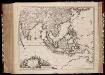
Indiæ orientalis, nec non insularum adiacentium nova descriptio / per Nicolaum Visscher
1 : 15000000 1 Karte : Kupferdruck ; 45 x 55 cm [Nicolaes Visscher]


INDIA | quæ | ORIENTALIS | dicitur | ET | INSVLÆ | ADIACENTES.
[Amsterdam : Joan Blaeu]

Indiae orientalis, nec non insularum adiacentium nova descriptio
1 : 15000000 Asie jihovýchodní Visscher, Nicolaes Jansz.
Indiae orientalis, nec non insularum adiacentium nova descriptio
1 : 15000000 Asie jihovýchodní Visscher, Nicolaus per Nicolaum Visscher
India quae Orientalis dicitur, et Insulae Adiacentes. [Karte], in: Novus atlas absolutissimus, Bd. 6, S. 144.
1 Karte aus Atlas Janssonius Offizin
India quae Orientalis dicitur, Et Insulae Adiacentes. [Karte], in: Theatrum orbis terrarum, sive, Atlas novus, Bd. 2, S. 248.
1 Karte aus Atlas Blaeu, Joan Blaeu, Willem Janszoon
India quae Orientalis dicitur, et Insulae Adiacentes. [Karte], in: Novus Atlas, das ist, Weltbeschreibung, Bd. 2, S. 263.
1 Karte aus Atlas Blaeu, Joan Blaeu, Willem Janszoon
India quae Orientalis dicitur, Et Insulae Adiacentes. [Karte], in: Le théâtre du monde, ou, Nouvel atlas contenant les chartes et descriptions de tous les païs de la terre, Bd. 2, S. 239.
1 Karte aus Atlas Blaeu, Willem Janszoon und Blaeu, Joan Blaeu, Willem Janszoon
Ostindien mit den Inseln
Schul-Atlas über alle Theile der Erde nach dem neuesten Zustande, und über das Weltgebäude Stieler, Adolf Justus Perthes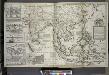
A map of the East-Indies and the adjacent countries ; with the settlements, factories and territories explaning what belongs to England, Spain, France, Holland, Denmark, Portugal &c. ...
from The world described, or, A new and correct sett of maps : shewing the kingdoms and states in all the known parts of the earth, with the principal cities, and most considerable towns in the world ... / ... by Herman Moll, geographer ...
Orientaliora Indiarum Orientalium cum insulis adjacentibus à promontorio C. Comorin ad Iapan
1 Karte : Kupferdruck ; 43 x 54 cm Renard Louis Renard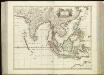
[75][75] Tabula Indiae Orientalis, uit: Atlas sive Descriptio terrarum orbis
Annotatie: Gedigitaliseerde versie. Amsterdam. Heiloo : Picturae (vervaardiger), 2015. tiff-bestand. Gedigitaliseerd: 07-01-2015; Origineel: Universiteitsbibliotheek Vrije Universiteit (XL.05127.-) ; Netherlands; Titelpagina ontbreekt Wit, Frederik de Amsterdam : Frederick de Wit
[139][142] Orientaliora Indiarum orientalium ... Pascaert ... van Oost Indien, uit: Atlas sive Descriptio terrarum orbis
Annotatie: Gedigitaliseerde versie. Amsterdam. Heiloo : Picturae (vervaardiger), 2015. tiff-bestand. Gedigitaliseerd: 07-01-2015; Origineel: Universiteitsbibliotheek Vrije Universiteit (XL.05127.-) ; Netherlands; Titelpagina ontbreekt Wit, Frederik de Amsterdam : Frederick de Wit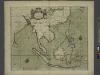
A chart of the eastermost part of the EAST INDIES and CHINA, from cape comarine to IAPAN, with all adjacent Islands
from The sea-atlas : containing an hydrographical description of most of the sea-coasts of the known parts of the world.
Oosterdeel van Oost Indien [Karte], in: De Nieuwe Groote Vermeerderde Zee-Atlas ofte Water-Werelt, S. 59.
1 Karte aus Atlas Doncker, Hendrick
Ost-Indien
Hand-Atlas über alle Theile der Erde und über das Weltgebäude Stieler, Adolf Justus Perthes

Ost-Indien mit den Inseln
Hand-Atlas über alle Theile der Erde nach dem neuesten Zustande und über das Weltgebäude Stieler, Adolf bei Justus Perthes
Ost-Indien.
1 : 18500000 Stulpnagel, F.v.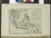
The islands of the East Indies with the channels between India, China & New Holland.
from Carey's general atlas, improved and enlarged : being a collection of maps of the world and quarters, their principal empires, kingdoms, &c.
Ost-Indien
Handatlas über alle Theile der Erde und über das Weltgebäude Stieler, Adolf Justus Perthes
Ost-Indien mit den Inseln
Hand-Atlas über alle Theile der Erde nach dem neuesten Zustande und über das Weltgebäude Stieler, Adolf bei Justus Perthes
Ostindien
Allgemeiner Atlas [Walch, Johannes] im Verlag bei Johannes Walch
Siam, Malacca and the Indian Islands.
from A new systeme of the mathematicks: containing I. Arithmetick, as well natural and decimal, as in species, or the principles of algebra. II. Practical geometry, together with the first six books of Euclid's Elements, as also the eleventh and twelfth, symbo


