Maps of Malay Archipelago


Indiae Orientalis, nec non Insularum Adiacentium Nova Descriptio [Karte], in: Novus atlas absolutissimus, Bd. 9, S. 101.
1 Karte aus Atlas Janssonius Offizin
India quae Orientalis dicitur, Et Insulae Adiacentes. [Karte], in: Le théâtre du monde, ou, Nouvel atlas contenant les chartes et descriptions de tous les païs de la terre, Bd. 2, S. 239.
1 Karte aus Atlas Blaeu, Willem Janszoon und Blaeu, Joan Blaeu, Willem Janszoon
Ostindien mit den Inseln
Schul-Atlas über alle Theile der Erde nach dem neuesten Zustande, und über das Weltgebäude Stieler, Adolf Justus Perthes

India quae Orientalis dicitur, et Insulae Adiacentes. [Karte], in: Novus Atlas, das ist, Weltbeschreibung, Bd. 2, S. 263.
1 Karte aus Atlas Blaeu, Joan Blaeu, Willem Janszoon
India quae Orientalis dicitur, Et Insulae Adiacentes. [Karte], in: Theatrum orbis terrarum, sive, Atlas novus, Bd. 2, S. 248.
1 Karte aus Atlas Blaeu, Joan Blaeu, Willem Janszoon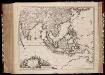
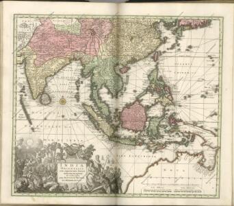
Indiae Orientalis nec non insularum adiacentium nova descriptio / Per Nicolaum Visscher
1 : 15000000 Annotatie: Privilege: Cum privilegio Ordinum Hollandiae et Westfrisiae; Origineel is Blad 188 in atlas factice; Eerste staat. Later is deze kaart uitgegeven door Petrus Schenk Junior; Annotatie geografische gegevens: 2 schaalstokken, o.a. 150 Milliaria Germanica (=7,4 cm) [Amsterdam : Nicolaus Visscher]
INDIA | quæ | ORIENTALIS | dicitur | ET | INSVLÆ | ADIACENTES.
[Amsterdam : Joan Blaeu]
Indiæ orientalis, nec non insularum adiacentium nova descriptio / per Nicolaum Visscher
1 : 15000000 1 Karte : Kupferdruck ; 45 x 55 cm [Nicolaes Visscher]
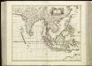
Indiae orientalis, nec non insularum adiacentium nova descriptio
1 : 15000000 Asie jihovýchodní Visscher, Nicolaes Jansz.
Indiae orientalis, nec non insularum adiacentium nova descriptio
1 : 15000000 Asie jihovýchodní Visscher, Nicolaus per Nicolaum Visscher
[139][142] Orientaliora Indiarum orientalium ... Pascaert ... van Oost Indien, uit: Atlas sive Descriptio terrarum orbis
Annotatie: Gedigitaliseerde versie. Amsterdam. Heiloo : Picturae (vervaardiger), 2015. tiff-bestand. Gedigitaliseerd: 07-01-2015; Origineel: Universiteitsbibliotheek Vrije Universiteit (XL.05127.-) ; Netherlands; Titelpagina ontbreekt Wit, Frederik de Amsterdam : Frederick de Wit
India quae Orientalis dicitur, et Insulae Adiacentes. [Karte], in: Novus atlas absolutissimus, Bd. 6, S. 144.
1 Karte aus Atlas Janssonius Offizin

Orientaliora Indiarum Orientalium cum insulis adjacentibus à promontorio C. Comorin ad Iapan
1 Karte : Kupferdruck ; 43 x 54 cm Renard Louis Renard
Oosterdeel van Oost Indien [Karte], in: De Nieuwe Groote Vermeerderde Zee-Atlas ofte Water-Werelt, S. 59.
1 Karte aus Atlas Doncker, Hendrick
Nieuwe kaart van Azië
1 : 12000000 Annotatie: Met afstandentabel (hemelsbreed) [S.l. : Zijlstra]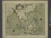
A chart of the eastermost part of the EAST INDIES and CHINA, from cape comarine to IAPAN, with all adjacent Islands
from The sea-atlas : containing an hydrographical description of most of the sea-coasts of the known parts of the world.
2. Atlas des ganzen Erdkreises.
1 : 61000000 Reichard, C. G.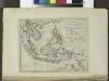
The islands of the East Indies with the channels between India, China & New Holland.
from Carey's general atlas, improved and enlarged : being a collection of maps of the world and quarters, their principal empires, kingdoms, &c.
Far East, Mediterranean Area.
1 : 13000000 Sun Oil Company
[Indischer Ozean, östlicher Teil]
1 Karte : Kupferdruck ; 57 x 45 cm Doncker Hendrik Doncker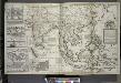
A map of the East-Indies and the adjacent countries ; with the settlements, factories and territories explaning what belongs to England, Spain, France, Holland, Denmark, Portugal &c. ...
from The world described, or, A new and correct sett of maps : shewing the kingdoms and states in all the known parts of the earth, with the principal cities, and most considerable towns in the world ... / ... by Herman Moll, geographer ...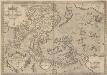
Indiae Orientalis, Insularumque Adiacientium Typus. [Karte], in: Theatrum orbis terrarum, S. 399.
1 Karte aus Atlas Ortelius, Abraham Vrients, Jan Baptista
Ostindien und China
1 : 25000000 Himálaj Kocen, Blaž Eduard Hölzel
Ost-Indien.
1 : 18500000 Stulpnagel, F.v.
Ost-Indien mit den Inseln
Hand-Atlas über alle Theile der Erde nach dem neuesten Zustande und über das Weltgebäude Stieler, Adolf bei Justus Perthes
Ost-Indien
Hand-Atlas über alle Theile der Erde und über das Weltgebäude Stieler, Adolf Justus Perthes