Maps of Korkyně

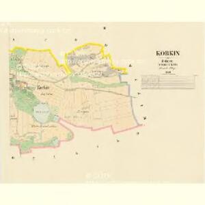
Korkin - c3336-1-001 - Kaiserpflichtexemplar der Landkarten des stabilen Katasters
1 : 2880
Korkin - c3336-1-002 - Kaiserpflichtexemplar der Landkarten des stabilen Katasters
1 : 2880
Krzischow (Křissow) - c3670-1-002 - Kaiserpflichtexemplar der Landkarten des stabilen Katasters
1 : 2880
Krzischow (Křissow) - c3670-1-001 - Kaiserpflichtexemplar der Landkarten des stabilen Katasters
1 : 2880
Zaborna Lhotta - c9008-1-002 - Kaiserpflichtexemplar der Landkarten des stabilen Katasters
1 : 2880
Zaborna Lhotta - c9008-1-003 - Kaiserpflichtexemplar der Landkarten des stabilen Katasters
1 : 2880
Zaborna Lhotta - c9008-1-001 - Kaiserpflichtexemplar der Landkarten des stabilen Katasters
1 : 2880
Chotilsko - c2597-1-001 - Kaiserpflichtexemplar der Landkarten des stabilen Katasters
1 : 2880
Chotilsko - c2597-1-002 - Kaiserpflichtexemplar der Landkarten des stabilen Katasters
1 : 2880
Sudowitz (Sudowice) - c7533-1-002 - Kaiserpflichtexemplar der Landkarten des stabilen Katasters
1 : 2880
Sudowitz (Sudowice) - c7533-1-001 - Kaiserpflichtexemplar der Landkarten des stabilen Katasters
1 : 2880

Karte des Dobřischer Bezirkes im Prager Kreise
1 : 7000 Dobříš-oblast (Česko) Wagner, Jan Eduard Karl André
Karte des Dobřischer Bezirkes im Prager Kreise
1 : 7000 Dobříš-oblast (Česko) Wagner, Jan Eduard Karl André
Přehledná mapa vltavské trati Kamýk-Štěchovice
1 : 25000 Kamýk (Česko : vodní nádrž) Ředitelství pro stavbu vodních cest
Soubor map okresů Pražského kraje

Wotický vikariát
Votice-oblast (Česko)
Benešov
1 : 75000 Benešov (Česko : oblast) Vojenský zeměpisný ústav
Příbramer Vicariat
Příbram-oblast (Česko)
Vilímkovy místopisné mapy zemí Koruny české
1 : 100000 Benešov (Česko : oblast) Srp, Jan Jos. R. Vilímek
Podrobná mapa Království českého
1 : 100000 Benešov (Česko : oblast) Srp, Jan Jaroslav Bursík
Okresní hejtmanství Vinohradské : [samosprávné okresy: Král. Vinohrady-Nusle-Vršovice-Jílové]
1 : 100000
Politický okres Příbram
1 : 100000 Příbram-oblast (Česko) Josef Richard Vilímek
Politický okres Příbram
1 : 100000 Příbram-oblast (Česko) Kratochvíl, M. Josef Richard Vilímek
Okresní hejtmanství Sedlčanské

Situační mapka rudního terrainu v Sedlčanské vysočině
Benešov-oblast (Česko)
Politický okres Příbram 5
Vilímek, Josef Richard
Konigsaal und Beneschau.
from Spezialkarte der osterreichisch-ungarischen Monarchie.
Beraun und Horowitz (Bohmen).
from Spezialkarte der osterreichisch-ungarischen Monarchie.