Maps of Iraq
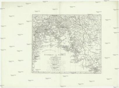
Euphrat und Tigris
1 : 2500000 Eufrat-oblast Anville, Jean-Baptiste Bourguinon d' Schraembl, Franz Anton F.A. Schraembl

Euphrates Valley, Syria, Kurdistan &c.
1 : 3220177 Stanford, Edward
Syria and the Provinces to the Persian Gulf.
1 : 3380000 Sharpe, J.
149-150. East Mediterranean Lands and Iraq. Baghdad. The World Atlas.
1 : 2500000 USSR (Union of Soviet Socialist Republics).
Assyria vetvs divisa in Syriam, Mesopotamiam Babyloniam, & Assyriam proprie dictam
Asýrie La Rue, Philippe de Mortier, Pieter apud Pet. Mortier
Karte des Euphrat von Dscherablus bis Felludscha Karte des Euphrat von Dscherablus bis Felludscha
1 : 400000 Eufrat (řeka) Kartogr. Abteilung der Königl. Preuß. Landesaufnahme
[XXV], uit: Geognostische Karte des Oesterreichischen Kaiserstaates mit einem grossen Theile Deutschland's u. Italien / hauptsachlich nach ... Haidinger's geognostischer Karte dieses Staates bearb. von Josef Scheda
1 : 3000000 titelvariant: General-Karte von Europa in 25 Blättern; Annotatie: Bijlage bij: General-Karte von Europa in 25 Blättern. - 1:2.592.000. - 1845-1847 Scheda, Joseph Wien : K.K. Militär. Geografisch. Institut
Carte de la Syrie
Nouvel atlas physique politique et historique de l'Empire ottoman et des états limitrophes en Europe, en Asie et en Afrique, en quarante feuilles Hellert, J.J. Bellizard, Dufour et Cie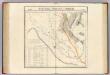
Partie, la Perse, la Turquie. Asie 64.
1 : 1641836 Vandermaelen, Philippe, 1795-1869
Syria.
1 : 3801600 Tallis, J. & F.
Syriae.
1 : 2400000 Vivien de St Martin, L.
Feuille 41 (F VI), uit: Carte géologique internationale de l'Europe : la carte, votée au congrès géologique international de Bologne en 1881, est exécutée conformément aux décisions d'une commission internationale, avec le concours des gouvernements, sous le dir. de M.M. Beyrich et Hauchecorne
Annotatie: Blad 48 gamme des couleurs; blad 49: bladwijzer en titelblad Heinrich Ernst Beyrich 1815-1896; Wi. Hauchecorne Berlin : Reimer / (Berlin: Institut lithographique)
Arménie et Kurdistan
Nouvel atlas physique politique et historique de l'Empire ottoman et des états limitrophes en Europe, en Asie et en Afrique, en quarante feuilles Hellert, J.J. Bellizard, Dufour et Cie
Syria
1 : 2200000 Hughes, William, 1817-1876 George Cox
Ancient Syria to Sinai.
1 : 2200000 Society for the Diffusion of Useful Knowledge (Great Britain)
Syria.
1 : 6500000 Fenner, Rest.
[Levante, Kurdistan]
1 : 1500000 Osmanisches Reich, Levante
Die sogenannten Missionen der Central-TürkeiDas Gebiet der Nestorianer

Die Reiche der Kreuzfahrer um 1142
Kreuzfahrerstaaten
Die Reiche der Kreuzfahrer um 1142
Levante, Kreuzfahrerstaaten
Feuille No. 10, uit: Carte de la Turquie d'Asie (moins l'Arabie) / dessiné et héliogravé au Service géographique de l'Armée
1 : 1000000 titelvariant: Turquie d'Asie; Annotatie: Titel boven de kaart: Turquie d'Asie; Bl. genummerd 1-4 en 7-10; Met lijst van de meest gebruikte woorden op de kaart vertaald uit het Turks, Arabisch en Perzisch; Annotatie geografische gegevens: Inzetkrt. op bl. 9: Plan de Jérusalem et de ses environs, Plan d'Alep, Plan de Damas et de ses faubourgs, Plan de Beyrout et de ses environs (alle 1:50.000) Service géographique de l'Armée [S.l. : Service géographique de l'Armée]
Die Euphrat-Tigris-Länder oder Armenien, Kurdistan und Mesopotamien
1 : 500000 Arménie Kiepert, Heinrich D. Reimer
Etappenstraße Râs el-·Ain - Môsul - Samárra
1 : 400000 Samarra (Irák) Kartogr. Abteilung der Königl. Preuß. Landesaufnahme
Feuille No. 9, uit: Carte de la Turquie d'Asie (moins l'Arabie) / dessiné et héliogravé au Service géographique de l'Armée
1 : 1000000 titelvariant: Turquie d'Asie; Annotatie: Titel boven de kaart: Turquie d'Asie; Bl. genummerd 1-4 en 7-10; Met lijst van de meest gebruikte woorden op de kaart vertaald uit het Turks, Arabisch en Perzisch; Annotatie geografische gegevens: Inzetkrt. op bl. 9: Plan de Jérusalem et de ses environs, Plan d'Alep, Plan de Damas et de ses faubourgs, Plan de Beyrout et de ses environs (alle 1:50.000) Service géographique de l'Armée [S.l. : Service géographique de l'Armée]
Karte von Mesopotamien
1 : 400000 Bagdád (Irák) Kgl. Preuss. Landesaufnahme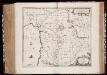
Syriæ, sive Soriæ : nova et accurata descriptio
1 : 1300000 Annotatie: Kaart vervaardigd in ca. 1658; Kaart uitg. tussen ca. 1658-ca. 1680; Origineel is Blad 182 in atlas factice; Annotatie geografische gegevens: Schaalstokken op kaart: 15 Milliaria Germanica Communia (=8,3 cm), en: 20 Milliaria Gallica Communia (=8,3 cm) Johannes Janssonius 1588-1664 Amstelodami : sumptibus Ioannis Ianssonii
Syriae. Sive Soriae. Nova et Accurata descriptio. [Karte], in: Novus atlas absolutissimus, Bd. 6, S. 105.
1 Karte aus Atlas Janssonius Offizin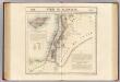
Syrie et Palestine. Asie 63.
1 : 1641836 Vandermaelen, Philippe, 1795-1869