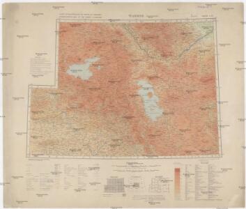
Maps of West Azerbaijan Province

Carte internationale du monde au 1,000,000 E
1 : 1000000 Tabríz (Írán) War Office
Iraq-Iran 1:100,000, K601, Kelek
Iraq-Iran 1:100,000, K601. United States. Army Map Service. Washington, D.C. : Army Map Service
Iraq-Iran 1:100,000, K601, Mosul
Iraq-Iran 1:100,000, K601. United States. Army Map Service. Washington, D.C. : Army Map Service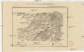
Plan sraženija pri Bulanlykě
1 : 18000
Einnahme von Erzerum 25ten Juni 1829
1 : 120000 Erzurum Eroberung, Russisch-Türkischer Krieg <1828-1829>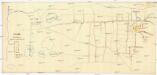
Wan
1 : 3600 Van (Turecko)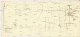
Wan
1 : 3600 Van (Turecko)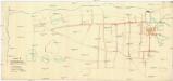
Wan
1 : 3600 Van (Turecko)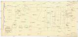
Wan
1 : 3600 Van (Turecko)
Karte vom Môsul und Umgebung
1 : 20000 Kartographische Abteilung des Stellvertr. Generalstab der Armee
[Erzurum]
Türkei Erzurum Militäroperation Russland. Armīja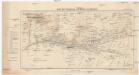
Karte der Umgebung von Mardin und Ne\0219ibîn
1 : 200000 Kartogr. Abteilung der Königl. Preuß. Landesaufnahme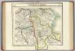
Partie, la Perse. Asie 52.
1 : 1641836 Vandermaelen, Philippe, 1795-1869
Arménie et Kurdistan
Nouvel atlas physique politique et historique de l'Empire ottoman et des états limitrophes en Europe, en Asie et en Afrique, en quarante feuilles Hellert, J.J. Bellizard, Dufour et Cie
No.29. Karta Evropeyskaia Rossiia. Sheet 15
1 : 2000000 Shokalskago,Iu. M.
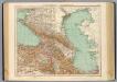
[Westküste des Kaspischen Meeres]
Kaspické moře (oblast)
Feuille No. 4, uit: Carte de la Turquie d'Asie (moins l'Arabie) / dessiné et héliogravé au Service géographique de l'Armée
1 : 1000000 titelvariant: Turquie d'Asie; Annotatie: Titel boven de kaart: Turquie d'Asie; Bl. genummerd 1-4 en 7-10; Met lijst van de meest gebruikte woorden op de kaart vertaald uit het Turks, Arabisch en Perzisch; Annotatie geografische gegevens: Inzetkrt. op bl. 9: Plan de Jérusalem et de ses environs, Plan d'Alep, Plan de Damas et de ses faubourgs, Plan de Beyrout et de ses environs (alle 1:50.000) Service géographique de l'Armée [S.l. : Service géographique de l'Armée]
Asiat. Turkey 2.
1 : 2050000 Grassl, J. (Joseph)
[Karte des östlichen Kleinasien]
Malá Asie
[Kars]
Türkei Kars (Region) Militäroperation Russland. Armīja
Etappenstraße Râs el-·Ain - Môsul - Samárra
1 : 400000 Samarra (Irák) Kartogr. Abteilung der Königl. Preuß. Landesaufnahme
[Tertia Asie tabula] [Karte], in: Clavdii Ptholomei Viri Alexandrini Cosmographie, S. 170.
1 Karte aus Atlas Nicolaus Germanus [und Ptolemaeus, Claudius]
Friedensdislokation im europäischen Russland
1 : 3125000 Kavkaz-oblast
Charte générale du pays entre les mers Noire et Caspienne
1 : 2300000 Kaspické moře-oblast Darmet, J. M. T. Mollo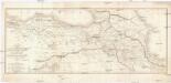
CARTE DES PAYS COMPRIS ENTRE CONSTANTINOPLE ET TÉHÉRAN
1 : 2230000 Arménie Lapie, Pierre Flahaut
Byzantinische Reich, ostliches Blatt.
1 : 3800000 Spruner von Merz, Karl
[XX], uit: Geognostische Karte des Oesterreichischen Kaiserstaates mit einem grossen Theile Deutschland's u. Italien / hauptsachlich nach ... Haidinger's geognostischer Karte dieses Staates bearb. von Josef Scheda
1 : 3000000 titelvariant: General-Karte von Europa in 25 Blättern; Annotatie: Bijlage bij: General-Karte von Europa in 25 Blättern. - 1:2.592.000. - 1845-1847 Scheda, Joseph Wien : K.K. Militär. Geografisch. Institut
Carte General de la Turquie d'Asie.
1 : 4200000 Vivien de St Martin, L.
Kaerte van de waerschijnlijkste plaets van den Hof van Eden, de vlakte van Sinear, en den berg, waer op d'Ark gerust heeft, volgens deeze histori
Annotatie: Afkomstig uit dl. I van: Algemeene histori van het begin der wereld af tot den tegenwoordigen tijd toe / ... door Kornelis Westerbaen Wz. - Utrecht : Hermanus Besseling, 1735-1755; Rechtsboven: I Deel tusschen bl. 460 en 461 [Utrecht : H. Besseling excudit]