Maps of Eastern Anatolia Region

[Karte des östlichen Kleinasien]
Malá Asie
Feuille No. 4, uit: Carte de la Turquie d'Asie (moins l'Arabie) / dessiné et héliogravé au Service géographique de l'Armée
1 : 1000000 titelvariant: Turquie d'Asie; Annotatie: Titel boven de kaart: Turquie d'Asie; Bl. genummerd 1-4 en 7-10; Met lijst van de meest gebruikte woorden op de kaart vertaald uit het Turks, Arabisch en Perzisch; Annotatie geografische gegevens: Inzetkrt. op bl. 9: Plan de Jérusalem et de ses environs, Plan d'Alep, Plan de Damas et de ses faubourgs, Plan de Beyrout et de ses environs (alle 1:50.000) Service géographique de l'Armée [S.l. : Service géographique de l'Armée]
Carte de la frontiere Russo Turque dans l'Asie mineure
1 : 840000 Arménie Köke, F. Artaria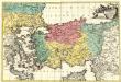
Seconde Feuille du Theatre de la Guerre entre les Russes et les Turcs
1 : 2200000 Mollova mapová sbírka Probst, Johann Michael Probst, Johann Michael
[Kars]
Türkei Kars (Region) Militäroperation Russland. Armīja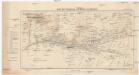
Karte der Umgebung von Mardin und Ne\0219ibîn
1 : 200000 Kartogr. Abteilung der Königl. Preuß. Landesaufnahme
[Kars]
Türkei Kars (Region) Militäroperation Russland. Armīja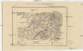
Plan sraženija pri Bulanlykě
1 : 18000
[Erzurum]
Türkei Erzurum Militäroperation Russland. Armīja
[Ardahan]
Türkei Ardahan Militäroperation Russland. Armīja
Einnahme von Erzerum 25ten Juni 1829
1 : 120000 Erzurum Eroberung, Russisch-Türkischer Krieg <1828-1829>
[Zevin]
Türkei Militäroperation Russland. Armīja
Kars
1 : 50000
Belagerung von Kars 19ten bis 23ten Juni 1828
1 : 120000 Kars Belagerung, Russisch-Türkischer Krieg <1828-1829>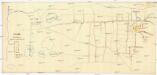
Wan
1 : 3600 Van (Turecko)
Wan
1 : 3600 Van (Turecko)
Wan
1 : 3600 Van (Turecko)
Wan
1 : 3600 Van (Turecko)
Karte vom Môsul und Umgebung
1 : 20000 Kartographische Abteilung des Stellvertr. Generalstab der Armee
[Kars]
Türkei Kars (Region) Militäroperation Russland. Armīja
[Kars]
Türkei Kars (Region) Militäroperation Russland. Armīja
[Kars]
Türkei Kars (Region) Militäroperation Russland. Armīja
Karte der asiatischen Türkei
1 : 200000 Turecko Kartogr. Abteilung der Kgl. Preuß. Landesaufnahme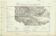
Plan du siége et de l'assaut d' Akhaltsikh du 5 au 15 aout par les troupes Rousses sous les ordres du Maréchal Paskewitch
Avril, Ch. V. Martenon
Iraq-Iran 1:100,000, K601, Mosul
Iraq-Iran 1:100,000, K601. United States. Army Map Service. Washington, D.C. : Army Map Service
Asiat. Turkey 2.
1 : 2050000 Grassl, J. (Joseph)
[Specialkarte der Asiatischen Türkey, II. Blatt, Armenien und Theile von Klein-Asien, Syrien & Mesopotamien]
Grosser Hand-Atlas über alle Theile der Erde in 170 Karten Meyer, J. Verlag des Bibliographischen Instituts
Arménie et Kurdistan
Nouvel atlas physique politique et historique de l'Empire ottoman et des états limitrophes en Europe, en Asie et en Afrique, en quarante feuilles Hellert, J.J. Bellizard, Dufour et Cie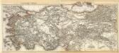
Composite: Asiat. Turkey.
1 : 2050000 Grassl, J. (Joseph)
![[Karte des östlichen Kleinasien]](https://images-2.georeferencer.com/images/iiif/480637959403/full/,300/0/native.jpg)

