Maps of Iraqi Kurdistan

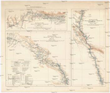
Etappenstraße Râs el-·Ain - Môsul - Samárra
1 : 400000 Samarra (Irák) Kartogr. Abteilung der Königl. Preuß. Landesaufnahme
Kirkuk
1 : 253440 First World War map of Kirkuk. Sheet T.C. 147 War Office
Iraq-Iran 1:100,000, K601, Kelek
Iraq-Iran 1:100,000, K601. United States. Army Map Service. Washington, D.C. : Army Map Service
Iraq-Iran 1:100,000, K601, Mosul
Iraq-Iran 1:100,000, K601. United States. Army Map Service. Washington, D.C. : Army Map Service
Tikrit
1 : 63360 First World War map of Tikrit. Sheet T.C. 105c. War Office
Karte vom Môsul und Umgebung
1 : 20000 Kartographische Abteilung des Stellvertr. Generalstab der Armee
Die Euphrat-Tigris-Länder oder Armenien, Kurdistan und Mesopotamien
1 : 500000 Arménie Kiepert, Heinrich D. Reimer
Feuille No. 10, uit: Carte de la Turquie d'Asie (moins l'Arabie) / dessiné et héliogravé au Service géographique de l'Armée
1 : 1000000 titelvariant: Turquie d'Asie; Annotatie: Titel boven de kaart: Turquie d'Asie; Bl. genummerd 1-4 en 7-10; Met lijst van de meest gebruikte woorden op de kaart vertaald uit het Turks, Arabisch en Perzisch; Annotatie geografische gegevens: Inzetkrt. op bl. 9: Plan de Jérusalem et de ses environs, Plan d'Alep, Plan de Damas et de ses faubourgs, Plan de Beyrout et de ses environs (alle 1:50.000) Service géographique de l'Armée [S.l. : Service géographique de l'Armée]
Karte von Mesopotamien
1 : 400000 Bagdád (Irák) Kgl. Preuss. Landesaufnahme
Prof. C. Haussknecht's Routen im Orient 1865-1869 : III. Kurdistan und Irak
1 : 800000 Kiepert, Heinrich, 1818-1899 Verlag von Dietrich Reimer
Karte des Euphrat von Dscherablus bis Felludscha Karte des Euphrat von Dscherablus bis Felludscha
1 : 400000 Eufrat (řeka) Kartogr. Abteilung der Königl. Preuß. Landesaufnahme
Arménie et Kurdistan
Nouvel atlas physique politique et historique de l'Empire ottoman et des états limitrophes en Europe, en Asie et en Afrique, en quarante feuilles Hellert, J.J. Bellizard, Dufour et Cie
Euphrat und Tigris
1 : 2500000 Eufrat-oblast Anville, Jean-Baptiste Bourguinon d' Schraembl, Franz Anton F.A. Schraembl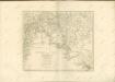

Assyria vetvs divisa in Syriam, Mesopotamiam Babyloniam, & Assyriam proprie dictam
Asýrie La Rue, Philippe de Mortier, Pieter apud Pet. Mortier
Syria and the Provinces to the Persian Gulf.
1 : 3380000 Sharpe, J.
Charta tēs Hellados en hē periechontai hai nēsoi autēs [kai] meros tōn eis tēn Eurōpēn [kai] Mikran Asian polyarithmōn apoikiōn autēs
1 : 600000 R?gas, Velestinl?s, 1757?-1798 Franz Müller
Euphrates Valley, Syria, Kurdistan &c.
1 : 3220177 Stanford, Edward
149-150. East Mediterranean Lands and Iraq. Baghdad. The World Atlas.
1 : 2500000 USSR (Union of Soviet Socialist Republics).
Byzantinische Reich, ostliches Blatt.
1 : 3800000 Spruner von Merz, Karl
[XX], uit: Geognostische Karte des Oesterreichischen Kaiserstaates mit einem grossen Theile Deutschland's u. Italien / hauptsachlich nach ... Haidinger's geognostischer Karte dieses Staates bearb. von Josef Scheda
1 : 3000000 titelvariant: General-Karte von Europa in 25 Blättern; Annotatie: Bijlage bij: General-Karte von Europa in 25 Blättern. - 1:2.592.000. - 1845-1847 Scheda, Joseph Wien : K.K. Militär. Geografisch. Institut
Carte de la situation du paradis terrestre, et des pais habitez par les patriarches
1 : 5000000 Blízký východ Huet, Pierre-Daniel Mortier, Pieter chez Pierre Mortier
[Tertia Asie tabula] [Karte], in: Clavdii Ptholomei Viri Alexandrini Cosmographie, S. 170.
1 Karte aus Atlas Nicolaus Germanus [und Ptolemaeus, Claudius]
[XXV], uit: Geognostische Karte des Oesterreichischen Kaiserstaates mit einem grossen Theile Deutschland's u. Italien / hauptsachlich nach ... Haidinger's geognostischer Karte dieses Staates bearb. von Josef Scheda
1 : 3000000 titelvariant: General-Karte von Europa in 25 Blättern; Annotatie: Bijlage bij: General-Karte von Europa in 25 Blättern. - 1:2.592.000. - 1845-1847 Scheda, Joseph Wien : K.K. Militär. Geografisch. Institut
Ansiedelungsschwerpunkte von Bulgarien-Türken 1950/51
Türkei Türken, Siedlung
Friedensdislokation im europäischen Russland
1 : 3125000 Kavkaz-oblast
Carte de la Syrie
Nouvel atlas physique politique et historique de l'Empire ottoman et des états limitrophes en Europe, en Asie et en Afrique, en quarante feuilles Hellert, J.J. Bellizard, Dufour et Cie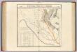
Partie, la Perse, la Turquie. Asie 64.
1 : 1641836 Vandermaelen, Philippe, 1795-1869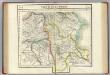
Partie, la Perse. Asie 52.
1 : 1641836 Vandermaelen, Philippe, 1795-1869