Maps of Mesopotamia

Byzantinische Reich, ostliches Blatt.
1 : 3800000 Spruner von Merz, Karl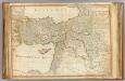
Turkey in Asia.
1 : 2900000 Robert Laurie & James Whittle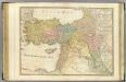
Turkey in Asia.
1 : 2900000 Anville, Jean Baptiste Bourguignon d, 1697-1782
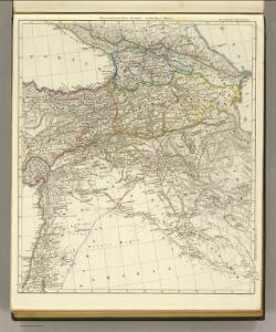
Asiatische Turkey.
1 : 4000000 Ziegler, J. M.
Afbeelding van alle de landen gelegen tusschen de Middellandsche, Zwarte, Caspische, Persische en Rode Zeeën : benevens derzelver rivieren, bergen, berugtste steden enz. : alles met derzelver aloude namen uitgedrukt, zo als verstrekt tot opheldering van de aards-vaderlyke geschiedenis
1 : 4000000 door W.A. Bachiene J. van Jagen sculp. 1747 ; J. Punt inv. et fecit. Uitgegeven te Gorinchem : by Nicolaas Goetzee
Carte General de la Turquie d'Asie.
1 : 4200000 Vivien de St Martin, L.
Aperçu general de la division administrative des provinces asiatiques de l'empire Ottoman
osmanská říše Kiepert, Heinrich D. Reimer
Turkey, Israel, Cyprus, Lebanon, Syria, Iraq, Jordan. Pergamon World Atlas.
Polish Army Topography Service
[XX], uit: Geognostische Karte des Oesterreichischen Kaiserstaates mit einem grossen Theile Deutschland's u. Italien / hauptsachlich nach ... Haidinger's geognostischer Karte dieses Staates bearb. von Josef Scheda
1 : 3000000 titelvariant: General-Karte von Europa in 25 Blättern; Annotatie: Bijlage bij: General-Karte von Europa in 25 Blättern. - 1:2.592.000. - 1845-1847 Scheda, Joseph Wien : K.K. Militär. Geografisch. Institut
L'Euphrate et le Tigre
1 : 2400000 Anville, Jean Baptiste Bourguignon d', 1697-1782 [s.n.]

Kaerte van de waerschijnlijkste plaets van den Hof van Eden, de vlakte van Sinear, en den berg, waer op d'Ark gerust heeft, volgens deeze histori
Annotatie: Afkomstig uit dl. I van: Algemeene histori van het begin der wereld af tot den tegenwoordigen tijd toe / ... door Kornelis Westerbaen Wz. - Utrecht : Hermanus Besseling, 1735-1755; Rechtsboven: I Deel tusschen bl. 460 en 461 [Utrecht : H. Besseling excudit]
Euphrates Valley, Syria, Kurdistan &c.
1 : 3220177 Stanford, Edward
Turkey in Asia.
1 : 4100000 Hall, S. (Sidney)
Charta tēs Hellados en hē periechontai hai nēsoi autēs [kai] meros tōn eis tēn Eurōpēn [kai] Mikran Asian polyarithmōn apoikiōn autēs
1 : 600000 R?gas, Velestinl?s, 1757?-1798 Franz Müller
CARTE DES PAYS COMPRIS ENTRE CONSTANTINOPLE ET TÉHÉRAN
1 : 2230000 Arménie Lapie, Pierre Flahaut
Arménie et Kurdistan
Nouvel atlas physique politique et historique de l'Empire ottoman et des états limitrophes en Europe, en Asie et en Afrique, en quarante feuilles Hellert, J.J. Bellizard, Dufour et Cie
Euphrat und Tigris
1 : 2500000 Eufrat-oblast Anville, Jean-Baptiste Bourguinon d' Schraembl, Franz Anton F.A. Schraembl
[Tertia Asie tabula] [Karte], in: Clavdii Ptholomei Viri Alexandrini Cosmographie, S. 170.
1 Karte aus Atlas Nicolaus Germanus [und Ptolemaeus, Claudius]
Syria and the Provinces to the Persian Gulf.
1 : 3380000 Sharpe, J.
Charte générale du pays entre les mers Noire et Caspienne
1 : 2300000 Kaspické moře-oblast Darmet, J. M. T. Mollo
[Specialkarte der Asiatischen Türkey, II. Blatt, Armenien und Theile von Klein-Asien, Syrien & Mesopotamien]
Grosser Hand-Atlas über alle Theile der Erde in 170 Karten Meyer, J. Verlag des Bibliographischen Instituts
Feuille 41 (F VI), uit: Carte géologique internationale de l'Europe : la carte, votée au congrès géologique international de Bologne en 1881, est exécutée conformément aux décisions d'une commission internationale, avec le concours des gouvernements, sous le dir. de M.M. Beyrich et Hauchecorne
Annotatie: Blad 48 gamme des couleurs; blad 49: bladwijzer en titelblad Heinrich Ernst Beyrich 1815-1896; Wi. Hauchecorne Berlin : Reimer / (Berlin: Institut lithographique)
Friedensdislokation im europäischen Russland
1 : 3125000 Kavkaz-oblast
Partie, la Perse. Asie 52.
1 : 1641836 Vandermaelen, Philippe, 1795-1869
Assyria vetvs divisa in Syriam, Mesopotamiam Babyloniam, & Assyriam proprie dictam
Asýrie La Rue, Philippe de Mortier, Pieter apud Pet. Mortier
149-150. East Mediterranean Lands and Iraq. Baghdad. The World Atlas.
1 : 2500000 USSR (Union of Soviet Socialist Republics).
[Levante, Kurdistan]
1 : 1500000 Osmanisches Reich, Levante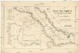
Karte des Euphrat von Dscherablus bis Felludscha Karte des Euphrat von Dscherablus bis Felludscha
1 : 400000 Eufrat (řeka) Kartogr. Abteilung der Königl. Preuß. Landesaufnahme