Maps of Balkan Pen.
Augustissimi et invictissimi romanorum imperatoris haereditarium regnum Hungaria
1 : 2000000 Besarábie (Moldavsko a Ukrajina) Sedlmeyer, Ioannis Pauli Heckenauer, Jakob Wilhelm J. P. Sedlmeyer
Theatrum Belli Russo-Turcici
1 : 2100000 Mollova mapová sbírka Probst, Johann Michael
Novissima Tabula Regni Hungariae et Regionum quondam ei unitarum
1 : 2000000 Mollova mapová sbírka Ottens, Josua Keyser, Jacob Ottens, Josua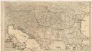
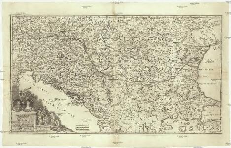
Regni Hungariae, et regionum, quae ei quondam fuere unitae, ut Transilvaniae, Valachiae, Moldaviae, Serviae, Romaniae, Bulgariae, Bessarabiae, Croatiae, Bosniae, Dalmatiae, Sclavoniae, Morlachiae, Ragusanae reipublicae maximaeq[ue] partis Danubii fluminis novissima delineatio
1 : 2100000 Besarábie (Moldavsko a Ukrajina) Wit, Frederick de ex officina Frederici de Wit
90-91. Danube Countries. The World Atlas.
1 : 2500000 USSR (Union of Soviet Socialist Republics).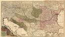
Regni Hungariae et Regionum
1 : 2100000 Mollova mapová sbírka Wit, Frederik de Covens, Johannes I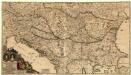
Augustissimi et Invictissimi Romanorum Imperatoris Caroli VI. Haereditarium Regnum Hungaria
1 : 4000000 Mollova mapová sbírka Sedelmayer, Johann Paul Heckenauer, Jakob Wilhelm Sedlmayr, Johann Paul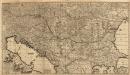
Regni Hungariae et Regionum
1 : 2100000 Mollova mapová sbírka Wit, Frederik de Wit, Frederick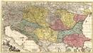
Theatrum Belli Russo-Turcici.
1 : 2100000 Mollova mapová sbírka Probst, Johann Michael Probst, Johann Michael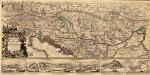
Le Cours du Danvbe depuis sa Source Iusqu'a ses Embouchures
1 : 1900000 Mollova mapová sbírka Sanson, Guillaume Jaillot, Alexis Hubert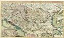
Theatre de la Guerre en Hongrie, Bosnie, Servie, et Tartarie Crimee, en il Grandes Feuilles
1 : 2000000 Mollova mapová sbírka Briffaut, Etienne Briffaut, Etienne
CARTE DU COURS DU DANUBE depuis Ulm jusqu'a son embouchure dans la Mer noire
Dunaj (Rumunsko a Ukrajina : řeka : delta) Artaria & Compagnie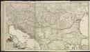
[79][79]Regni Hungariae, ..., uit: Atlas sive Descriptio terrarum orbis
Annotatie: Gedigitaliseerde versie. Amsterdam. Heiloo : Picturae (vervaardiger), 2015. tiff-bestand. Gedigitaliseerd: 07-01-2015; Origineel: Universiteitsbibliotheek Vrije Universiteit (XL.05127.-) ; Netherlands; Titelpagina ontbreekt Wit, Frederik de Amsterdam : Frederick de Wit
Fluminum princeps Danubius
1 : 1900000 Dunaj (řeka : oblast) Valk, Gerhard Gerardo Valk
Exactissima Totius Danubii Fluvii Tabula et minores in eum influentes Fluvii cum Omnibus adjantibus Regionibus
1 : 2000000 Mollova mapová sbírka Danckerts, Theodorus Danckerts, Theodor
Fluminum Princeps Danubius
1 : 1900000 Mollova mapová sbírka Valk, Gerhard Valck, Gerard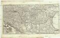
Novissima et accuratissima toti. regni Hungariae, Dalmatiae, Croatiae, Sclavoniae, Bosniae, Serviae, Transylvaniae, cum adiacentib. regnis et provinciis tabula
1 : 1600000 Bosna Sandrart, Johann Jakob von J. J. von Sandrart
Ungarn u. seine Nebenländer vom Anfang des XIII Jahrhunderts bis zur Schlacht bei Mohacs 1526
1 : 3700000 Ungarn
Der Donauraum
1 : 1500000 Dunaj-oblast Justus Perthes
Ungarn in seinen kirchlichen Verhältnissen vom Anfang des XIV Jahrh. bis zur Reformation
1 : 3700000 Ungarn Kirchengeschichte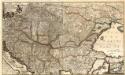
Accurate Landkarte die Königreiche Ober- und Nieder-Hungarn, Slavonien, Croatien, Dalmatien, Bosnien, Servien, Bulgarien, und Romanien, das Groß Fürstenthum Siebenbürgen, die Fürstenthümer Moldau, Wallachey, Bessarabien, die Oczakowisch- und Crimische Tartarey, die Pohlnische Provinz Podolien, wie auch ein Theil von Ukranien, und übrige angränzende Ländere
Mollova mapová sbírka Lidl, Johann Jakob Lidl, Johann Jacob
Österreich-Ungarn
1 : 4500000 Österreich-Ungarn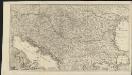
Novissima tabula regni Hungariae et regionum quondam ei unitarum ut Transilvaniae, Valachiae, Moldaviae, Serviae, Romaniae, Bulgariae, Bessarabiae, Croatiae, Bosniae, Dalmatiae, Slavoniae, Morlachiae et reipublicae Ragusanae : accedit pars magna dominii Veneti [...]
1 : 2000000 auctore Reinier & Josua Ottens geographe Amstelodamensi J. Keyser sculpsit Te Amsterdam : by Reinier & Iosua Ottens [...]
Österreich-Ungarn, Staatenkarte
1 : 4500000 Österreich-Ungarn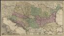
Novissima tabula regni Hungariae et regionum quondam ei unitarum ut Transilvaniae, Valachiae, Moldaviae, Serviae, Romaniae, Bulgariae, Bessarabiae, Croatiae, Bosniae, Dalmatiae, Slavoniae, Morlachiae et reipublicae Ragusanae : accedit pars magna dominii Veneti [...]
1 : 2000000 auctore Reinier & Josua Ottens geographe Amstelodamensi J. Keyser sculpsit Te Amsterdam : by Reinier & Iosua Ottens [...]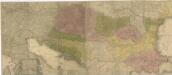
Carte geographique representant le théatre de la guerre entre les Russes, les Turcs, et les Polonis Confédérés ...

Regnum Hungariae, in quo continentur Regiones
1 : 5900000 Mollova mapová sbírka Bruggen, Johann van der Brugge, Johannes van der
Regnum Hungariae, in quo continentur Regiones :
1 : 5900000 Mollova mapová sbírka Bruggen, Johann van der Brugge, Johannes van der
Totius regni Hungariae et adjacentium regionum tabula
1 : 2177000 Dunaj-oblast Visscher, Nicolaes Jansz. per Nicolaum Visscher