Maps of Malaysia
REDUZIRTE KARTE vom CHINESISCHEN MEERE
1 : 2350000 Asie jihovýchodní Berghaus, Heinrich Karl Wilhelm Brose, Wilhelm J. Perthes
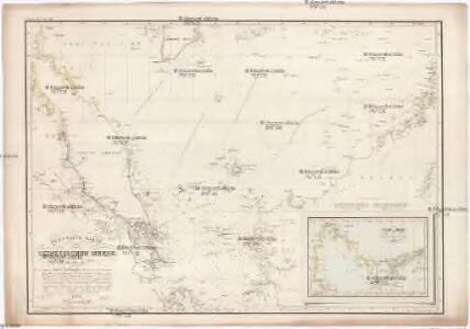
Reduzirte Karte vom Chinesischen Meere, 1.stes oder Südliches Blatt
1 : 2300000 H. Berghaus gestochen von W. Jaeck u. W. Brose Gotha : Perthes
Reduzirte Karte vom Chinesischen Meere.
Jihočínské moře Berghaus, Heinrich Karl Wilhelm Horsburgh, James J. Perthes
Kaart van het eiland Borneo
Grav. en druk van T. Hooiberg te Leiden te 's Hage : uitgave van K. Fuhri
Borneo / Geogr[aphische] lith[ographie] v[an] E. de Geest
Seyffardt's Boekhandel Amsterdam Amsterdam : Seyffardt's Boekhandel
Kaart van het Noordelijk gedeelte benoorden 1ÿê N.B. van het eiland Borneo / [J.W. Stemfoort en J.J. ten Siethoff ; gereproduceerd op last van het Departement van Koloniën, aan de Topographische Inrichting te 's-Gravenhage, onder leiding van den Directeur C.A. Eckstein]
Ministerie van Koloniën Den Haag s-Gravenhage : Departement van Koloniën
Borneo
1 : 5000000 Annotatie: Linksonder: Molengraaff, Borneo; Proefdruk, bestemd voor, maar uiteindelijk niet opgenomen in: Geologische verkenningstochten in Centraal-Borneo (1893-94) / G.A.F. Molengraaff. - Leiden : Brill ; [etc.], 1900 [S.l. : s.n.] / (Leiden : Trap)
Kaart van het eiland Borneo / Topographisch Bureau
Topographisch Bureau Batavia Batavia : Topographisch Bureau
Concept oudheidkundige kaart van Borneo

Overzichtskaart van het eiland Borneo : met aanduiding van de politieke indeeling, de organisatie van het bestuur, de bestaande en nog aan te leggen verkeerswegen en van de groote cultuur- en industrieele centra / samengesteld op last van de N.I. regeering [door de] Topographische Inrichting, Batavia
Topografische Inrichting Batavia Batavia : Topographische Inrichting
Borneo / Top[ographische] Inr[ichting]
Topographische Inrichting Batavia Batavia : Top[ographische] Inr[ichting]
Kalimantan
[S.l. : s.n.]
Blad XXII Boven-Kapoewas, blad o, uit: Residentie Wester-Afdeeling van Borneo : weg- en rivierkaart / Topographisch Bureau
1 : 50000 Annotatie: Voor aanwezige bladen zie overzichtsblad Topographisch Bureau, Batavia Batavia : Topographisch Bureau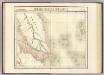
Presqu'ile de Malacca. Oceanique no. 12.
1 : 1641836 Vandermaelen, Philippe, 1795-1869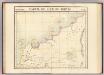
Partie, Borneo. Oceanique no. 13.
1 : 1641836 Vandermaelen, Philippe, 1795-1869
Geologische overzichtskaart van het schiereiland Malakka en omgeving = Geological map of British Malaya / J.B. Scrivenor
Landsdrukkerij Batavia [Weltevreden (Batavia) : Landsdrukkerij]
Blad XXII Boven-Kapoewas, blad g, uit: Residentie Wester-Afdeeling van Borneo : weg- en rivierkaart / Topographisch Bureau
1 : 50000 Annotatie: Voor aanwezige bladen zie overzichtsblad Topographisch Bureau, Batavia Batavia : Topographisch Bureau
British Possessions In The Indian Seas.
Fullarton, A. & Co.
Blad XII Ketoengau, blad p, uit: Residentie Wester-Afdeeling van Borneo : weg- en rivierkaart / Topographisch Bureau
1 : 50000 Annotatie: Voor aanwezige bladen zie overzichtsblad Topographisch Bureau, Batavia Batavia : Topographisch Bureau
Sarawak / U.S. Army Map Service
U.S. Army Map Service Washington D.C. Washington D.C. : U.S. Army Map Service
China Sea / Survey of India
Survey of India [S.l.] : Survey of India
Sarawak / samengesteld en gedrukt bij den Topografischen Dienst
Topografische Dienst Batavia Batavia : Topografische Dienst
Singapore / Survey of India
Survey of India [S.l.] : Survey of India
Blad XXIV Boven Serawai, blad a, uit: Residentie Wester-Afdeeling van Borneo : weg- en rivierkaart / Topographisch Bureau
1 : 50000 Annotatie: Voor aanwezige bladen zie overzichtsblad Topographisch Bureau, Batavia Batavia : Topographisch Bureau
Blad XXIV Boven Serawai, blad b, uit: Residentie Wester-Afdeeling van Borneo : weg- en rivierkaart / Topographisch Bureau
1 : 50000 Annotatie: Voor aanwezige bladen zie overzichtsblad Topographisch Bureau, Batavia Batavia : Topographisch Bureau
Blad XVIII Batang Loepar, blad g, uit: Residentie Wester-Afdeeling van Borneo : weg- en rivierkaart / Topographisch Bureau
1 : 50000 Annotatie: Voor aanwezige bladen zie overzichtsblad Topographisch Bureau, Batavia Batavia : Topographisch Bureau
Blad XIII Sanggau, blad l, uit: Residentie Wester-Afdeeling van Borneo : weg- en rivierkaart / Topographisch Bureau
1 : 50000 Annotatie: Voor aanwezige bladen zie overzichtsblad Topographisch Bureau, Batavia Batavia : Topographisch Bureau
Westkust van Borneo
[S.l. : s.n.]
Kaart van een gedeelte van Borneo : met aanwijzing van de grens tusschen het Nederlandsche gebied en dat van het Britsche protectoraat / Top. Inrichting
Topographische Inrichting Batavia [Batavia] : Top[ographische] Inrichting