Maps of Malaysia
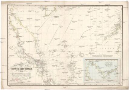
Reduzirte Karte vom Chinesischen Meere.
Jihočínské moře Berghaus, Heinrich Karl Wilhelm Horsburgh, James J. Perthes
REDUZIRTE KARTE vom CHINESISCHEN MEERE
1 : 2350000 Asie jihovýchodní Berghaus, Heinrich Karl Wilhelm Brose, Wilhelm J. Perthes
Reduzirte Karte vom Chinesischen Meere, 1.stes oder Südliches Blatt
1 : 2300000 H. Berghaus gestochen von W. Jaeck u. W. Brose Gotha : Perthes
Kaart van het Noordelijk gedeelte benoorden 1ÿê N.B. van het eiland Borneo / [J.W. Stemfoort en J.J. ten Siethoff ; gereproduceerd op last van het Departement van Koloniën, aan de Topographische Inrichting te 's-Gravenhage, onder leiding van den Directeur C.A. Eckstein]
Ministerie van Koloniën Den Haag s-Gravenhage : Departement van Koloniën
Geologische overzichtskaart van het schiereiland Malakka en omgeving = Geological map of British Malaya / J.B. Scrivenor
Landsdrukkerij Batavia [Weltevreden (Batavia) : Landsdrukkerij]
China Sea / Survey of India
Survey of India [S.l.] : Survey of India
Blad XXIV Boven Serawai, blad b, uit: Residentie Wester-Afdeeling van Borneo : weg- en rivierkaart / Topographisch Bureau
1 : 50000 Annotatie: Voor aanwezige bladen zie overzichtsblad Topographisch Bureau, Batavia Batavia : Topographisch Bureau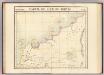
Partie, Borneo. Oceanique no. 13.
1 : 1641836 Vandermaelen, Philippe, 1795-1869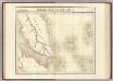
Presqu'ile de Malacca. Oceanique no. 12.
1 : 1641836 Vandermaelen, Philippe, 1795-1869
British Possessions In The Indian Seas.
Fullarton, A. & Co.
[Malaka]
Topografische Dienst Batavia Batavia : Reproductiebedrijf Topografische Dienst
Kaart van een gedeelte van Borneo : met aanwijzing van de grens tusschen het Nederlandsche gebied en dat van het Britsche protectoraat / Top. Inrichting
Topographische Inrichting Batavia [Batavia] : Top[ographische] Inrichting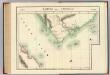
Partie de Camboge. Asie 110.
1 : 1641836 Vandermaelen, Philippe, 1795-1869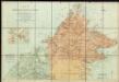
A map of British North Borneo.

Blad XXIV Boven Serawai, blad a, uit: Residentie Wester-Afdeeling van Borneo : weg- en rivierkaart / Topographisch Bureau
1 : 50000 Annotatie: Voor aanwezige bladen zie overzichtsblad Topographisch Bureau, Batavia Batavia : Topographisch Bureau
North Borneo / Topografische Dienst
Topografische Dienst Batavia Batavia : Reproductiebedrijf Topografische Dienst
Blad XXI Boven Embaloeh (2) en Blad XXII Boven Kapoewas, uit: Residentie Wester-Afdeeling van Borneo / Topographisch Bureau
1 : 200000 titelvariant: Residentie Westerafdeeling van Borneo; Annotatie: Titelvariant: Residentie Westerafdeeling van Borneo; Voor aanwezige bladen zie overzichtsblad; Annotatie geografische gegevens: Opname: 1886-1895 Topographisch Bureau, Batavia Batavia : Topographisch Bureau
North Borneo / U.S. Army Map Service
U.S. Army Map Service Washington D.C. Washington D.C. : U.S. Army Map Service
Sarawak / U.S. Army Map Service
U.S. Army Map Service Washington D.C. Washington D.C. : U.S. Army Map Service
Blad VII Siding, blad g, uit: Residentie Wester-Afdeeling van Borneo : weg- en rivierkaart / Topographisch Bureau
1 : 50000 Annotatie: Voor aanwezige bladen zie overzichtsblad Topographisch Bureau, Batavia Batavia : Topographisch Bureau
Singapore / Survey of India
Survey of India [S.l.] : Survey of India
Sarawak / samengesteld en gedrukt bij den Topografischen Dienst
Topografische Dienst Batavia Batavia : Topografische Dienst
Sabah

Brunei / Survey of India
Survey of India [S.l.] : Survey of India
Anambas Eilanden / Survey of India
Survey of India [S.l.] : Survey of India
Pattani [Map of the Province of]
Map of the Province of Pattani. Scale, 1 : 320,000. Bangkok : Royal Survey Department
Miri / compilation: LHQ Cartographic Coy., Aust. Svy. Corps
Australian Survey Corps . LHQ Cartographic Company [S.l.] : LHQ Cartographic Coy
Kudat / compilation: LHQ Cartographic Coy., Aust. Svy. Corps
Australian Survey Corps . LHQ Cartographic Company [S.l.] : LHQ Cartographic Coy
Gouv[ernemen]t Sumatra : Res[identie] Riouw / Topografische Dienst, Batavia
[S.l. : s.n.]