Maps of Pahang

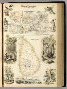
British Possessions In The Indian Seas.
Fullarton, A. & Co.
Geologische overzichtskaart van het schiereiland Malakka en omgeving = Geological map of British Malaya / J.B. Scrivenor
Landsdrukkerij Batavia [Weltevreden (Batavia) : Landsdrukkerij]
[Malaka]
Topografische Dienst Batavia Batavia : Reproductiebedrijf Topografische Dienst
[P[oelau] Roepat]
Topografische Dienst Batavia Batavia : Reproductiebedrijf Topografische Dienst
Kaart van een gedeelte van Sumatra's Oostkust
Aardrijkskundig Genootschap Amsterdam Amsterdam : C.L. Brinkman
Poeak / published by War Office = uitgegeven door War Office ; revised and photolithographed by War Office
War Office Washington D.C. [Washington D.C.] : War Office
Singapore / published under the direction of the Chief of Engineers U.S. Army by the Army Map Service
Army Map Service U.S. Army Washington D.C. Washington D.C. : Army Map Service
Port Dickson / prepared under the direction of the Chief of Engineers U.S. Army ; by the Army Map Service
Army map Service U.S. Army Washington D.C. [Washington D.C.] : Army Map Service
Kotatengah / published by War Office = uitgegeven door War Office ; revised and photolithographed by War Office
War Office Washington D.C. [Washington D.C.] : War Office
Lagoi / published under the direction of the Chief of Engineers U.S. Army by the Army Map Service
Army Map Service U.S. Army Washington D.C. Washington D.C. : Army Map Service
Bagan-siapiapi / published by War Office = uitgegeven door War Office ; revised and photolithographed by War Office
War Office Washington D.C. [Washington D.C.] : War Office
Bengkalis / published by War Office = uitgegeven door War Office ; revised and photolithographed by War Office
War Office Washington D.C. [Washington D.C.] : War Office
[Laboehanbilik] : opgenomen door den Topografischen Dienst in 1925-1926
Topografische Dienst Weltevreden (Batavia) Weltevreden (Batavia) : Reproductiebedrijf Topografische Dienst
Singapore and its dependencies [Map of the isle] (1911)
Map of the island of Singapore and its dependencies, GSGS 2609. Great Britain. General Staff. Geographical Section. [London] : [GSGS, War Office]
[Kotapinang-Baroe] : opgenomen door den Topografischen Dienst in 1924-1926
Topografische Dienst Weltevreden (Batavia) Weltevreden (Batavia) : Reproductiebedrijf Topografische Dienst
[Batoepandjang] / opgenomen door den Topografischen Dienst in 1931-1932
Topografische Dienst Batavia Batavia : Reproductiebedrijf Topografische Dienst
[Poeak] / opgenomen door den Topografischen Dienst in 1932
Topografische Dienst Batavia Batavia : Reproductiebedrijf Topografische Dienst
[Kebonbaroe] / opgenomen door den Topografischen Dienst in 1926-1927
Topografische Dienst Batavia Batavia : Reproductiebedrijf Topografische Dienst
[Langadai] / opgenomen door den Topografischen Dienst in 1926-1928
Topografische Dienst Batavia Batavia : Reproductiebedrijf Topografische Dienst
[Daloedaloe] / opgenomen door den Topografischen Dienst in 1927-1929
Topografische Dienst Batavia Batavia : Reproductiebedrijf Topografische Dienst
[Bagan-Siapiapi] / opgenomen door den Topografischen Dienst in 1926-1931
Topografische Dienst Batavia Batavia : Reproductiebedrijf Topografische Dienst
Ketampoetih / published War Office
War Office Washington [Washington D.C.] : War Office
[Bagansemoet] / opgenomen door den Topografischen Dienst in 1926-1927
Topografische Dienst Batavia Batavia : Reproductiebedrijf Topografische Dienst
[Titinaka] / opgenomen door den Topografischen Dienst in 1931-1932
Topografische Dienst Batavia Batavia : Reproductiebedrijf Topografische Dienst
[Ajabajani] / opgenomen door den Topografischen Dienst in 1930-1931
Topografische Dienst Batavia Batavia : Reproductiebedrijf Topografische Dienst
[Pekaitan] / opgenomen door den Topografischen Dienst in 1926-1927
Topografische Dienst Batavia Weltevreden (Batavia) : Reproductiebedrijf Topografische Dienst
[Sintong] / opgenomen door den Topografischen Dienst in 1926-1928
Topografische Dienst Batavia Batavia : Reproductiebedrijf Topografische Dienst
[Pangkalanpasir] / opgenomen door den Topografischen Dienst in 1926-1928
Topografische Dienst Batavia Batavia : Reproductiebedrijf Topografische Dienst
[Kasangbangsawan] / opgenomen door den Topografischen Dienst in 1926-1927
Topografische Dienst Batavia Batavia : Reproductiebedrijf Topografische Dienst