Maps of Myanmar

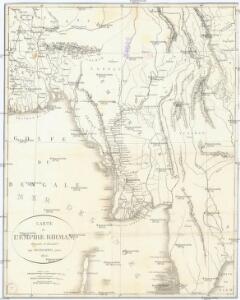
Carte de l'Empire Birman
1 : 5500000 Myanma Desmadryl
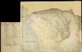
Birmah, with part of Anam and Siam
1 : 3300000 Hall, Sidney Printed for Longman, Rees, Orme, Brown and Green
Birmah, Anam, Siam.
1 : 3300000 Hall, S. (Sidney)
Burmah
1 : 9000000 Annin & Smith Lincoln & Edmands
Burma, OR 5574
One sheet within a four-sheet series, OR 5574, that contains both color and monochrome maps. Great Britain. War Office. [London] : [War Office]
Burma, Andaman & Nicobar Is., Sumatra and Thailand showing the airfields in Japanese occupied territory[a series of maps of] (1944)
[A series of maps of Burma, Andaman & Nicobar Is., Sumatra and Thailand showing the airfields in Japanese occupied territory and allied occupied territory], HIND Misc./6773. Great Britain. War Office. General Staff. Geographical Section. [London] : G.S.G.S. Rep. Sec.
Burma, adjacent countries.
1 : 1520640 Stanford, Edward
Die britische Provinz Pegu und der südliche Theil von Barma
1 : 3000000 Myanma Kiepert, Heinrich Yule, H. D. Reimer
Partie, l'Empire Birman. Asie 104.
1 : 1641836 Vandermaelen, Philippe, 1795-1869
Partie, l'Empire Birman. Asie 96.
1 : 1641836 Vandermaelen, Philippe, 1795-1869
International 1:1,000,000 map
1 : 1000000 Royal Survey Department
Skeleton map to illustrate generally the Agreement of Feb. 4 1897 between Great Britain and China modifying Convention of March 1st 1894
Skeleton map to illustrate generally the Agreement of Feb. 4 1897 between Great Britain and China modifying Convention of March 1st 1894, IDWO 1267. Map shows both boundaries, that of 1897 enlarging Burmese territory. Inset shows Meung Mao area enlarged to 1:506,880. Corrected 1907. Great Britain. War Office. Intelligence Division. [London] : [War Office, Intelligence Division]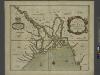
A mapp of the greate river GANGES as ir emptieth it selfe into the bay of BENGALA
from The sea-atlas : containing an hydrographical description of most of the sea-coasts of the known parts of the world.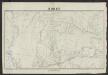
Korat
1 : 500000 Indochine. Service géographique [Hanoï] : Service géographique de l'Indochine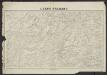
Luang Prabang
1 : 500000 Indochine. Service géographique [Hanoï] : Service géographique de l'Indochine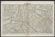
Laokay
1 : 500000 Indochine. Service géographique [Hanoï] : Service géographique de l'Indochine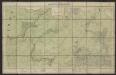
Carte de l'Indochine au 1:500 000. Feuille N4, Luang-Prabang
1 : 500000 Indochine. Service géographique Service géographique de l'Indochine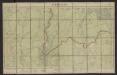
Carte de l'Indochine au 1:500 000. Feuille N7, Vientiane
1 : 500000 Indochine. Service géographique Service géographique de l'Indochine
Ning-erh
1 : 2500000 United States. Army Map Service. Army Map Service
Meng-tzu
1 : 2500000 United States. Army Map Service. Army Map Service
Mien-ning
1 : 2500000 United States. Army Map Service. Army Map Service
Lan-ts'ang
1 : 2500000 United States. Army Map Service. Army Map Service
De revier van Siam
1 : 165000 [S.l.] : [s.n.]
Bengal [Bay of]
[Bay of Bengal. Gulf of Martaban. Moulmein River and approaches. Surveyed ... 1898-99]
Burma, No 84 P/13
This range contains maps and associated documents acquired by, or transferred to, the India Office Records, in the FCO between 1 January 1974 and 31 March 1982 and in The British Library after 1 April 1982. Survey of India
Burma, No 93 D/1
This range contains maps and associated documents acquired by, or transferred to, the India Office Records, in the FCO between 1 January 1974 and 31 March 1982 and in The British Library after 1 April 1982. Survey of India
Burma, No 84 P/14
This range contains maps and associated documents acquired by, or transferred to, the India Office Records, in the FCO between 1 January 1974 and 31 March 1982 and in The British Library after 1 April 1982. Survey of India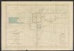
Carte du groupe et du parc d'Angkor : arrêté du 21 mai 1930
1 : 40000 Parmentier, Henri 1871-1949; École française d'Extrême-Orient [Hanoï] : [Ecole française d'Extrême-Orient]
Burma, Meiktilla Sheet 5
Maps described in the 1878 published catalogue Survey of India