Maps of আগ্রাবাদ
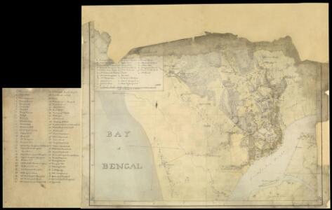
Fragment of map of Chittagong (Bengal), 23 January, 1818, by John Cheape, Bengal Engineers.
Pen-and-ink and water-colour fragment of a map of Chittagong by John Cheape(1792-1875) in 1818. Chittagong, located in Bangladesh at the point where the Karnaphuli River empties into the Bay of Bengal, is a significant port and has been used for centuries by Arakanese, Arab, Persian, Portuguese and Mughal sailors. Under the Portuguese in the 16th century the town was known as Porto Grande and became an important trading centre. It was captured by the Nawab of Bengal in 1666 and fell to the East India Company in 1760; 60 years later it was claimed by the emperor of Burma (now known as Myanmar) and this led to conflict between Burma and the United Kingdom in 1824. After Independence in 1947 Chittagong was part of East Pakistan but became part of the new nation of Bangladesh in 1971. Today Chittagong is the second largest city in Bangladesh, an important commercial centre and the site of a steel mill and oil refinery. Cheape, John (1792-1875), Artist
Bengal, Bahar &c. (south)
1 : 750000 Robert Laurie & James Whittle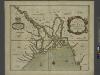
A mapp of the greate river GANGES as ir emptieth it selfe into the bay of BENGALA
from The sea-atlas : containing an hydrographical description of most of the sea-coasts of the known parts of the world.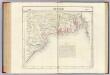
Bengale. Asie 95.
1 : 1641836 Vandermaelen, Philippe, 1795-1869
India 8.
1 : 2217600 Letts, Son & Co.
India VIII. Bengal Presidency.
1 : 2200000 Society for the Diffusion of Useful Knowledge (Great Britain)
Die britische Provinz Pegu und der südliche Theil von Barma
1 : 3000000 Myanma Kiepert, Heinrich Yule, H. D. Reimer
Karte von Asam, Ost-Bengalen und Nord-Birma
1 : 2275000 Bengálsko Mahlmann, Heinrich Etzel, Franz August von D. Reimer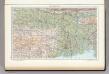
142. Lower Ganga (Ganges) Valley. The World Atlas.
1 : 2500000 USSR (Union of Soviet Socialist Republics).
The Province of Bengal
India Office reference collection of maps Survey of India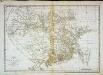
Carte du Bengale et de ses dépendances
1 Karte : Kupferdruck ; 37 x 53 cm Bolts s.n.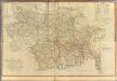
Composite: Bengal, Bahar &c.
1 : 750000 Robert Laurie & James Whittle
Burma, adjacent countries.
1 : 1520640 Stanford, Edward
Provinces of the Lower Ganges.
1 : 2000000 John Bartholomew & Co.
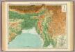
The Province of Bengal and Assam
India Office reference collection of maps Survey of India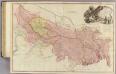
Bengal, Bahar, Oude, Allahabad.
1 : 1480000 Rennell, James, 1742-1830
Burma, Andaman & Nicobar Is., Sumatra and Thailand showing the airfields in Japanese occupied territory[a series of maps of] (1944)
[A series of maps of Burma, Andaman & Nicobar Is., Sumatra and Thailand showing the airfields in Japanese occupied territory and allied occupied territory], HIND Misc./6773. Great Britain. War Office. General Staff. Geographical Section. [London] : G.S.G.S. Rep. Sec.
Gangetic Hindoostan or the countries occupied by the Ganges and the branches
1 : 7000000 Cary, John, ca. 1754-1835 J. Cary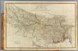
N. Hindostan.
1 : 1480000 Robert Laurie & James Whittle
Burmah
1 : 9000000 Annin & Smith Lincoln & Edmands
Birmah, Anam, Siam.
1 : 3300000 Hall, S. (Sidney)
Birmah, with part of Anam and Siam
1 : 3300000 Hall, Sidney Printed for Longman, Rees, Orme, Brown and Green
Carte de l'Empire Birman
1 : 5500000 Myanma Desmadryl
Burma, OR 5574
One sheet within a four-sheet series, OR 5574, that contains both color and monochrome maps. Great Britain. War Office. [London] : [War Office]

Map of the East Indian Railway
India - north-eastern section.
1 : 4000000 John Bartholomew & Co.
Burma und Malayische Halbinsel
1 : 6000000 Malajsie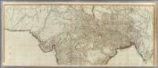
(Hindoostan north)
1 : 2500000 Robert Laurie & James Whittle