Maps of Ayeyarwady
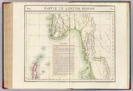
Partie, l'Empire Birman. Asie 104.
1 : 1641836 Vandermaelen, Philippe, 1795-1869
Bengal [Bay of]
[Bay of Bengal. Gulf of Martaban. Moulmein River and approaches. Surveyed ... 1898-99]
Carte de l'Empire Birman
1 : 5500000 Myanma Desmadryl
Burmah
1 : 9000000 Annin & Smith Lincoln & Edmands
Die britische Provinz Pegu und der südliche Theil von Barma
1 : 3000000 Myanma Kiepert, Heinrich Yule, H. D. Reimer
International 1:1,000,000 map
1 : 1000000 Royal Survey Department

Burma und Malayische Halbinsel
1 : 6000000 Malajsie
[Zuidoost-Azië] / [J.F. van Essen]
1 : 6650000 Annotatie: Gerestaureerd, 1995 Essen, J. F. van [Antwerpen : J.F. van Essen]
Birmah, with part of Anam and Siam
1 : 3300000 Hall, Sidney Printed for Longman, Rees, Orme, Brown and Green
Birmah, Anam, Siam.
1 : 3300000 Hall, S. (Sidney)
Birman Empire.
1 : 3700000 Thomson, John
Indochine.
1 : 5000000 Vivien St Martin, L.
地圖綜要 : 三卷(西南海夷圖)
地圖綜要 南明弘光元年(1645),吴学俨等编纂,李釜源鉴定,朗润堂藏板。 该书为明末军事防务地图集,涉及诸多江防、海防、边防等相关地图和解说,军事意味明显,这与成书背景有密切关系。该书在江南刊刻成书之际,清军已大举入关,大明王朝覆灭,仅剩南明小王朝残喘于南方,军事防务至关重要。也因其明显的南明立场,该书被列为四库禁毁书。全书分总卷、内卷和外卷三部分。燕京藏本共八册,书前序言、凡例和目录的总卷部分缺失。 总卷论及大明疆域沿革、军事防守要害、各省道里等内容,地图有《華夷古今形勝圖》,未画方,标绘各府所在,在空白处标注史地简介;《天下各鎮各邊要圖》,未画方,标注北方边防各山口关隘、东南海防、西南边防等;《京省合宿分界圖》,未画方,图上方标注各星宿,对应大明各府州;《天下輿地分里總圖》,计里画方,每方五百里,绘制两京十三省各府所在地。 内卷为两京十三省的建置总数、分里图、分界图、各府州县志、总论及事宜,其中,建制总数包括府州县卫所及各类机构数量、户数、口数、税、钞、丝、绢、盐、马草等数量;分里图采用计里画方,分别绘制两京十三省各府、州、县、卫所及山川河流名;分界图则以突出府界和州县的相对位置,并不追求里程的准确性,因此,与分里图相比,不仅删去了山川地名和解说,而且地图变形较大,以便于较为疏朗地标注各府州县地名;各府州县志则包括省内各府的山川河流、土产古迹、名宦人物等通常为方志所记载的内容;总论高度概括各地历史和地理形势;事宜则多论及该地的军事守备要领。每省分里图和分界图各一幅。 外卷主要为江防、海防、边防相关地图和图说。包括《長江會源分里全圖》《江防全圖》《漕河分里圖》《黃河分里圖》《海防全圖》《日本島夷入寇要害圖》《海運分里圖》《九邊總圖》及九边分图《遼東沿邊圖》《薊鎮沿邊圖》《宣府沿邊圖》《大同沿邊圖》《山西沿邊圖》《大同山西二邊分里合圖》《延綏沿邊圖》《寧夏沿邊圖》《固原沿邊圖》《甘肅沿邊圖》《四夷總圖》及四夷分图《東北諸夷圖》《朝鮮圖》《日本圖》《琉球圖》《東南海夷圖》《東南濱海諸夷圖》《西南海夷圖》《安南圖》《迤北西番諸夷圖》《西域圖》《朔漠圖》等。 在外卷诸图中,以《江防全圖》规模最大、绘制最为详细,并附有详细的解说,显然,这与当时南明小王朝偏居南方的局势密切相关,天堑长江实际上已经成为南明小王朝最后的屏障。 在图例上,府用正方形,州用菱形(包括土州),县用椭圆,卫所用椭圆外加四方短线,但图上大多数卫所并没有标志。 李釜源名茹春,崇祯十年(1637 年)进士,知华亭县。 《中國古籍善本書目》著录。 8册64图,墨刻本,中文,尺寸24.7 x 16.3 cm,计里画方。 Harvard-Yenching | Rare Book | T 3080.7 2925,Harvard-Yenching | Microfilm | FC9113, Master Microforms | Offsite Storage | Film Mas 34483;Hollis Number:008094513 吴学俨等 朗润堂
[Undecima Asie tabula] [Karte], in: Clavdii Ptholomei Viri Alexandrini Cosmographie, S. 188.
1 Karte aus Atlas Nicolaus Germanus [und Ptolemaeus, Claudius]
Indonesia, Thailand and Malaya. Pergamon World Atlas.
1 : 5000000 Polish Army Topography Service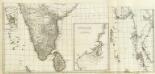
(Carte de l'Inde. Southern section).
1 : 3100000 Anville, Jean Baptiste Bourguignon d, 1697-1782
India, East including Burma (Myanmar), Siam (Thailand), and French Indo-China (Vietnam).
1 : 6997000 Hammond, C.S.
Burmah, Siam, Cochin China.
1 : 4600000 Arrowsmith, John
Undecima Asie Tabula [Karte], in: [Clavdii Ptholomei Cosmographi ...], S. 332.
1 Karte aus Atlas Nicolaus Germanus [und Ptolemaeus, Claudius]
Carte des missions catholiques du Siam, de la Birmanie et du Laos
1 : 3000000 [Lyon : Oeuvre de la propagation de la foi]
Burmah, Siam, and Cochin China.
1 : 4500000 Arrowsmith, John
Entwurf des Birmanschen Reichs
Zadní Indie Dalrymple, Alexander Berra, Marco
ENTWURF des BIRMANSCHEN REICHS
Kambodža Dalrymple, Alexander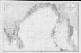
Bay of Bengal
Indian Ocean. Bay of Bengal. Compiled from the latest Government Surveys, 1880. London : Admiralty
131-132. Indochina. The World Atlas.
1 : 5000000 USSR (Union of Soviet Socialist Republics).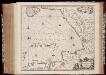
Sinus Gangeticus; vulgo Golfo de Bengala nova descriptio
1 : 4500000 Annotatie: Zeekaart; Kaart uitg. in de periode vanaf ca. 1650 tot ca. 1680; Origineel is Blad 190 in atlas factice; Annotatie geografische gegevens: Schaalstokken op de kaart: 45 Milliaria Germanica communia (=7,5 cm), en: 60 Milliaria Gallica communia (=7,5 cm); Westen boven Johannes Janssonius 1588-1664 [Amstelodami] : [Apud Ioannem Ianssonium]
Sinus Gangeticus: Vulgo Golfo De Bengala Nova descriptio. [Karte], in: Novus atlas absolutissimus, Bd. 9, S. 115.
1 Karte aus Atlas Janssonius Offizin
Sinus Gangeticus; Vulgo Golfo De Bengala Nova descriptio. [Karte], in: Het vijfde Deel Des Grooten Atlas : Vervatende De Water-Weereld, S. 92.
1 Karte aus Atlas Jansson, Jan Jansson, Jan