Maps of Shan State

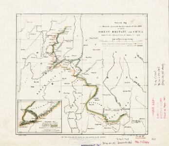
Skeleton map to illustrate generally the Agreement of Feb. 4 1897 between Great Britain and China modifying Convention of March 1st 1894
Skeleton map to illustrate generally the Agreement of Feb. 4 1897 between Great Britain and China modifying Convention of March 1st 1894, IDWO 1267. Map shows both boundaries, that of 1897 enlarging Burmese territory. Inset shows Meung Mao area enlarged to 1:506,880. Corrected 1907. Great Britain. War Office. Intelligence Division. [London] : [War Office, Intelligence Division]
Yün-hsien
1 : 2500000 United States. Army Map Service. Army Map Service
Mien-ning
1 : 2500000 United States. Army Map Service. Army Map Service
Lung-ling
1 : 2500000 United States. Army Map Service. Army Map Service
Lan-ts'ang
1 : 2500000 United States. Army Map Service. Army Map Service
Ta-li
1 : 2500000 United States. Army Map Service. Army Map Service
T'eng-ch'ung
1 : 2500000 United States. Army Map Service. Army Map Service
Ning-erh
1 : 2500000 United States. Army Map Service. Army Map Service
Shuang-pai
1 : 2500000 United States. Army Map Service. Army Map Service
Laokay
1 : 500000 Indochine. Service géographique [Hanoï] : Service géographique de l'Indochine
Ch'u-hsiung
1 : 2500000 United States. Army Map Service. Army Map Service
Yun-Nan-Fou
1 : 500000 Indochine. Service géographique [Hanoï] : Service géographique de l'Indochine
Iunnan Imperii Sinarum Provincia Decimaquinta. [Karte], in: Novus atlas Sinensis, S. 221.
1 Karte aus Atlas Martini, Martino Blaeu, Joan
Iunnan Imperii Sinarum Provincia Decimaquinta. [Karte], in: Novus atlas absolutissimus, Bd. 11, S. 219.
1 Karte aus Atlas Janssonius Offizin
康熙内府分省分府圖:雲南全圖
康熙内府分省分府圖 民国己卯年[1939],清内府制,夏孙桐序 康熙年间内地分省分府图,未包括边疆地区。据图前夏孙桐序,此图原为蒋廷锡于康熙年间奉敕编制,图板后失传,夏在光绪年间参与编修会典舆图时,于厂肆间得到此图,后于民国时期石印出版。体例上一省一图,一府一图,有如下图幅: 全图:《山海輿地全圖》和内地总图各一幅,在直隶省后。 直隶:《直隸全圖》《順天府圖》《永平府圖》《保定府圖》《河間府圖》《真定府圖》《順德府圖》《廣平府圖》《大名府圖》《宣化府圖》 盛京:《盛京省全圖》《奉天府南分圖》《奉天府北分圖》《錦州府圖》《鴨綠江圖》《熱河圖》《寧古塔圖》《烏喇圖》《烏蘇里江圖》 江南:《江南全省圖》《江寧府圖》《蘇州府圖》《松江府圖》《常州府圖》《鎮江府圖》《徐州圖》《揚州府圖》《安慶府圖》《徽州府圖》《寧國府圖》《池州府圖》《太平府圖》《廬州府圖》《鳳陽府圖》《廣德州圖》《淮安府圖》《滁州圖》《和州圖》 江西:《江西全圖》《南昌府圖》《饒州府圖》《廣信府圖》《南康府圖》《九江府圖》《建昌府圖》《撫州府圖》《臨江府圖》《吉安府圖》《瑞州府圖》《袁州府圖》《贛州府圖》《南安府圖》; 浙江:《浙江全圖》《杭州府圖》《嘉興府圖》《湖州府圖》《寧波府圖》《紹興府圖》《台州府圖》《金華府圖》《衢州府圖》《嚴州府圖》《溫州府圖》《處州府圖》 福建:《福建全圖》《福州府圖》《泉州府圖》《建寧府圖》《延平府圖》《汀州府圖》《興化府圖》《邵武府圖》《漳州府圖》《福寧州圖》《台灣府圖》 河南:《河南全圖》《開封府圖》《歸德府圖》《彰德府圖》《衞輝府圖》《懷慶府圖》《河南府圖》《南陽府圖》《汝寧府圖》《汝州圖》 湖广:《湖廣全圖》《武昌府圖》《漢陽府圖》《安陸府圖》《襄陽府圖》《隕陽府圖》《德安府圖》《黃州府圖》《荊州府圖》《長沙府圖》《岳州府圖》《寶慶府圖》《衡州府圖》《常德府圖》《辰州府圖》《永州府圖》《永順保靖二司圖》《九谿永定二衞圖》《靖州圖》《施州衞圖》 山东:《山東全圖》《濟南府圖》《兗州府圖》《東昌府圖》《青州府圖》《登州府圖》《萊州府圖》 陕西:《陝西全圖》《西安府圖》《西安府北圖》《西安府南圖》《鳳翔府圖》《漢中府圖》《延安府圖》《延安府北圖》《延安府南圖》《平涼府圖》《平涼府西北圖》《平涼府南圖》《鞏昌府圖》《鞏昌府北圖》《鞏昌府南圖》《臨洮府圖》《臨洮府圖南》《慶陽府圖》《寧夏鎮圖》《興安州圖》《涼州圖蘭州西北》《延綏鎮圖》《河套北圖》《河套南圖》《甘肅鎮圖》《甘肅鎮圖涼州西北》《蘭州圖臨洮府西北》 山西:《山西全圖》《太原府圖》《平陽府圖》《潞安府圖》《汾州府圖》《沁州圖》《澤州圖》《遼州圖》《大同府圖》 四川:《四川全圖》《成都府圖》《保寧府圖》《順慶府圖》《敘州府圖》《重慶府圖》《夔州府圖》《龍安府圖》《馬湖府圖》《遵義府圖》《東川府附鎮雄烏蒙二土府圖》《潼川州圖》《嘉定州圖》《雅州圖》《瀘州圖》《眉州圖》《建昌衞所屬衞所南圖》《建昌衞所屬衞所北圖》《建昌衞所屬衞所中圖》《松潘衞圖》《邛州圖》 广东:《廣東全圖》《廣州府圖》《韶州府圖》《南雄府圖》《惠州府圖》《潮州府圖》《肇慶府圖》《高州府圖》《廉州府圖》《雷州府圖》《瓊州府圖》《羅定州圖》 广西:《廣西全圖》《桂林府圖》《柳州府北圖》《柳州府南圖》《慶遠府圖》《思恩府圖》《平樂府圖》《梧州府圖》《潯州府圖》《南寧府圖》《太平府圖》《思明府圖》 云南:《雲南全圖》《雲南府圖》《大理府圖》《楚雄府圖》《臨安府圖》《景東府圖》《澂江府圖》《廣西府圖》《廣南府圖》《曲靖府圖》《順寧府圖》《鶴慶府圖》《姚安府圖》《麗江府圖》《武定府圖》《蒙化府圖》《元江府圖》《永北府圖》《永昌府圖》《鎮沅府圖》《開化府圖》《孟定土府》《永寧府圖》 贵州:《貴州全圖》《貴陽府圖》《思州府圖》《思南府圖》《鎮遠府圖》《石阡府圖》《銅仁府圖》《黎平府圖》《安順府圖》《威寧府圖》《都勻府圖》《平越府圖》《郴州圖》。 8册231图,黑白石印,经折装,中文,图幅为28.3 x 34.5 cm。 Harvard-Yenching | Rare Book | T 3080 0789;Hollis Number:010244054 清内府
康熙内府分省分府圖:雲南府圖
康熙内府分省分府圖 民国己卯年[1939],清内府制,夏孙桐序 康熙年间内地分省分府图,未包括边疆地区。据图前夏孙桐序,此图原为蒋廷锡于康熙年间奉敕编制,图板后失传,夏在光绪年间参与编修会典舆图时,于厂肆间得到此图,后于民国时期石印出版。体例上一省一图,一府一图,有如下图幅: 全图:《山海輿地全圖》和内地总图各一幅,在直隶省后。 直隶:《直隸全圖》《順天府圖》《永平府圖》《保定府圖》《河間府圖》《真定府圖》《順德府圖》《廣平府圖》《大名府圖》《宣化府圖》 盛京:《盛京省全圖》《奉天府南分圖》《奉天府北分圖》《錦州府圖》《鴨綠江圖》《熱河圖》《寧古塔圖》《烏喇圖》《烏蘇里江圖》 江南:《江南全省圖》《江寧府圖》《蘇州府圖》《松江府圖》《常州府圖》《鎮江府圖》《徐州圖》《揚州府圖》《安慶府圖》《徽州府圖》《寧國府圖》《池州府圖》《太平府圖》《廬州府圖》《鳳陽府圖》《廣德州圖》《淮安府圖》《滁州圖》《和州圖》 江西:《江西全圖》《南昌府圖》《饒州府圖》《廣信府圖》《南康府圖》《九江府圖》《建昌府圖》《撫州府圖》《臨江府圖》《吉安府圖》《瑞州府圖》《袁州府圖》《贛州府圖》《南安府圖》; 浙江:《浙江全圖》《杭州府圖》《嘉興府圖》《湖州府圖》《寧波府圖》《紹興府圖》《台州府圖》《金華府圖》《衢州府圖》《嚴州府圖》《溫州府圖》《處州府圖》 福建:《福建全圖》《福州府圖》《泉州府圖》《建寧府圖》《延平府圖》《汀州府圖》《興化府圖》《邵武府圖》《漳州府圖》《福寧州圖》《台灣府圖》 河南:《河南全圖》《開封府圖》《歸德府圖》《彰德府圖》《衞輝府圖》《懷慶府圖》《河南府圖》《南陽府圖》《汝寧府圖》《汝州圖》 湖广:《湖廣全圖》《武昌府圖》《漢陽府圖》《安陸府圖》《襄陽府圖》《隕陽府圖》《德安府圖》《黃州府圖》《荊州府圖》《長沙府圖》《岳州府圖》《寶慶府圖》《衡州府圖》《常德府圖》《辰州府圖》《永州府圖》《永順保靖二司圖》《九谿永定二衞圖》《靖州圖》《施州衞圖》 山东:《山東全圖》《濟南府圖》《兗州府圖》《東昌府圖》《青州府圖》《登州府圖》《萊州府圖》 陕西:《陝西全圖》《西安府圖》《西安府北圖》《西安府南圖》《鳳翔府圖》《漢中府圖》《延安府圖》《延安府北圖》《延安府南圖》《平涼府圖》《平涼府西北圖》《平涼府南圖》《鞏昌府圖》《鞏昌府北圖》《鞏昌府南圖》《臨洮府圖》《臨洮府圖南》《慶陽府圖》《寧夏鎮圖》《興安州圖》《涼州圖蘭州西北》《延綏鎮圖》《河套北圖》《河套南圖》《甘肅鎮圖》《甘肅鎮圖涼州西北》《蘭州圖臨洮府西北》 山西:《山西全圖》《太原府圖》《平陽府圖》《潞安府圖》《汾州府圖》《沁州圖》《澤州圖》《遼州圖》《大同府圖》 四川:《四川全圖》《成都府圖》《保寧府圖》《順慶府圖》《敘州府圖》《重慶府圖》《夔州府圖》《龍安府圖》《馬湖府圖》《遵義府圖》《東川府附鎮雄烏蒙二土府圖》《潼川州圖》《嘉定州圖》《雅州圖》《瀘州圖》《眉州圖》《建昌衞所屬衞所南圖》《建昌衞所屬衞所北圖》《建昌衞所屬衞所中圖》《松潘衞圖》《邛州圖》 广东:《廣東全圖》《廣州府圖》《韶州府圖》《南雄府圖》《惠州府圖》《潮州府圖》《肇慶府圖》《高州府圖》《廉州府圖》《雷州府圖》《瓊州府圖》《羅定州圖》 广西:《廣西全圖》《桂林府圖》《柳州府北圖》《柳州府南圖》《慶遠府圖》《思恩府圖》《平樂府圖》《梧州府圖》《潯州府圖》《南寧府圖》《太平府圖》《思明府圖》 云南:《雲南全圖》《雲南府圖》《大理府圖》《楚雄府圖》《臨安府圖》《景東府圖》《澂江府圖》《廣西府圖》《廣南府圖》《曲靖府圖》《順寧府圖》《鶴慶府圖》《姚安府圖》《麗江府圖》《武定府圖》《蒙化府圖》《元江府圖》《永北府圖》《永昌府圖》《鎮沅府圖》《開化府圖》《孟定土府》《永寧府圖》 贵州:《貴州全圖》《貴陽府圖》《思州府圖》《思南府圖》《鎮遠府圖》《石阡府圖》《銅仁府圖》《黎平府圖》《安順府圖》《威寧府圖》《都勻府圖》《平越府圖》《郴州圖》。 8册231图,黑白石印,经折装,中文,图幅为28.3 x 34.5 cm。 Harvard-Yenching | Rare Book | T 3080 0789;Hollis Number:010244054 清内府
康熙内府分省分府圖:大理府圖
康熙内府分省分府圖 民国己卯年[1939],清内府制,夏孙桐序 康熙年间内地分省分府图,未包括边疆地区。据图前夏孙桐序,此图原为蒋廷锡于康熙年间奉敕编制,图板后失传,夏在光绪年间参与编修会典舆图时,于厂肆间得到此图,后于民国时期石印出版。体例上一省一图,一府一图,有如下图幅: 全图:《山海輿地全圖》和内地总图各一幅,在直隶省后。 直隶:《直隸全圖》《順天府圖》《永平府圖》《保定府圖》《河間府圖》《真定府圖》《順德府圖》《廣平府圖》《大名府圖》《宣化府圖》 盛京:《盛京省全圖》《奉天府南分圖》《奉天府北分圖》《錦州府圖》《鴨綠江圖》《熱河圖》《寧古塔圖》《烏喇圖》《烏蘇里江圖》 江南:《江南全省圖》《江寧府圖》《蘇州府圖》《松江府圖》《常州府圖》《鎮江府圖》《徐州圖》《揚州府圖》《安慶府圖》《徽州府圖》《寧國府圖》《池州府圖》《太平府圖》《廬州府圖》《鳳陽府圖》《廣德州圖》《淮安府圖》《滁州圖》《和州圖》 江西:《江西全圖》《南昌府圖》《饒州府圖》《廣信府圖》《南康府圖》《九江府圖》《建昌府圖》《撫州府圖》《臨江府圖》《吉安府圖》《瑞州府圖》《袁州府圖》《贛州府圖》《南安府圖》; 浙江:《浙江全圖》《杭州府圖》《嘉興府圖》《湖州府圖》《寧波府圖》《紹興府圖》《台州府圖》《金華府圖》《衢州府圖》《嚴州府圖》《溫州府圖》《處州府圖》 福建:《福建全圖》《福州府圖》《泉州府圖》《建寧府圖》《延平府圖》《汀州府圖》《興化府圖》《邵武府圖》《漳州府圖》《福寧州圖》《台灣府圖》 河南:《河南全圖》《開封府圖》《歸德府圖》《彰德府圖》《衞輝府圖》《懷慶府圖》《河南府圖》《南陽府圖》《汝寧府圖》《汝州圖》 湖广:《湖廣全圖》《武昌府圖》《漢陽府圖》《安陸府圖》《襄陽府圖》《隕陽府圖》《德安府圖》《黃州府圖》《荊州府圖》《長沙府圖》《岳州府圖》《寶慶府圖》《衡州府圖》《常德府圖》《辰州府圖》《永州府圖》《永順保靖二司圖》《九谿永定二衞圖》《靖州圖》《施州衞圖》 山东:《山東全圖》《濟南府圖》《兗州府圖》《東昌府圖》《青州府圖》《登州府圖》《萊州府圖》 陕西:《陝西全圖》《西安府圖》《西安府北圖》《西安府南圖》《鳳翔府圖》《漢中府圖》《延安府圖》《延安府北圖》《延安府南圖》《平涼府圖》《平涼府西北圖》《平涼府南圖》《鞏昌府圖》《鞏昌府北圖》《鞏昌府南圖》《臨洮府圖》《臨洮府圖南》《慶陽府圖》《寧夏鎮圖》《興安州圖》《涼州圖蘭州西北》《延綏鎮圖》《河套北圖》《河套南圖》《甘肅鎮圖》《甘肅鎮圖涼州西北》《蘭州圖臨洮府西北》 山西:《山西全圖》《太原府圖》《平陽府圖》《潞安府圖》《汾州府圖》《沁州圖》《澤州圖》《遼州圖》《大同府圖》 四川:《四川全圖》《成都府圖》《保寧府圖》《順慶府圖》《敘州府圖》《重慶府圖》《夔州府圖》《龍安府圖》《馬湖府圖》《遵義府圖》《東川府附鎮雄烏蒙二土府圖》《潼川州圖》《嘉定州圖》《雅州圖》《瀘州圖》《眉州圖》《建昌衞所屬衞所南圖》《建昌衞所屬衞所北圖》《建昌衞所屬衞所中圖》《松潘衞圖》《邛州圖》 广东:《廣東全圖》《廣州府圖》《韶州府圖》《南雄府圖》《惠州府圖》《潮州府圖》《肇慶府圖》《高州府圖》《廉州府圖》《雷州府圖》《瓊州府圖》《羅定州圖》 广西:《廣西全圖》《桂林府圖》《柳州府北圖》《柳州府南圖》《慶遠府圖》《思恩府圖》《平樂府圖》《梧州府圖》《潯州府圖》《南寧府圖》《太平府圖》《思明府圖》 云南:《雲南全圖》《雲南府圖》《大理府圖》《楚雄府圖》《臨安府圖》《景東府圖》《澂江府圖》《廣西府圖》《廣南府圖》《曲靖府圖》《順寧府圖》《鶴慶府圖》《姚安府圖》《麗江府圖》《武定府圖》《蒙化府圖》《元江府圖》《永北府圖》《永昌府圖》《鎮沅府圖》《開化府圖》《孟定土府》《永寧府圖》 贵州:《貴州全圖》《貴陽府圖》《思州府圖》《思南府圖》《鎮遠府圖》《石阡府圖》《銅仁府圖》《黎平府圖》《安順府圖》《威寧府圖》《都勻府圖》《平越府圖》《郴州圖》。 8册231图,黑白石印,经折装,中文,图幅为28.3 x 34.5 cm。 Harvard-Yenching | Rare Book | T 3080 0789;Hollis Number:010244054 清内府
康熙内府分省分府圖:楚雄府圖
康熙内府分省分府圖 民国己卯年[1939],清内府制,夏孙桐序 康熙年间内地分省分府图,未包括边疆地区。据图前夏孙桐序,此图原为蒋廷锡于康熙年间奉敕编制,图板后失传,夏在光绪年间参与编修会典舆图时,于厂肆间得到此图,后于民国时期石印出版。体例上一省一图,一府一图,有如下图幅: 全图:《山海輿地全圖》和内地总图各一幅,在直隶省后。 直隶:《直隸全圖》《順天府圖》《永平府圖》《保定府圖》《河間府圖》《真定府圖》《順德府圖》《廣平府圖》《大名府圖》《宣化府圖》 盛京:《盛京省全圖》《奉天府南分圖》《奉天府北分圖》《錦州府圖》《鴨綠江圖》《熱河圖》《寧古塔圖》《烏喇圖》《烏蘇里江圖》 江南:《江南全省圖》《江寧府圖》《蘇州府圖》《松江府圖》《常州府圖》《鎮江府圖》《徐州圖》《揚州府圖》《安慶府圖》《徽州府圖》《寧國府圖》《池州府圖》《太平府圖》《廬州府圖》《鳳陽府圖》《廣德州圖》《淮安府圖》《滁州圖》《和州圖》 江西:《江西全圖》《南昌府圖》《饒州府圖》《廣信府圖》《南康府圖》《九江府圖》《建昌府圖》《撫州府圖》《臨江府圖》《吉安府圖》《瑞州府圖》《袁州府圖》《贛州府圖》《南安府圖》; 浙江:《浙江全圖》《杭州府圖》《嘉興府圖》《湖州府圖》《寧波府圖》《紹興府圖》《台州府圖》《金華府圖》《衢州府圖》《嚴州府圖》《溫州府圖》《處州府圖》 福建:《福建全圖》《福州府圖》《泉州府圖》《建寧府圖》《延平府圖》《汀州府圖》《興化府圖》《邵武府圖》《漳州府圖》《福寧州圖》《台灣府圖》 河南:《河南全圖》《開封府圖》《歸德府圖》《彰德府圖》《衞輝府圖》《懷慶府圖》《河南府圖》《南陽府圖》《汝寧府圖》《汝州圖》 湖广:《湖廣全圖》《武昌府圖》《漢陽府圖》《安陸府圖》《襄陽府圖》《隕陽府圖》《德安府圖》《黃州府圖》《荊州府圖》《長沙府圖》《岳州府圖》《寶慶府圖》《衡州府圖》《常德府圖》《辰州府圖》《永州府圖》《永順保靖二司圖》《九谿永定二衞圖》《靖州圖》《施州衞圖》 山东:《山東全圖》《濟南府圖》《兗州府圖》《東昌府圖》《青州府圖》《登州府圖》《萊州府圖》 陕西:《陝西全圖》《西安府圖》《西安府北圖》《西安府南圖》《鳳翔府圖》《漢中府圖》《延安府圖》《延安府北圖》《延安府南圖》《平涼府圖》《平涼府西北圖》《平涼府南圖》《鞏昌府圖》《鞏昌府北圖》《鞏昌府南圖》《臨洮府圖》《臨洮府圖南》《慶陽府圖》《寧夏鎮圖》《興安州圖》《涼州圖蘭州西北》《延綏鎮圖》《河套北圖》《河套南圖》《甘肅鎮圖》《甘肅鎮圖涼州西北》《蘭州圖臨洮府西北》 山西:《山西全圖》《太原府圖》《平陽府圖》《潞安府圖》《汾州府圖》《沁州圖》《澤州圖》《遼州圖》《大同府圖》 四川:《四川全圖》《成都府圖》《保寧府圖》《順慶府圖》《敘州府圖》《重慶府圖》《夔州府圖》《龍安府圖》《馬湖府圖》《遵義府圖》《東川府附鎮雄烏蒙二土府圖》《潼川州圖》《嘉定州圖》《雅州圖》《瀘州圖》《眉州圖》《建昌衞所屬衞所南圖》《建昌衞所屬衞所北圖》《建昌衞所屬衞所中圖》《松潘衞圖》《邛州圖》 广东:《廣東全圖》《廣州府圖》《韶州府圖》《南雄府圖》《惠州府圖》《潮州府圖》《肇慶府圖》《高州府圖》《廉州府圖》《雷州府圖》《瓊州府圖》《羅定州圖》 广西:《廣西全圖》《桂林府圖》《柳州府北圖》《柳州府南圖》《慶遠府圖》《思恩府圖》《平樂府圖》《梧州府圖》《潯州府圖》《南寧府圖》《太平府圖》《思明府圖》 云南:《雲南全圖》《雲南府圖》《大理府圖》《楚雄府圖》《臨安府圖》《景東府圖》《澂江府圖》《廣西府圖》《廣南府圖》《曲靖府圖》《順寧府圖》《鶴慶府圖》《姚安府圖》《麗江府圖》《武定府圖》《蒙化府圖》《元江府圖》《永北府圖》《永昌府圖》《鎮沅府圖》《開化府圖》《孟定土府》《永寧府圖》 贵州:《貴州全圖》《貴陽府圖》《思州府圖》《思南府圖》《鎮遠府圖》《石阡府圖》《銅仁府圖》《黎平府圖》《安順府圖》《威寧府圖》《都勻府圖》《平越府圖》《郴州圖》。 8册231图,黑白石印,经折装,中文,图幅为28.3 x 34.5 cm。 Harvard-Yenching | Rare Book | T 3080 0789;Hollis Number:010244054 清内府
康熙内府分省分府圖:臨安府圖
康熙内府分省分府圖 民国己卯年[1939],清内府制,夏孙桐序 康熙年间内地分省分府图,未包括边疆地区。据图前夏孙桐序,此图原为蒋廷锡于康熙年间奉敕编制,图板后失传,夏在光绪年间参与编修会典舆图时,于厂肆间得到此图,后于民国时期石印出版。体例上一省一图,一府一图,有如下图幅: 全图:《山海輿地全圖》和内地总图各一幅,在直隶省后。 直隶:《直隸全圖》《順天府圖》《永平府圖》《保定府圖》《河間府圖》《真定府圖》《順德府圖》《廣平府圖》《大名府圖》《宣化府圖》 盛京:《盛京省全圖》《奉天府南分圖》《奉天府北分圖》《錦州府圖》《鴨綠江圖》《熱河圖》《寧古塔圖》《烏喇圖》《烏蘇里江圖》 江南:《江南全省圖》《江寧府圖》《蘇州府圖》《松江府圖》《常州府圖》《鎮江府圖》《徐州圖》《揚州府圖》《安慶府圖》《徽州府圖》《寧國府圖》《池州府圖》《太平府圖》《廬州府圖》《鳳陽府圖》《廣德州圖》《淮安府圖》《滁州圖》《和州圖》 江西:《江西全圖》《南昌府圖》《饒州府圖》《廣信府圖》《南康府圖》《九江府圖》《建昌府圖》《撫州府圖》《臨江府圖》《吉安府圖》《瑞州府圖》《袁州府圖》《贛州府圖》《南安府圖》; 浙江:《浙江全圖》《杭州府圖》《嘉興府圖》《湖州府圖》《寧波府圖》《紹興府圖》《台州府圖》《金華府圖》《衢州府圖》《嚴州府圖》《溫州府圖》《處州府圖》 福建:《福建全圖》《福州府圖》《泉州府圖》《建寧府圖》《延平府圖》《汀州府圖》《興化府圖》《邵武府圖》《漳州府圖》《福寧州圖》《台灣府圖》 河南:《河南全圖》《開封府圖》《歸德府圖》《彰德府圖》《衞輝府圖》《懷慶府圖》《河南府圖》《南陽府圖》《汝寧府圖》《汝州圖》 湖广:《湖廣全圖》《武昌府圖》《漢陽府圖》《安陸府圖》《襄陽府圖》《隕陽府圖》《德安府圖》《黃州府圖》《荊州府圖》《長沙府圖》《岳州府圖》《寶慶府圖》《衡州府圖》《常德府圖》《辰州府圖》《永州府圖》《永順保靖二司圖》《九谿永定二衞圖》《靖州圖》《施州衞圖》 山东:《山東全圖》《濟南府圖》《兗州府圖》《東昌府圖》《青州府圖》《登州府圖》《萊州府圖》 陕西:《陝西全圖》《西安府圖》《西安府北圖》《西安府南圖》《鳳翔府圖》《漢中府圖》《延安府圖》《延安府北圖》《延安府南圖》《平涼府圖》《平涼府西北圖》《平涼府南圖》《鞏昌府圖》《鞏昌府北圖》《鞏昌府南圖》《臨洮府圖》《臨洮府圖南》《慶陽府圖》《寧夏鎮圖》《興安州圖》《涼州圖蘭州西北》《延綏鎮圖》《河套北圖》《河套南圖》《甘肅鎮圖》《甘肅鎮圖涼州西北》《蘭州圖臨洮府西北》 山西:《山西全圖》《太原府圖》《平陽府圖》《潞安府圖》《汾州府圖》《沁州圖》《澤州圖》《遼州圖》《大同府圖》 四川:《四川全圖》《成都府圖》《保寧府圖》《順慶府圖》《敘州府圖》《重慶府圖》《夔州府圖》《龍安府圖》《馬湖府圖》《遵義府圖》《東川府附鎮雄烏蒙二土府圖》《潼川州圖》《嘉定州圖》《雅州圖》《瀘州圖》《眉州圖》《建昌衞所屬衞所南圖》《建昌衞所屬衞所北圖》《建昌衞所屬衞所中圖》《松潘衞圖》《邛州圖》 广东:《廣東全圖》《廣州府圖》《韶州府圖》《南雄府圖》《惠州府圖》《潮州府圖》《肇慶府圖》《高州府圖》《廉州府圖》《雷州府圖》《瓊州府圖》《羅定州圖》 广西:《廣西全圖》《桂林府圖》《柳州府北圖》《柳州府南圖》《慶遠府圖》《思恩府圖》《平樂府圖》《梧州府圖》《潯州府圖》《南寧府圖》《太平府圖》《思明府圖》 云南:《雲南全圖》《雲南府圖》《大理府圖》《楚雄府圖》《臨安府圖》《景東府圖》《澂江府圖》《廣西府圖》《廣南府圖》《曲靖府圖》《順寧府圖》《鶴慶府圖》《姚安府圖》《麗江府圖》《武定府圖》《蒙化府圖》《元江府圖》《永北府圖》《永昌府圖》《鎮沅府圖》《開化府圖》《孟定土府》《永寧府圖》 贵州:《貴州全圖》《貴陽府圖》《思州府圖》《思南府圖》《鎮遠府圖》《石阡府圖》《銅仁府圖》《黎平府圖》《安順府圖》《威寧府圖》《都勻府圖》《平越府圖》《郴州圖》。 8册231图,黑白石印,经折装,中文,图幅为28.3 x 34.5 cm。 Harvard-Yenching | Rare Book | T 3080 0789;Hollis Number:010244054 清内府
康熙内府分省分府圖:景東府圖
康熙内府分省分府圖 民国己卯年[1939],清内府制,夏孙桐序 康熙年间内地分省分府图,未包括边疆地区。据图前夏孙桐序,此图原为蒋廷锡于康熙年间奉敕编制,图板后失传,夏在光绪年间参与编修会典舆图时,于厂肆间得到此图,后于民国时期石印出版。体例上一省一图,一府一图,有如下图幅: 全图:《山海輿地全圖》和内地总图各一幅,在直隶省后。 直隶:《直隸全圖》《順天府圖》《永平府圖》《保定府圖》《河間府圖》《真定府圖》《順德府圖》《廣平府圖》《大名府圖》《宣化府圖》 盛京:《盛京省全圖》《奉天府南分圖》《奉天府北分圖》《錦州府圖》《鴨綠江圖》《熱河圖》《寧古塔圖》《烏喇圖》《烏蘇里江圖》 江南:《江南全省圖》《江寧府圖》《蘇州府圖》《松江府圖》《常州府圖》《鎮江府圖》《徐州圖》《揚州府圖》《安慶府圖》《徽州府圖》《寧國府圖》《池州府圖》《太平府圖》《廬州府圖》《鳳陽府圖》《廣德州圖》《淮安府圖》《滁州圖》《和州圖》 江西:《江西全圖》《南昌府圖》《饒州府圖》《廣信府圖》《南康府圖》《九江府圖》《建昌府圖》《撫州府圖》《臨江府圖》《吉安府圖》《瑞州府圖》《袁州府圖》《贛州府圖》《南安府圖》; 浙江:《浙江全圖》《杭州府圖》《嘉興府圖》《湖州府圖》《寧波府圖》《紹興府圖》《台州府圖》《金華府圖》《衢州府圖》《嚴州府圖》《溫州府圖》《處州府圖》 福建:《福建全圖》《福州府圖》《泉州府圖》《建寧府圖》《延平府圖》《汀州府圖》《興化府圖》《邵武府圖》《漳州府圖》《福寧州圖》《台灣府圖》 河南:《河南全圖》《開封府圖》《歸德府圖》《彰德府圖》《衞輝府圖》《懷慶府圖》《河南府圖》《南陽府圖》《汝寧府圖》《汝州圖》 湖广:《湖廣全圖》《武昌府圖》《漢陽府圖》《安陸府圖》《襄陽府圖》《隕陽府圖》《德安府圖》《黃州府圖》《荊州府圖》《長沙府圖》《岳州府圖》《寶慶府圖》《衡州府圖》《常德府圖》《辰州府圖》《永州府圖》《永順保靖二司圖》《九谿永定二衞圖》《靖州圖》《施州衞圖》 山东:《山東全圖》《濟南府圖》《兗州府圖》《東昌府圖》《青州府圖》《登州府圖》《萊州府圖》 陕西:《陝西全圖》《西安府圖》《西安府北圖》《西安府南圖》《鳳翔府圖》《漢中府圖》《延安府圖》《延安府北圖》《延安府南圖》《平涼府圖》《平涼府西北圖》《平涼府南圖》《鞏昌府圖》《鞏昌府北圖》《鞏昌府南圖》《臨洮府圖》《臨洮府圖南》《慶陽府圖》《寧夏鎮圖》《興安州圖》《涼州圖蘭州西北》《延綏鎮圖》《河套北圖》《河套南圖》《甘肅鎮圖》《甘肅鎮圖涼州西北》《蘭州圖臨洮府西北》 山西:《山西全圖》《太原府圖》《平陽府圖》《潞安府圖》《汾州府圖》《沁州圖》《澤州圖》《遼州圖》《大同府圖》 四川:《四川全圖》《成都府圖》《保寧府圖》《順慶府圖》《敘州府圖》《重慶府圖》《夔州府圖》《龍安府圖》《馬湖府圖》《遵義府圖》《東川府附鎮雄烏蒙二土府圖》《潼川州圖》《嘉定州圖》《雅州圖》《瀘州圖》《眉州圖》《建昌衞所屬衞所南圖》《建昌衞所屬衞所北圖》《建昌衞所屬衞所中圖》《松潘衞圖》《邛州圖》 广东:《廣東全圖》《廣州府圖》《韶州府圖》《南雄府圖》《惠州府圖》《潮州府圖》《肇慶府圖》《高州府圖》《廉州府圖》《雷州府圖》《瓊州府圖》《羅定州圖》 广西:《廣西全圖》《桂林府圖》《柳州府北圖》《柳州府南圖》《慶遠府圖》《思恩府圖》《平樂府圖》《梧州府圖》《潯州府圖》《南寧府圖》《太平府圖》《思明府圖》 云南:《雲南全圖》《雲南府圖》《大理府圖》《楚雄府圖》《臨安府圖》《景東府圖》《澂江府圖》《廣西府圖》《廣南府圖》《曲靖府圖》《順寧府圖》《鶴慶府圖》《姚安府圖》《麗江府圖》《武定府圖》《蒙化府圖》《元江府圖》《永北府圖》《永昌府圖》《鎮沅府圖》《開化府圖》《孟定土府》《永寧府圖》 贵州:《貴州全圖》《貴陽府圖》《思州府圖》《思南府圖》《鎮遠府圖》《石阡府圖》《銅仁府圖》《黎平府圖》《安順府圖》《威寧府圖》《都勻府圖》《平越府圖》《郴州圖》。 8册231图,黑白石印,经折装,中文,图幅为28.3 x 34.5 cm。 Harvard-Yenching | Rare Book | T 3080 0789;Hollis Number:010244054 清内府
康熙内府分省分府圖:澂江府圖
康熙内府分省分府圖 民国己卯年[1939],清内府制,夏孙桐序 康熙年间内地分省分府图,未包括边疆地区。据图前夏孙桐序,此图原为蒋廷锡于康熙年间奉敕编制,图板后失传,夏在光绪年间参与编修会典舆图时,于厂肆间得到此图,后于民国时期石印出版。体例上一省一图,一府一图,有如下图幅: 全图:《山海輿地全圖》和内地总图各一幅,在直隶省后。 直隶:《直隸全圖》《順天府圖》《永平府圖》《保定府圖》《河間府圖》《真定府圖》《順德府圖》《廣平府圖》《大名府圖》《宣化府圖》 盛京:《盛京省全圖》《奉天府南分圖》《奉天府北分圖》《錦州府圖》《鴨綠江圖》《熱河圖》《寧古塔圖》《烏喇圖》《烏蘇里江圖》 江南:《江南全省圖》《江寧府圖》《蘇州府圖》《松江府圖》《常州府圖》《鎮江府圖》《徐州圖》《揚州府圖》《安慶府圖》《徽州府圖》《寧國府圖》《池州府圖》《太平府圖》《廬州府圖》《鳳陽府圖》《廣德州圖》《淮安府圖》《滁州圖》《和州圖》 江西:《江西全圖》《南昌府圖》《饒州府圖》《廣信府圖》《南康府圖》《九江府圖》《建昌府圖》《撫州府圖》《臨江府圖》《吉安府圖》《瑞州府圖》《袁州府圖》《贛州府圖》《南安府圖》; 浙江:《浙江全圖》《杭州府圖》《嘉興府圖》《湖州府圖》《寧波府圖》《紹興府圖》《台州府圖》《金華府圖》《衢州府圖》《嚴州府圖》《溫州府圖》《處州府圖》 福建:《福建全圖》《福州府圖》《泉州府圖》《建寧府圖》《延平府圖》《汀州府圖》《興化府圖》《邵武府圖》《漳州府圖》《福寧州圖》《台灣府圖》 河南:《河南全圖》《開封府圖》《歸德府圖》《彰德府圖》《衞輝府圖》《懷慶府圖》《河南府圖》《南陽府圖》《汝寧府圖》《汝州圖》 湖广:《湖廣全圖》《武昌府圖》《漢陽府圖》《安陸府圖》《襄陽府圖》《隕陽府圖》《德安府圖》《黃州府圖》《荊州府圖》《長沙府圖》《岳州府圖》《寶慶府圖》《衡州府圖》《常德府圖》《辰州府圖》《永州府圖》《永順保靖二司圖》《九谿永定二衞圖》《靖州圖》《施州衞圖》 山东:《山東全圖》《濟南府圖》《兗州府圖》《東昌府圖》《青州府圖》《登州府圖》《萊州府圖》 陕西:《陝西全圖》《西安府圖》《西安府北圖》《西安府南圖》《鳳翔府圖》《漢中府圖》《延安府圖》《延安府北圖》《延安府南圖》《平涼府圖》《平涼府西北圖》《平涼府南圖》《鞏昌府圖》《鞏昌府北圖》《鞏昌府南圖》《臨洮府圖》《臨洮府圖南》《慶陽府圖》《寧夏鎮圖》《興安州圖》《涼州圖蘭州西北》《延綏鎮圖》《河套北圖》《河套南圖》《甘肅鎮圖》《甘肅鎮圖涼州西北》《蘭州圖臨洮府西北》 山西:《山西全圖》《太原府圖》《平陽府圖》《潞安府圖》《汾州府圖》《沁州圖》《澤州圖》《遼州圖》《大同府圖》 四川:《四川全圖》《成都府圖》《保寧府圖》《順慶府圖》《敘州府圖》《重慶府圖》《夔州府圖》《龍安府圖》《馬湖府圖》《遵義府圖》《東川府附鎮雄烏蒙二土府圖》《潼川州圖》《嘉定州圖》《雅州圖》《瀘州圖》《眉州圖》《建昌衞所屬衞所南圖》《建昌衞所屬衞所北圖》《建昌衞所屬衞所中圖》《松潘衞圖》《邛州圖》 广东:《廣東全圖》《廣州府圖》《韶州府圖》《南雄府圖》《惠州府圖》《潮州府圖》《肇慶府圖》《高州府圖》《廉州府圖》《雷州府圖》《瓊州府圖》《羅定州圖》 广西:《廣西全圖》《桂林府圖》《柳州府北圖》《柳州府南圖》《慶遠府圖》《思恩府圖》《平樂府圖》《梧州府圖》《潯州府圖》《南寧府圖》《太平府圖》《思明府圖》 云南:《雲南全圖》《雲南府圖》《大理府圖》《楚雄府圖》《臨安府圖》《景東府圖》《澂江府圖》《廣西府圖》《廣南府圖》《曲靖府圖》《順寧府圖》《鶴慶府圖》《姚安府圖》《麗江府圖》《武定府圖》《蒙化府圖》《元江府圖》《永北府圖》《永昌府圖》《鎮沅府圖》《開化府圖》《孟定土府》《永寧府圖》 贵州:《貴州全圖》《貴陽府圖》《思州府圖》《思南府圖》《鎮遠府圖》《石阡府圖》《銅仁府圖》《黎平府圖》《安順府圖》《威寧府圖》《都勻府圖》《平越府圖》《郴州圖》。 8册231图,黑白石印,经折装,中文,图幅为28.3 x 34.5 cm。 Harvard-Yenching | Rare Book | T 3080 0789;Hollis Number:010244054 清内府
康熙内府分省分府圖:廣西府圖
康熙内府分省分府圖 民国己卯年[1939],清内府制,夏孙桐序 康熙年间内地分省分府图,未包括边疆地区。据图前夏孙桐序,此图原为蒋廷锡于康熙年间奉敕编制,图板后失传,夏在光绪年间参与编修会典舆图时,于厂肆间得到此图,后于民国时期石印出版。体例上一省一图,一府一图,有如下图幅: 全图:《山海輿地全圖》和内地总图各一幅,在直隶省后。 直隶:《直隸全圖》《順天府圖》《永平府圖》《保定府圖》《河間府圖》《真定府圖》《順德府圖》《廣平府圖》《大名府圖》《宣化府圖》 盛京:《盛京省全圖》《奉天府南分圖》《奉天府北分圖》《錦州府圖》《鴨綠江圖》《熱河圖》《寧古塔圖》《烏喇圖》《烏蘇里江圖》 江南:《江南全省圖》《江寧府圖》《蘇州府圖》《松江府圖》《常州府圖》《鎮江府圖》《徐州圖》《揚州府圖》《安慶府圖》《徽州府圖》《寧國府圖》《池州府圖》《太平府圖》《廬州府圖》《鳳陽府圖》《廣德州圖》《淮安府圖》《滁州圖》《和州圖》 江西:《江西全圖》《南昌府圖》《饒州府圖》《廣信府圖》《南康府圖》《九江府圖》《建昌府圖》《撫州府圖》《臨江府圖》《吉安府圖》《瑞州府圖》《袁州府圖》《贛州府圖》《南安府圖》; 浙江:《浙江全圖》《杭州府圖》《嘉興府圖》《湖州府圖》《寧波府圖》《紹興府圖》《台州府圖》《金華府圖》《衢州府圖》《嚴州府圖》《溫州府圖》《處州府圖》 福建:《福建全圖》《福州府圖》《泉州府圖》《建寧府圖》《延平府圖》《汀州府圖》《興化府圖》《邵武府圖》《漳州府圖》《福寧州圖》《台灣府圖》 河南:《河南全圖》《開封府圖》《歸德府圖》《彰德府圖》《衞輝府圖》《懷慶府圖》《河南府圖》《南陽府圖》《汝寧府圖》《汝州圖》 湖广:《湖廣全圖》《武昌府圖》《漢陽府圖》《安陸府圖》《襄陽府圖》《隕陽府圖》《德安府圖》《黃州府圖》《荊州府圖》《長沙府圖》《岳州府圖》《寶慶府圖》《衡州府圖》《常德府圖》《辰州府圖》《永州府圖》《永順保靖二司圖》《九谿永定二衞圖》《靖州圖》《施州衞圖》 山东:《山東全圖》《濟南府圖》《兗州府圖》《東昌府圖》《青州府圖》《登州府圖》《萊州府圖》 陕西:《陝西全圖》《西安府圖》《西安府北圖》《西安府南圖》《鳳翔府圖》《漢中府圖》《延安府圖》《延安府北圖》《延安府南圖》《平涼府圖》《平涼府西北圖》《平涼府南圖》《鞏昌府圖》《鞏昌府北圖》《鞏昌府南圖》《臨洮府圖》《臨洮府圖南》《慶陽府圖》《寧夏鎮圖》《興安州圖》《涼州圖蘭州西北》《延綏鎮圖》《河套北圖》《河套南圖》《甘肅鎮圖》《甘肅鎮圖涼州西北》《蘭州圖臨洮府西北》 山西:《山西全圖》《太原府圖》《平陽府圖》《潞安府圖》《汾州府圖》《沁州圖》《澤州圖》《遼州圖》《大同府圖》 四川:《四川全圖》《成都府圖》《保寧府圖》《順慶府圖》《敘州府圖》《重慶府圖》《夔州府圖》《龍安府圖》《馬湖府圖》《遵義府圖》《東川府附鎮雄烏蒙二土府圖》《潼川州圖》《嘉定州圖》《雅州圖》《瀘州圖》《眉州圖》《建昌衞所屬衞所南圖》《建昌衞所屬衞所北圖》《建昌衞所屬衞所中圖》《松潘衞圖》《邛州圖》 广东:《廣東全圖》《廣州府圖》《韶州府圖》《南雄府圖》《惠州府圖》《潮州府圖》《肇慶府圖》《高州府圖》《廉州府圖》《雷州府圖》《瓊州府圖》《羅定州圖》 广西:《廣西全圖》《桂林府圖》《柳州府北圖》《柳州府南圖》《慶遠府圖》《思恩府圖》《平樂府圖》《梧州府圖》《潯州府圖》《南寧府圖》《太平府圖》《思明府圖》 云南:《雲南全圖》《雲南府圖》《大理府圖》《楚雄府圖》《臨安府圖》《景東府圖》《澂江府圖》《廣西府圖》《廣南府圖》《曲靖府圖》《順寧府圖》《鶴慶府圖》《姚安府圖》《麗江府圖》《武定府圖》《蒙化府圖》《元江府圖》《永北府圖》《永昌府圖》《鎮沅府圖》《開化府圖》《孟定土府》《永寧府圖》 贵州:《貴州全圖》《貴陽府圖》《思州府圖》《思南府圖》《鎮遠府圖》《石阡府圖》《銅仁府圖》《黎平府圖》《安順府圖》《威寧府圖》《都勻府圖》《平越府圖》《郴州圖》。 8册231图,黑白石印,经折装,中文,图幅为28.3 x 34.5 cm。 Harvard-Yenching | Rare Book | T 3080 0789;Hollis Number:010244054 清内府
康熙内府分省分府圖:廣南府圖
康熙内府分省分府圖 民国己卯年[1939],清内府制,夏孙桐序 康熙年间内地分省分府图,未包括边疆地区。据图前夏孙桐序,此图原为蒋廷锡于康熙年间奉敕编制,图板后失传,夏在光绪年间参与编修会典舆图时,于厂肆间得到此图,后于民国时期石印出版。体例上一省一图,一府一图,有如下图幅: 全图:《山海輿地全圖》和内地总图各一幅,在直隶省后。 直隶:《直隸全圖》《順天府圖》《永平府圖》《保定府圖》《河間府圖》《真定府圖》《順德府圖》《廣平府圖》《大名府圖》《宣化府圖》 盛京:《盛京省全圖》《奉天府南分圖》《奉天府北分圖》《錦州府圖》《鴨綠江圖》《熱河圖》《寧古塔圖》《烏喇圖》《烏蘇里江圖》 江南:《江南全省圖》《江寧府圖》《蘇州府圖》《松江府圖》《常州府圖》《鎮江府圖》《徐州圖》《揚州府圖》《安慶府圖》《徽州府圖》《寧國府圖》《池州府圖》《太平府圖》《廬州府圖》《鳳陽府圖》《廣德州圖》《淮安府圖》《滁州圖》《和州圖》 江西:《江西全圖》《南昌府圖》《饒州府圖》《廣信府圖》《南康府圖》《九江府圖》《建昌府圖》《撫州府圖》《臨江府圖》《吉安府圖》《瑞州府圖》《袁州府圖》《贛州府圖》《南安府圖》; 浙江:《浙江全圖》《杭州府圖》《嘉興府圖》《湖州府圖》《寧波府圖》《紹興府圖》《台州府圖》《金華府圖》《衢州府圖》《嚴州府圖》《溫州府圖》《處州府圖》 福建:《福建全圖》《福州府圖》《泉州府圖》《建寧府圖》《延平府圖》《汀州府圖》《興化府圖》《邵武府圖》《漳州府圖》《福寧州圖》《台灣府圖》 河南:《河南全圖》《開封府圖》《歸德府圖》《彰德府圖》《衞輝府圖》《懷慶府圖》《河南府圖》《南陽府圖》《汝寧府圖》《汝州圖》 湖广:《湖廣全圖》《武昌府圖》《漢陽府圖》《安陸府圖》《襄陽府圖》《隕陽府圖》《德安府圖》《黃州府圖》《荊州府圖》《長沙府圖》《岳州府圖》《寶慶府圖》《衡州府圖》《常德府圖》《辰州府圖》《永州府圖》《永順保靖二司圖》《九谿永定二衞圖》《靖州圖》《施州衞圖》 山东:《山東全圖》《濟南府圖》《兗州府圖》《東昌府圖》《青州府圖》《登州府圖》《萊州府圖》 陕西:《陝西全圖》《西安府圖》《西安府北圖》《西安府南圖》《鳳翔府圖》《漢中府圖》《延安府圖》《延安府北圖》《延安府南圖》《平涼府圖》《平涼府西北圖》《平涼府南圖》《鞏昌府圖》《鞏昌府北圖》《鞏昌府南圖》《臨洮府圖》《臨洮府圖南》《慶陽府圖》《寧夏鎮圖》《興安州圖》《涼州圖蘭州西北》《延綏鎮圖》《河套北圖》《河套南圖》《甘肅鎮圖》《甘肅鎮圖涼州西北》《蘭州圖臨洮府西北》 山西:《山西全圖》《太原府圖》《平陽府圖》《潞安府圖》《汾州府圖》《沁州圖》《澤州圖》《遼州圖》《大同府圖》 四川:《四川全圖》《成都府圖》《保寧府圖》《順慶府圖》《敘州府圖》《重慶府圖》《夔州府圖》《龍安府圖》《馬湖府圖》《遵義府圖》《東川府附鎮雄烏蒙二土府圖》《潼川州圖》《嘉定州圖》《雅州圖》《瀘州圖》《眉州圖》《建昌衞所屬衞所南圖》《建昌衞所屬衞所北圖》《建昌衞所屬衞所中圖》《松潘衞圖》《邛州圖》 广东:《廣東全圖》《廣州府圖》《韶州府圖》《南雄府圖》《惠州府圖》《潮州府圖》《肇慶府圖》《高州府圖》《廉州府圖》《雷州府圖》《瓊州府圖》《羅定州圖》 广西:《廣西全圖》《桂林府圖》《柳州府北圖》《柳州府南圖》《慶遠府圖》《思恩府圖》《平樂府圖》《梧州府圖》《潯州府圖》《南寧府圖》《太平府圖》《思明府圖》 云南:《雲南全圖》《雲南府圖》《大理府圖》《楚雄府圖》《臨安府圖》《景東府圖》《澂江府圖》《廣西府圖》《廣南府圖》《曲靖府圖》《順寧府圖》《鶴慶府圖》《姚安府圖》《麗江府圖》《武定府圖》《蒙化府圖》《元江府圖》《永北府圖》《永昌府圖》《鎮沅府圖》《開化府圖》《孟定土府》《永寧府圖》 贵州:《貴州全圖》《貴陽府圖》《思州府圖》《思南府圖》《鎮遠府圖》《石阡府圖》《銅仁府圖》《黎平府圖》《安順府圖》《威寧府圖》《都勻府圖》《平越府圖》《郴州圖》。 8册231图,黑白石印,经折装,中文,图幅为28.3 x 34.5 cm。 Harvard-Yenching | Rare Book | T 3080 0789;Hollis Number:010244054 清内府
康熙内府分省分府圖:曲靖府圖
康熙内府分省分府圖 民国己卯年[1939],清内府制,夏孙桐序 康熙年间内地分省分府图,未包括边疆地区。据图前夏孙桐序,此图原为蒋廷锡于康熙年间奉敕编制,图板后失传,夏在光绪年间参与编修会典舆图时,于厂肆间得到此图,后于民国时期石印出版。体例上一省一图,一府一图,有如下图幅: 全图:《山海輿地全圖》和内地总图各一幅,在直隶省后。 直隶:《直隸全圖》《順天府圖》《永平府圖》《保定府圖》《河間府圖》《真定府圖》《順德府圖》《廣平府圖》《大名府圖》《宣化府圖》 盛京:《盛京省全圖》《奉天府南分圖》《奉天府北分圖》《錦州府圖》《鴨綠江圖》《熱河圖》《寧古塔圖》《烏喇圖》《烏蘇里江圖》 江南:《江南全省圖》《江寧府圖》《蘇州府圖》《松江府圖》《常州府圖》《鎮江府圖》《徐州圖》《揚州府圖》《安慶府圖》《徽州府圖》《寧國府圖》《池州府圖》《太平府圖》《廬州府圖》《鳳陽府圖》《廣德州圖》《淮安府圖》《滁州圖》《和州圖》 江西:《江西全圖》《南昌府圖》《饒州府圖》《廣信府圖》《南康府圖》《九江府圖》《建昌府圖》《撫州府圖》《臨江府圖》《吉安府圖》《瑞州府圖》《袁州府圖》《贛州府圖》《南安府圖》; 浙江:《浙江全圖》《杭州府圖》《嘉興府圖》《湖州府圖》《寧波府圖》《紹興府圖》《台州府圖》《金華府圖》《衢州府圖》《嚴州府圖》《溫州府圖》《處州府圖》 福建:《福建全圖》《福州府圖》《泉州府圖》《建寧府圖》《延平府圖》《汀州府圖》《興化府圖》《邵武府圖》《漳州府圖》《福寧州圖》《台灣府圖》 河南:《河南全圖》《開封府圖》《歸德府圖》《彰德府圖》《衞輝府圖》《懷慶府圖》《河南府圖》《南陽府圖》《汝寧府圖》《汝州圖》 湖广:《湖廣全圖》《武昌府圖》《漢陽府圖》《安陸府圖》《襄陽府圖》《隕陽府圖》《德安府圖》《黃州府圖》《荊州府圖》《長沙府圖》《岳州府圖》《寶慶府圖》《衡州府圖》《常德府圖》《辰州府圖》《永州府圖》《永順保靖二司圖》《九谿永定二衞圖》《靖州圖》《施州衞圖》 山东:《山東全圖》《濟南府圖》《兗州府圖》《東昌府圖》《青州府圖》《登州府圖》《萊州府圖》 陕西:《陝西全圖》《西安府圖》《西安府北圖》《西安府南圖》《鳳翔府圖》《漢中府圖》《延安府圖》《延安府北圖》《延安府南圖》《平涼府圖》《平涼府西北圖》《平涼府南圖》《鞏昌府圖》《鞏昌府北圖》《鞏昌府南圖》《臨洮府圖》《臨洮府圖南》《慶陽府圖》《寧夏鎮圖》《興安州圖》《涼州圖蘭州西北》《延綏鎮圖》《河套北圖》《河套南圖》《甘肅鎮圖》《甘肅鎮圖涼州西北》《蘭州圖臨洮府西北》 山西:《山西全圖》《太原府圖》《平陽府圖》《潞安府圖》《汾州府圖》《沁州圖》《澤州圖》《遼州圖》《大同府圖》 四川:《四川全圖》《成都府圖》《保寧府圖》《順慶府圖》《敘州府圖》《重慶府圖》《夔州府圖》《龍安府圖》《馬湖府圖》《遵義府圖》《東川府附鎮雄烏蒙二土府圖》《潼川州圖》《嘉定州圖》《雅州圖》《瀘州圖》《眉州圖》《建昌衞所屬衞所南圖》《建昌衞所屬衞所北圖》《建昌衞所屬衞所中圖》《松潘衞圖》《邛州圖》 广东:《廣東全圖》《廣州府圖》《韶州府圖》《南雄府圖》《惠州府圖》《潮州府圖》《肇慶府圖》《高州府圖》《廉州府圖》《雷州府圖》《瓊州府圖》《羅定州圖》 广西:《廣西全圖》《桂林府圖》《柳州府北圖》《柳州府南圖》《慶遠府圖》《思恩府圖》《平樂府圖》《梧州府圖》《潯州府圖》《南寧府圖》《太平府圖》《思明府圖》 云南:《雲南全圖》《雲南府圖》《大理府圖》《楚雄府圖》《臨安府圖》《景東府圖》《澂江府圖》《廣西府圖》《廣南府圖》《曲靖府圖》《順寧府圖》《鶴慶府圖》《姚安府圖》《麗江府圖》《武定府圖》《蒙化府圖》《元江府圖》《永北府圖》《永昌府圖》《鎮沅府圖》《開化府圖》《孟定土府》《永寧府圖》 贵州:《貴州全圖》《貴陽府圖》《思州府圖》《思南府圖》《鎮遠府圖》《石阡府圖》《銅仁府圖》《黎平府圖》《安順府圖》《威寧府圖》《都勻府圖》《平越府圖》《郴州圖》。 8册231图,黑白石印,经折装,中文,图幅为28.3 x 34.5 cm。 Harvard-Yenching | Rare Book | T 3080 0789;Hollis Number:010244054 清内府
康熙内府分省分府圖:順寧府圖
康熙内府分省分府圖 民国己卯年[1939],清内府制,夏孙桐序 康熙年间内地分省分府图,未包括边疆地区。据图前夏孙桐序,此图原为蒋廷锡于康熙年间奉敕编制,图板后失传,夏在光绪年间参与编修会典舆图时,于厂肆间得到此图,后于民国时期石印出版。体例上一省一图,一府一图,有如下图幅: 全图:《山海輿地全圖》和内地总图各一幅,在直隶省后。 直隶:《直隸全圖》《順天府圖》《永平府圖》《保定府圖》《河間府圖》《真定府圖》《順德府圖》《廣平府圖》《大名府圖》《宣化府圖》 盛京:《盛京省全圖》《奉天府南分圖》《奉天府北分圖》《錦州府圖》《鴨綠江圖》《熱河圖》《寧古塔圖》《烏喇圖》《烏蘇里江圖》 江南:《江南全省圖》《江寧府圖》《蘇州府圖》《松江府圖》《常州府圖》《鎮江府圖》《徐州圖》《揚州府圖》《安慶府圖》《徽州府圖》《寧國府圖》《池州府圖》《太平府圖》《廬州府圖》《鳳陽府圖》《廣德州圖》《淮安府圖》《滁州圖》《和州圖》 江西:《江西全圖》《南昌府圖》《饒州府圖》《廣信府圖》《南康府圖》《九江府圖》《建昌府圖》《撫州府圖》《臨江府圖》《吉安府圖》《瑞州府圖》《袁州府圖》《贛州府圖》《南安府圖》; 浙江:《浙江全圖》《杭州府圖》《嘉興府圖》《湖州府圖》《寧波府圖》《紹興府圖》《台州府圖》《金華府圖》《衢州府圖》《嚴州府圖》《溫州府圖》《處州府圖》 福建:《福建全圖》《福州府圖》《泉州府圖》《建寧府圖》《延平府圖》《汀州府圖》《興化府圖》《邵武府圖》《漳州府圖》《福寧州圖》《台灣府圖》 河南:《河南全圖》《開封府圖》《歸德府圖》《彰德府圖》《衞輝府圖》《懷慶府圖》《河南府圖》《南陽府圖》《汝寧府圖》《汝州圖》 湖广:《湖廣全圖》《武昌府圖》《漢陽府圖》《安陸府圖》《襄陽府圖》《隕陽府圖》《德安府圖》《黃州府圖》《荊州府圖》《長沙府圖》《岳州府圖》《寶慶府圖》《衡州府圖》《常德府圖》《辰州府圖》《永州府圖》《永順保靖二司圖》《九谿永定二衞圖》《靖州圖》《施州衞圖》 山东:《山東全圖》《濟南府圖》《兗州府圖》《東昌府圖》《青州府圖》《登州府圖》《萊州府圖》 陕西:《陝西全圖》《西安府圖》《西安府北圖》《西安府南圖》《鳳翔府圖》《漢中府圖》《延安府圖》《延安府北圖》《延安府南圖》《平涼府圖》《平涼府西北圖》《平涼府南圖》《鞏昌府圖》《鞏昌府北圖》《鞏昌府南圖》《臨洮府圖》《臨洮府圖南》《慶陽府圖》《寧夏鎮圖》《興安州圖》《涼州圖蘭州西北》《延綏鎮圖》《河套北圖》《河套南圖》《甘肅鎮圖》《甘肅鎮圖涼州西北》《蘭州圖臨洮府西北》 山西:《山西全圖》《太原府圖》《平陽府圖》《潞安府圖》《汾州府圖》《沁州圖》《澤州圖》《遼州圖》《大同府圖》 四川:《四川全圖》《成都府圖》《保寧府圖》《順慶府圖》《敘州府圖》《重慶府圖》《夔州府圖》《龍安府圖》《馬湖府圖》《遵義府圖》《東川府附鎮雄烏蒙二土府圖》《潼川州圖》《嘉定州圖》《雅州圖》《瀘州圖》《眉州圖》《建昌衞所屬衞所南圖》《建昌衞所屬衞所北圖》《建昌衞所屬衞所中圖》《松潘衞圖》《邛州圖》 广东:《廣東全圖》《廣州府圖》《韶州府圖》《南雄府圖》《惠州府圖》《潮州府圖》《肇慶府圖》《高州府圖》《廉州府圖》《雷州府圖》《瓊州府圖》《羅定州圖》 广西:《廣西全圖》《桂林府圖》《柳州府北圖》《柳州府南圖》《慶遠府圖》《思恩府圖》《平樂府圖》《梧州府圖》《潯州府圖》《南寧府圖》《太平府圖》《思明府圖》 云南:《雲南全圖》《雲南府圖》《大理府圖》《楚雄府圖》《臨安府圖》《景東府圖》《澂江府圖》《廣西府圖》《廣南府圖》《曲靖府圖》《順寧府圖》《鶴慶府圖》《姚安府圖》《麗江府圖》《武定府圖》《蒙化府圖》《元江府圖》《永北府圖》《永昌府圖》《鎮沅府圖》《開化府圖》《孟定土府》《永寧府圖》 贵州:《貴州全圖》《貴陽府圖》《思州府圖》《思南府圖》《鎮遠府圖》《石阡府圖》《銅仁府圖》《黎平府圖》《安順府圖》《威寧府圖》《都勻府圖》《平越府圖》《郴州圖》。 8册231图,黑白石印,经折装,中文,图幅为28.3 x 34.5 cm。 Harvard-Yenching | Rare Book | T 3080 0789;Hollis Number:010244054 清内府
康熙内府分省分府圖:鶴慶府圖
康熙内府分省分府圖 民国己卯年[1939],清内府制,夏孙桐序 康熙年间内地分省分府图,未包括边疆地区。据图前夏孙桐序,此图原为蒋廷锡于康熙年间奉敕编制,图板后失传,夏在光绪年间参与编修会典舆图时,于厂肆间得到此图,后于民国时期石印出版。体例上一省一图,一府一图,有如下图幅: 全图:《山海輿地全圖》和内地总图各一幅,在直隶省后。 直隶:《直隸全圖》《順天府圖》《永平府圖》《保定府圖》《河間府圖》《真定府圖》《順德府圖》《廣平府圖》《大名府圖》《宣化府圖》 盛京:《盛京省全圖》《奉天府南分圖》《奉天府北分圖》《錦州府圖》《鴨綠江圖》《熱河圖》《寧古塔圖》《烏喇圖》《烏蘇里江圖》 江南:《江南全省圖》《江寧府圖》《蘇州府圖》《松江府圖》《常州府圖》《鎮江府圖》《徐州圖》《揚州府圖》《安慶府圖》《徽州府圖》《寧國府圖》《池州府圖》《太平府圖》《廬州府圖》《鳳陽府圖》《廣德州圖》《淮安府圖》《滁州圖》《和州圖》 江西:《江西全圖》《南昌府圖》《饒州府圖》《廣信府圖》《南康府圖》《九江府圖》《建昌府圖》《撫州府圖》《臨江府圖》《吉安府圖》《瑞州府圖》《袁州府圖》《贛州府圖》《南安府圖》; 浙江:《浙江全圖》《杭州府圖》《嘉興府圖》《湖州府圖》《寧波府圖》《紹興府圖》《台州府圖》《金華府圖》《衢州府圖》《嚴州府圖》《溫州府圖》《處州府圖》 福建:《福建全圖》《福州府圖》《泉州府圖》《建寧府圖》《延平府圖》《汀州府圖》《興化府圖》《邵武府圖》《漳州府圖》《福寧州圖》《台灣府圖》 河南:《河南全圖》《開封府圖》《歸德府圖》《彰德府圖》《衞輝府圖》《懷慶府圖》《河南府圖》《南陽府圖》《汝寧府圖》《汝州圖》 湖广:《湖廣全圖》《武昌府圖》《漢陽府圖》《安陸府圖》《襄陽府圖》《隕陽府圖》《德安府圖》《黃州府圖》《荊州府圖》《長沙府圖》《岳州府圖》《寶慶府圖》《衡州府圖》《常德府圖》《辰州府圖》《永州府圖》《永順保靖二司圖》《九谿永定二衞圖》《靖州圖》《施州衞圖》 山东:《山東全圖》《濟南府圖》《兗州府圖》《東昌府圖》《青州府圖》《登州府圖》《萊州府圖》 陕西:《陝西全圖》《西安府圖》《西安府北圖》《西安府南圖》《鳳翔府圖》《漢中府圖》《延安府圖》《延安府北圖》《延安府南圖》《平涼府圖》《平涼府西北圖》《平涼府南圖》《鞏昌府圖》《鞏昌府北圖》《鞏昌府南圖》《臨洮府圖》《臨洮府圖南》《慶陽府圖》《寧夏鎮圖》《興安州圖》《涼州圖蘭州西北》《延綏鎮圖》《河套北圖》《河套南圖》《甘肅鎮圖》《甘肅鎮圖涼州西北》《蘭州圖臨洮府西北》 山西:《山西全圖》《太原府圖》《平陽府圖》《潞安府圖》《汾州府圖》《沁州圖》《澤州圖》《遼州圖》《大同府圖》 四川:《四川全圖》《成都府圖》《保寧府圖》《順慶府圖》《敘州府圖》《重慶府圖》《夔州府圖》《龍安府圖》《馬湖府圖》《遵義府圖》《東川府附鎮雄烏蒙二土府圖》《潼川州圖》《嘉定州圖》《雅州圖》《瀘州圖》《眉州圖》《建昌衞所屬衞所南圖》《建昌衞所屬衞所北圖》《建昌衞所屬衞所中圖》《松潘衞圖》《邛州圖》 广东:《廣東全圖》《廣州府圖》《韶州府圖》《南雄府圖》《惠州府圖》《潮州府圖》《肇慶府圖》《高州府圖》《廉州府圖》《雷州府圖》《瓊州府圖》《羅定州圖》 广西:《廣西全圖》《桂林府圖》《柳州府北圖》《柳州府南圖》《慶遠府圖》《思恩府圖》《平樂府圖》《梧州府圖》《潯州府圖》《南寧府圖》《太平府圖》《思明府圖》 云南:《雲南全圖》《雲南府圖》《大理府圖》《楚雄府圖》《臨安府圖》《景東府圖》《澂江府圖》《廣西府圖》《廣南府圖》《曲靖府圖》《順寧府圖》《鶴慶府圖》《姚安府圖》《麗江府圖》《武定府圖》《蒙化府圖》《元江府圖》《永北府圖》《永昌府圖》《鎮沅府圖》《開化府圖》《孟定土府》《永寧府圖》 贵州:《貴州全圖》《貴陽府圖》《思州府圖》《思南府圖》《鎮遠府圖》《石阡府圖》《銅仁府圖》《黎平府圖》《安順府圖》《威寧府圖》《都勻府圖》《平越府圖》《郴州圖》。 8册231图,黑白石印,经折装,中文,图幅为28.3 x 34.5 cm。 Harvard-Yenching | Rare Book | T 3080 0789;Hollis Number:010244054 清内府
康熙内府分省分府圖:姚安府圖
康熙内府分省分府圖 民国己卯年[1939],清内府制,夏孙桐序 康熙年间内地分省分府图,未包括边疆地区。据图前夏孙桐序,此图原为蒋廷锡于康熙年间奉敕编制,图板后失传,夏在光绪年间参与编修会典舆图时,于厂肆间得到此图,后于民国时期石印出版。体例上一省一图,一府一图,有如下图幅: 全图:《山海輿地全圖》和内地总图各一幅,在直隶省后。 直隶:《直隸全圖》《順天府圖》《永平府圖》《保定府圖》《河間府圖》《真定府圖》《順德府圖》《廣平府圖》《大名府圖》《宣化府圖》 盛京:《盛京省全圖》《奉天府南分圖》《奉天府北分圖》《錦州府圖》《鴨綠江圖》《熱河圖》《寧古塔圖》《烏喇圖》《烏蘇里江圖》 江南:《江南全省圖》《江寧府圖》《蘇州府圖》《松江府圖》《常州府圖》《鎮江府圖》《徐州圖》《揚州府圖》《安慶府圖》《徽州府圖》《寧國府圖》《池州府圖》《太平府圖》《廬州府圖》《鳳陽府圖》《廣德州圖》《淮安府圖》《滁州圖》《和州圖》 江西:《江西全圖》《南昌府圖》《饒州府圖》《廣信府圖》《南康府圖》《九江府圖》《建昌府圖》《撫州府圖》《臨江府圖》《吉安府圖》《瑞州府圖》《袁州府圖》《贛州府圖》《南安府圖》; 浙江:《浙江全圖》《杭州府圖》《嘉興府圖》《湖州府圖》《寧波府圖》《紹興府圖》《台州府圖》《金華府圖》《衢州府圖》《嚴州府圖》《溫州府圖》《處州府圖》 福建:《福建全圖》《福州府圖》《泉州府圖》《建寧府圖》《延平府圖》《汀州府圖》《興化府圖》《邵武府圖》《漳州府圖》《福寧州圖》《台灣府圖》 河南:《河南全圖》《開封府圖》《歸德府圖》《彰德府圖》《衞輝府圖》《懷慶府圖》《河南府圖》《南陽府圖》《汝寧府圖》《汝州圖》 湖广:《湖廣全圖》《武昌府圖》《漢陽府圖》《安陸府圖》《襄陽府圖》《隕陽府圖》《德安府圖》《黃州府圖》《荊州府圖》《長沙府圖》《岳州府圖》《寶慶府圖》《衡州府圖》《常德府圖》《辰州府圖》《永州府圖》《永順保靖二司圖》《九谿永定二衞圖》《靖州圖》《施州衞圖》 山东:《山東全圖》《濟南府圖》《兗州府圖》《東昌府圖》《青州府圖》《登州府圖》《萊州府圖》 陕西:《陝西全圖》《西安府圖》《西安府北圖》《西安府南圖》《鳳翔府圖》《漢中府圖》《延安府圖》《延安府北圖》《延安府南圖》《平涼府圖》《平涼府西北圖》《平涼府南圖》《鞏昌府圖》《鞏昌府北圖》《鞏昌府南圖》《臨洮府圖》《臨洮府圖南》《慶陽府圖》《寧夏鎮圖》《興安州圖》《涼州圖蘭州西北》《延綏鎮圖》《河套北圖》《河套南圖》《甘肅鎮圖》《甘肅鎮圖涼州西北》《蘭州圖臨洮府西北》 山西:《山西全圖》《太原府圖》《平陽府圖》《潞安府圖》《汾州府圖》《沁州圖》《澤州圖》《遼州圖》《大同府圖》 四川:《四川全圖》《成都府圖》《保寧府圖》《順慶府圖》《敘州府圖》《重慶府圖》《夔州府圖》《龍安府圖》《馬湖府圖》《遵義府圖》《東川府附鎮雄烏蒙二土府圖》《潼川州圖》《嘉定州圖》《雅州圖》《瀘州圖》《眉州圖》《建昌衞所屬衞所南圖》《建昌衞所屬衞所北圖》《建昌衞所屬衞所中圖》《松潘衞圖》《邛州圖》 广东:《廣東全圖》《廣州府圖》《韶州府圖》《南雄府圖》《惠州府圖》《潮州府圖》《肇慶府圖》《高州府圖》《廉州府圖》《雷州府圖》《瓊州府圖》《羅定州圖》 广西:《廣西全圖》《桂林府圖》《柳州府北圖》《柳州府南圖》《慶遠府圖》《思恩府圖》《平樂府圖》《梧州府圖》《潯州府圖》《南寧府圖》《太平府圖》《思明府圖》 云南:《雲南全圖》《雲南府圖》《大理府圖》《楚雄府圖》《臨安府圖》《景東府圖》《澂江府圖》《廣西府圖》《廣南府圖》《曲靖府圖》《順寧府圖》《鶴慶府圖》《姚安府圖》《麗江府圖》《武定府圖》《蒙化府圖》《元江府圖》《永北府圖》《永昌府圖》《鎮沅府圖》《開化府圖》《孟定土府》《永寧府圖》 贵州:《貴州全圖》《貴陽府圖》《思州府圖》《思南府圖》《鎮遠府圖》《石阡府圖》《銅仁府圖》《黎平府圖》《安順府圖》《威寧府圖》《都勻府圖》《平越府圖》《郴州圖》。 8册231图,黑白石印,经折装,中文,图幅为28.3 x 34.5 cm。 Harvard-Yenching | Rare Book | T 3080 0789;Hollis Number:010244054 清内府
康熙内府分省分府圖:麗江府圖
康熙内府分省分府圖 民国己卯年[1939],清内府制,夏孙桐序 康熙年间内地分省分府图,未包括边疆地区。据图前夏孙桐序,此图原为蒋廷锡于康熙年间奉敕编制,图板后失传,夏在光绪年间参与编修会典舆图时,于厂肆间得到此图,后于民国时期石印出版。体例上一省一图,一府一图,有如下图幅: 全图:《山海輿地全圖》和内地总图各一幅,在直隶省后。 直隶:《直隸全圖》《順天府圖》《永平府圖》《保定府圖》《河間府圖》《真定府圖》《順德府圖》《廣平府圖》《大名府圖》《宣化府圖》 盛京:《盛京省全圖》《奉天府南分圖》《奉天府北分圖》《錦州府圖》《鴨綠江圖》《熱河圖》《寧古塔圖》《烏喇圖》《烏蘇里江圖》 江南:《江南全省圖》《江寧府圖》《蘇州府圖》《松江府圖》《常州府圖》《鎮江府圖》《徐州圖》《揚州府圖》《安慶府圖》《徽州府圖》《寧國府圖》《池州府圖》《太平府圖》《廬州府圖》《鳳陽府圖》《廣德州圖》《淮安府圖》《滁州圖》《和州圖》 江西:《江西全圖》《南昌府圖》《饒州府圖》《廣信府圖》《南康府圖》《九江府圖》《建昌府圖》《撫州府圖》《臨江府圖》《吉安府圖》《瑞州府圖》《袁州府圖》《贛州府圖》《南安府圖》; 浙江:《浙江全圖》《杭州府圖》《嘉興府圖》《湖州府圖》《寧波府圖》《紹興府圖》《台州府圖》《金華府圖》《衢州府圖》《嚴州府圖》《溫州府圖》《處州府圖》 福建:《福建全圖》《福州府圖》《泉州府圖》《建寧府圖》《延平府圖》《汀州府圖》《興化府圖》《邵武府圖》《漳州府圖》《福寧州圖》《台灣府圖》 河南:《河南全圖》《開封府圖》《歸德府圖》《彰德府圖》《衞輝府圖》《懷慶府圖》《河南府圖》《南陽府圖》《汝寧府圖》《汝州圖》 湖广:《湖廣全圖》《武昌府圖》《漢陽府圖》《安陸府圖》《襄陽府圖》《隕陽府圖》《德安府圖》《黃州府圖》《荊州府圖》《長沙府圖》《岳州府圖》《寶慶府圖》《衡州府圖》《常德府圖》《辰州府圖》《永州府圖》《永順保靖二司圖》《九谿永定二衞圖》《靖州圖》《施州衞圖》 山东:《山東全圖》《濟南府圖》《兗州府圖》《東昌府圖》《青州府圖》《登州府圖》《萊州府圖》 陕西:《陝西全圖》《西安府圖》《西安府北圖》《西安府南圖》《鳳翔府圖》《漢中府圖》《延安府圖》《延安府北圖》《延安府南圖》《平涼府圖》《平涼府西北圖》《平涼府南圖》《鞏昌府圖》《鞏昌府北圖》《鞏昌府南圖》《臨洮府圖》《臨洮府圖南》《慶陽府圖》《寧夏鎮圖》《興安州圖》《涼州圖蘭州西北》《延綏鎮圖》《河套北圖》《河套南圖》《甘肅鎮圖》《甘肅鎮圖涼州西北》《蘭州圖臨洮府西北》 山西:《山西全圖》《太原府圖》《平陽府圖》《潞安府圖》《汾州府圖》《沁州圖》《澤州圖》《遼州圖》《大同府圖》 四川:《四川全圖》《成都府圖》《保寧府圖》《順慶府圖》《敘州府圖》《重慶府圖》《夔州府圖》《龍安府圖》《馬湖府圖》《遵義府圖》《東川府附鎮雄烏蒙二土府圖》《潼川州圖》《嘉定州圖》《雅州圖》《瀘州圖》《眉州圖》《建昌衞所屬衞所南圖》《建昌衞所屬衞所北圖》《建昌衞所屬衞所中圖》《松潘衞圖》《邛州圖》 广东:《廣東全圖》《廣州府圖》《韶州府圖》《南雄府圖》《惠州府圖》《潮州府圖》《肇慶府圖》《高州府圖》《廉州府圖》《雷州府圖》《瓊州府圖》《羅定州圖》 广西:《廣西全圖》《桂林府圖》《柳州府北圖》《柳州府南圖》《慶遠府圖》《思恩府圖》《平樂府圖》《梧州府圖》《潯州府圖》《南寧府圖》《太平府圖》《思明府圖》 云南:《雲南全圖》《雲南府圖》《大理府圖》《楚雄府圖》《臨安府圖》《景東府圖》《澂江府圖》《廣西府圖》《廣南府圖》《曲靖府圖》《順寧府圖》《鶴慶府圖》《姚安府圖》《麗江府圖》《武定府圖》《蒙化府圖》《元江府圖》《永北府圖》《永昌府圖》《鎮沅府圖》《開化府圖》《孟定土府》《永寧府圖》 贵州:《貴州全圖》《貴陽府圖》《思州府圖》《思南府圖》《鎮遠府圖》《石阡府圖》《銅仁府圖》《黎平府圖》《安順府圖》《威寧府圖》《都勻府圖》《平越府圖》《郴州圖》。 8册231图,黑白石印,经折装,中文,图幅为28.3 x 34.5 cm。 Harvard-Yenching | Rare Book | T 3080 0789;Hollis Number:010244054 清内府
康熙内府分省分府圖:武定府圖
康熙内府分省分府圖 民国己卯年[1939],清内府制,夏孙桐序 康熙年间内地分省分府图,未包括边疆地区。据图前夏孙桐序,此图原为蒋廷锡于康熙年间奉敕编制,图板后失传,夏在光绪年间参与编修会典舆图时,于厂肆间得到此图,后于民国时期石印出版。体例上一省一图,一府一图,有如下图幅: 全图:《山海輿地全圖》和内地总图各一幅,在直隶省后。 直隶:《直隸全圖》《順天府圖》《永平府圖》《保定府圖》《河間府圖》《真定府圖》《順德府圖》《廣平府圖》《大名府圖》《宣化府圖》 盛京:《盛京省全圖》《奉天府南分圖》《奉天府北分圖》《錦州府圖》《鴨綠江圖》《熱河圖》《寧古塔圖》《烏喇圖》《烏蘇里江圖》 江南:《江南全省圖》《江寧府圖》《蘇州府圖》《松江府圖》《常州府圖》《鎮江府圖》《徐州圖》《揚州府圖》《安慶府圖》《徽州府圖》《寧國府圖》《池州府圖》《太平府圖》《廬州府圖》《鳳陽府圖》《廣德州圖》《淮安府圖》《滁州圖》《和州圖》 江西:《江西全圖》《南昌府圖》《饒州府圖》《廣信府圖》《南康府圖》《九江府圖》《建昌府圖》《撫州府圖》《臨江府圖》《吉安府圖》《瑞州府圖》《袁州府圖》《贛州府圖》《南安府圖》; 浙江:《浙江全圖》《杭州府圖》《嘉興府圖》《湖州府圖》《寧波府圖》《紹興府圖》《台州府圖》《金華府圖》《衢州府圖》《嚴州府圖》《溫州府圖》《處州府圖》 福建:《福建全圖》《福州府圖》《泉州府圖》《建寧府圖》《延平府圖》《汀州府圖》《興化府圖》《邵武府圖》《漳州府圖》《福寧州圖》《台灣府圖》 河南:《河南全圖》《開封府圖》《歸德府圖》《彰德府圖》《衞輝府圖》《懷慶府圖》《河南府圖》《南陽府圖》《汝寧府圖》《汝州圖》 湖广:《湖廣全圖》《武昌府圖》《漢陽府圖》《安陸府圖》《襄陽府圖》《隕陽府圖》《德安府圖》《黃州府圖》《荊州府圖》《長沙府圖》《岳州府圖》《寶慶府圖》《衡州府圖》《常德府圖》《辰州府圖》《永州府圖》《永順保靖二司圖》《九谿永定二衞圖》《靖州圖》《施州衞圖》 山东:《山東全圖》《濟南府圖》《兗州府圖》《東昌府圖》《青州府圖》《登州府圖》《萊州府圖》 陕西:《陝西全圖》《西安府圖》《西安府北圖》《西安府南圖》《鳳翔府圖》《漢中府圖》《延安府圖》《延安府北圖》《延安府南圖》《平涼府圖》《平涼府西北圖》《平涼府南圖》《鞏昌府圖》《鞏昌府北圖》《鞏昌府南圖》《臨洮府圖》《臨洮府圖南》《慶陽府圖》《寧夏鎮圖》《興安州圖》《涼州圖蘭州西北》《延綏鎮圖》《河套北圖》《河套南圖》《甘肅鎮圖》《甘肅鎮圖涼州西北》《蘭州圖臨洮府西北》 山西:《山西全圖》《太原府圖》《平陽府圖》《潞安府圖》《汾州府圖》《沁州圖》《澤州圖》《遼州圖》《大同府圖》 四川:《四川全圖》《成都府圖》《保寧府圖》《順慶府圖》《敘州府圖》《重慶府圖》《夔州府圖》《龍安府圖》《馬湖府圖》《遵義府圖》《東川府附鎮雄烏蒙二土府圖》《潼川州圖》《嘉定州圖》《雅州圖》《瀘州圖》《眉州圖》《建昌衞所屬衞所南圖》《建昌衞所屬衞所北圖》《建昌衞所屬衞所中圖》《松潘衞圖》《邛州圖》 广东:《廣東全圖》《廣州府圖》《韶州府圖》《南雄府圖》《惠州府圖》《潮州府圖》《肇慶府圖》《高州府圖》《廉州府圖》《雷州府圖》《瓊州府圖》《羅定州圖》 广西:《廣西全圖》《桂林府圖》《柳州府北圖》《柳州府南圖》《慶遠府圖》《思恩府圖》《平樂府圖》《梧州府圖》《潯州府圖》《南寧府圖》《太平府圖》《思明府圖》 云南:《雲南全圖》《雲南府圖》《大理府圖》《楚雄府圖》《臨安府圖》《景東府圖》《澂江府圖》《廣西府圖》《廣南府圖》《曲靖府圖》《順寧府圖》《鶴慶府圖》《姚安府圖》《麗江府圖》《武定府圖》《蒙化府圖》《元江府圖》《永北府圖》《永昌府圖》《鎮沅府圖》《開化府圖》《孟定土府》《永寧府圖》 贵州:《貴州全圖》《貴陽府圖》《思州府圖》《思南府圖》《鎮遠府圖》《石阡府圖》《銅仁府圖》《黎平府圖》《安順府圖》《威寧府圖》《都勻府圖》《平越府圖》《郴州圖》。 8册231图,黑白石印,经折装,中文,图幅为28.3 x 34.5 cm。 Harvard-Yenching | Rare Book | T 3080 0789;Hollis Number:010244054 清内府
康熙内府分省分府圖:蒙化府圖
康熙内府分省分府圖 民国己卯年[1939],清内府制,夏孙桐序 康熙年间内地分省分府图,未包括边疆地区。据图前夏孙桐序,此图原为蒋廷锡于康熙年间奉敕编制,图板后失传,夏在光绪年间参与编修会典舆图时,于厂肆间得到此图,后于民国时期石印出版。体例上一省一图,一府一图,有如下图幅: 全图:《山海輿地全圖》和内地总图各一幅,在直隶省后。 直隶:《直隸全圖》《順天府圖》《永平府圖》《保定府圖》《河間府圖》《真定府圖》《順德府圖》《廣平府圖》《大名府圖》《宣化府圖》 盛京:《盛京省全圖》《奉天府南分圖》《奉天府北分圖》《錦州府圖》《鴨綠江圖》《熱河圖》《寧古塔圖》《烏喇圖》《烏蘇里江圖》 江南:《江南全省圖》《江寧府圖》《蘇州府圖》《松江府圖》《常州府圖》《鎮江府圖》《徐州圖》《揚州府圖》《安慶府圖》《徽州府圖》《寧國府圖》《池州府圖》《太平府圖》《廬州府圖》《鳳陽府圖》《廣德州圖》《淮安府圖》《滁州圖》《和州圖》 江西:《江西全圖》《南昌府圖》《饒州府圖》《廣信府圖》《南康府圖》《九江府圖》《建昌府圖》《撫州府圖》《臨江府圖》《吉安府圖》《瑞州府圖》《袁州府圖》《贛州府圖》《南安府圖》; 浙江:《浙江全圖》《杭州府圖》《嘉興府圖》《湖州府圖》《寧波府圖》《紹興府圖》《台州府圖》《金華府圖》《衢州府圖》《嚴州府圖》《溫州府圖》《處州府圖》 福建:《福建全圖》《福州府圖》《泉州府圖》《建寧府圖》《延平府圖》《汀州府圖》《興化府圖》《邵武府圖》《漳州府圖》《福寧州圖》《台灣府圖》 河南:《河南全圖》《開封府圖》《歸德府圖》《彰德府圖》《衞輝府圖》《懷慶府圖》《河南府圖》《南陽府圖》《汝寧府圖》《汝州圖》 湖广:《湖廣全圖》《武昌府圖》《漢陽府圖》《安陸府圖》《襄陽府圖》《隕陽府圖》《德安府圖》《黃州府圖》《荊州府圖》《長沙府圖》《岳州府圖》《寶慶府圖》《衡州府圖》《常德府圖》《辰州府圖》《永州府圖》《永順保靖二司圖》《九谿永定二衞圖》《靖州圖》《施州衞圖》 山东:《山東全圖》《濟南府圖》《兗州府圖》《東昌府圖》《青州府圖》《登州府圖》《萊州府圖》 陕西:《陝西全圖》《西安府圖》《西安府北圖》《西安府南圖》《鳳翔府圖》《漢中府圖》《延安府圖》《延安府北圖》《延安府南圖》《平涼府圖》《平涼府西北圖》《平涼府南圖》《鞏昌府圖》《鞏昌府北圖》《鞏昌府南圖》《臨洮府圖》《臨洮府圖南》《慶陽府圖》《寧夏鎮圖》《興安州圖》《涼州圖蘭州西北》《延綏鎮圖》《河套北圖》《河套南圖》《甘肅鎮圖》《甘肅鎮圖涼州西北》《蘭州圖臨洮府西北》 山西:《山西全圖》《太原府圖》《平陽府圖》《潞安府圖》《汾州府圖》《沁州圖》《澤州圖》《遼州圖》《大同府圖》 四川:《四川全圖》《成都府圖》《保寧府圖》《順慶府圖》《敘州府圖》《重慶府圖》《夔州府圖》《龍安府圖》《馬湖府圖》《遵義府圖》《東川府附鎮雄烏蒙二土府圖》《潼川州圖》《嘉定州圖》《雅州圖》《瀘州圖》《眉州圖》《建昌衞所屬衞所南圖》《建昌衞所屬衞所北圖》《建昌衞所屬衞所中圖》《松潘衞圖》《邛州圖》 广东:《廣東全圖》《廣州府圖》《韶州府圖》《南雄府圖》《惠州府圖》《潮州府圖》《肇慶府圖》《高州府圖》《廉州府圖》《雷州府圖》《瓊州府圖》《羅定州圖》 广西:《廣西全圖》《桂林府圖》《柳州府北圖》《柳州府南圖》《慶遠府圖》《思恩府圖》《平樂府圖》《梧州府圖》《潯州府圖》《南寧府圖》《太平府圖》《思明府圖》 云南:《雲南全圖》《雲南府圖》《大理府圖》《楚雄府圖》《臨安府圖》《景東府圖》《澂江府圖》《廣西府圖》《廣南府圖》《曲靖府圖》《順寧府圖》《鶴慶府圖》《姚安府圖》《麗江府圖》《武定府圖》《蒙化府圖》《元江府圖》《永北府圖》《永昌府圖》《鎮沅府圖》《開化府圖》《孟定土府》《永寧府圖》 贵州:《貴州全圖》《貴陽府圖》《思州府圖》《思南府圖》《鎮遠府圖》《石阡府圖》《銅仁府圖》《黎平府圖》《安順府圖》《威寧府圖》《都勻府圖》《平越府圖》《郴州圖》。 8册231图,黑白石印,经折装,中文,图幅为28.3 x 34.5 cm。 Harvard-Yenching | Rare Book | T 3080 0789;Hollis Number:010244054 清内府
康熙内府分省分府圖:元江府圖
康熙内府分省分府圖 民国己卯年[1939],清内府制,夏孙桐序 康熙年间内地分省分府图,未包括边疆地区。据图前夏孙桐序,此图原为蒋廷锡于康熙年间奉敕编制,图板后失传,夏在光绪年间参与编修会典舆图时,于厂肆间得到此图,后于民国时期石印出版。体例上一省一图,一府一图,有如下图幅: 全图:《山海輿地全圖》和内地总图各一幅,在直隶省后。 直隶:《直隸全圖》《順天府圖》《永平府圖》《保定府圖》《河間府圖》《真定府圖》《順德府圖》《廣平府圖》《大名府圖》《宣化府圖》 盛京:《盛京省全圖》《奉天府南分圖》《奉天府北分圖》《錦州府圖》《鴨綠江圖》《熱河圖》《寧古塔圖》《烏喇圖》《烏蘇里江圖》 江南:《江南全省圖》《江寧府圖》《蘇州府圖》《松江府圖》《常州府圖》《鎮江府圖》《徐州圖》《揚州府圖》《安慶府圖》《徽州府圖》《寧國府圖》《池州府圖》《太平府圖》《廬州府圖》《鳳陽府圖》《廣德州圖》《淮安府圖》《滁州圖》《和州圖》 江西:《江西全圖》《南昌府圖》《饒州府圖》《廣信府圖》《南康府圖》《九江府圖》《建昌府圖》《撫州府圖》《臨江府圖》《吉安府圖》《瑞州府圖》《袁州府圖》《贛州府圖》《南安府圖》; 浙江:《浙江全圖》《杭州府圖》《嘉興府圖》《湖州府圖》《寧波府圖》《紹興府圖》《台州府圖》《金華府圖》《衢州府圖》《嚴州府圖》《溫州府圖》《處州府圖》 福建:《福建全圖》《福州府圖》《泉州府圖》《建寧府圖》《延平府圖》《汀州府圖》《興化府圖》《邵武府圖》《漳州府圖》《福寧州圖》《台灣府圖》 河南:《河南全圖》《開封府圖》《歸德府圖》《彰德府圖》《衞輝府圖》《懷慶府圖》《河南府圖》《南陽府圖》《汝寧府圖》《汝州圖》 湖广:《湖廣全圖》《武昌府圖》《漢陽府圖》《安陸府圖》《襄陽府圖》《隕陽府圖》《德安府圖》《黃州府圖》《荊州府圖》《長沙府圖》《岳州府圖》《寶慶府圖》《衡州府圖》《常德府圖》《辰州府圖》《永州府圖》《永順保靖二司圖》《九谿永定二衞圖》《靖州圖》《施州衞圖》 山东:《山東全圖》《濟南府圖》《兗州府圖》《東昌府圖》《青州府圖》《登州府圖》《萊州府圖》 陕西:《陝西全圖》《西安府圖》《西安府北圖》《西安府南圖》《鳳翔府圖》《漢中府圖》《延安府圖》《延安府北圖》《延安府南圖》《平涼府圖》《平涼府西北圖》《平涼府南圖》《鞏昌府圖》《鞏昌府北圖》《鞏昌府南圖》《臨洮府圖》《臨洮府圖南》《慶陽府圖》《寧夏鎮圖》《興安州圖》《涼州圖蘭州西北》《延綏鎮圖》《河套北圖》《河套南圖》《甘肅鎮圖》《甘肅鎮圖涼州西北》《蘭州圖臨洮府西北》 山西:《山西全圖》《太原府圖》《平陽府圖》《潞安府圖》《汾州府圖》《沁州圖》《澤州圖》《遼州圖》《大同府圖》 四川:《四川全圖》《成都府圖》《保寧府圖》《順慶府圖》《敘州府圖》《重慶府圖》《夔州府圖》《龍安府圖》《馬湖府圖》《遵義府圖》《東川府附鎮雄烏蒙二土府圖》《潼川州圖》《嘉定州圖》《雅州圖》《瀘州圖》《眉州圖》《建昌衞所屬衞所南圖》《建昌衞所屬衞所北圖》《建昌衞所屬衞所中圖》《松潘衞圖》《邛州圖》 广东:《廣東全圖》《廣州府圖》《韶州府圖》《南雄府圖》《惠州府圖》《潮州府圖》《肇慶府圖》《高州府圖》《廉州府圖》《雷州府圖》《瓊州府圖》《羅定州圖》 广西:《廣西全圖》《桂林府圖》《柳州府北圖》《柳州府南圖》《慶遠府圖》《思恩府圖》《平樂府圖》《梧州府圖》《潯州府圖》《南寧府圖》《太平府圖》《思明府圖》 云南:《雲南全圖》《雲南府圖》《大理府圖》《楚雄府圖》《臨安府圖》《景東府圖》《澂江府圖》《廣西府圖》《廣南府圖》《曲靖府圖》《順寧府圖》《鶴慶府圖》《姚安府圖》《麗江府圖》《武定府圖》《蒙化府圖》《元江府圖》《永北府圖》《永昌府圖》《鎮沅府圖》《開化府圖》《孟定土府》《永寧府圖》 贵州:《貴州全圖》《貴陽府圖》《思州府圖》《思南府圖》《鎮遠府圖》《石阡府圖》《銅仁府圖》《黎平府圖》《安順府圖》《威寧府圖》《都勻府圖》《平越府圖》《郴州圖》。 8册231图,黑白石印,经折装,中文,图幅为28.3 x 34.5 cm。 Harvard-Yenching | Rare Book | T 3080 0789;Hollis Number:010244054 清内府
康熙内府分省分府圖:永北府圖
康熙内府分省分府圖 民国己卯年[1939],清内府制,夏孙桐序 康熙年间内地分省分府图,未包括边疆地区。据图前夏孙桐序,此图原为蒋廷锡于康熙年间奉敕编制,图板后失传,夏在光绪年间参与编修会典舆图时,于厂肆间得到此图,后于民国时期石印出版。体例上一省一图,一府一图,有如下图幅: 全图:《山海輿地全圖》和内地总图各一幅,在直隶省后。 直隶:《直隸全圖》《順天府圖》《永平府圖》《保定府圖》《河間府圖》《真定府圖》《順德府圖》《廣平府圖》《大名府圖》《宣化府圖》 盛京:《盛京省全圖》《奉天府南分圖》《奉天府北分圖》《錦州府圖》《鴨綠江圖》《熱河圖》《寧古塔圖》《烏喇圖》《烏蘇里江圖》 江南:《江南全省圖》《江寧府圖》《蘇州府圖》《松江府圖》《常州府圖》《鎮江府圖》《徐州圖》《揚州府圖》《安慶府圖》《徽州府圖》《寧國府圖》《池州府圖》《太平府圖》《廬州府圖》《鳳陽府圖》《廣德州圖》《淮安府圖》《滁州圖》《和州圖》 江西:《江西全圖》《南昌府圖》《饒州府圖》《廣信府圖》《南康府圖》《九江府圖》《建昌府圖》《撫州府圖》《臨江府圖》《吉安府圖》《瑞州府圖》《袁州府圖》《贛州府圖》《南安府圖》; 浙江:《浙江全圖》《杭州府圖》《嘉興府圖》《湖州府圖》《寧波府圖》《紹興府圖》《台州府圖》《金華府圖》《衢州府圖》《嚴州府圖》《溫州府圖》《處州府圖》 福建:《福建全圖》《福州府圖》《泉州府圖》《建寧府圖》《延平府圖》《汀州府圖》《興化府圖》《邵武府圖》《漳州府圖》《福寧州圖》《台灣府圖》 河南:《河南全圖》《開封府圖》《歸德府圖》《彰德府圖》《衞輝府圖》《懷慶府圖》《河南府圖》《南陽府圖》《汝寧府圖》《汝州圖》 湖广:《湖廣全圖》《武昌府圖》《漢陽府圖》《安陸府圖》《襄陽府圖》《隕陽府圖》《德安府圖》《黃州府圖》《荊州府圖》《長沙府圖》《岳州府圖》《寶慶府圖》《衡州府圖》《常德府圖》《辰州府圖》《永州府圖》《永順保靖二司圖》《九谿永定二衞圖》《靖州圖》《施州衞圖》 山东:《山東全圖》《濟南府圖》《兗州府圖》《東昌府圖》《青州府圖》《登州府圖》《萊州府圖》 陕西:《陝西全圖》《西安府圖》《西安府北圖》《西安府南圖》《鳳翔府圖》《漢中府圖》《延安府圖》《延安府北圖》《延安府南圖》《平涼府圖》《平涼府西北圖》《平涼府南圖》《鞏昌府圖》《鞏昌府北圖》《鞏昌府南圖》《臨洮府圖》《臨洮府圖南》《慶陽府圖》《寧夏鎮圖》《興安州圖》《涼州圖蘭州西北》《延綏鎮圖》《河套北圖》《河套南圖》《甘肅鎮圖》《甘肅鎮圖涼州西北》《蘭州圖臨洮府西北》 山西:《山西全圖》《太原府圖》《平陽府圖》《潞安府圖》《汾州府圖》《沁州圖》《澤州圖》《遼州圖》《大同府圖》 四川:《四川全圖》《成都府圖》《保寧府圖》《順慶府圖》《敘州府圖》《重慶府圖》《夔州府圖》《龍安府圖》《馬湖府圖》《遵義府圖》《東川府附鎮雄烏蒙二土府圖》《潼川州圖》《嘉定州圖》《雅州圖》《瀘州圖》《眉州圖》《建昌衞所屬衞所南圖》《建昌衞所屬衞所北圖》《建昌衞所屬衞所中圖》《松潘衞圖》《邛州圖》 广东:《廣東全圖》《廣州府圖》《韶州府圖》《南雄府圖》《惠州府圖》《潮州府圖》《肇慶府圖》《高州府圖》《廉州府圖》《雷州府圖》《瓊州府圖》《羅定州圖》 广西:《廣西全圖》《桂林府圖》《柳州府北圖》《柳州府南圖》《慶遠府圖》《思恩府圖》《平樂府圖》《梧州府圖》《潯州府圖》《南寧府圖》《太平府圖》《思明府圖》 云南:《雲南全圖》《雲南府圖》《大理府圖》《楚雄府圖》《臨安府圖》《景東府圖》《澂江府圖》《廣西府圖》《廣南府圖》《曲靖府圖》《順寧府圖》《鶴慶府圖》《姚安府圖》《麗江府圖》《武定府圖》《蒙化府圖》《元江府圖》《永北府圖》《永昌府圖》《鎮沅府圖》《開化府圖》《孟定土府》《永寧府圖》 贵州:《貴州全圖》《貴陽府圖》《思州府圖》《思南府圖》《鎮遠府圖》《石阡府圖》《銅仁府圖》《黎平府圖》《安順府圖》《威寧府圖》《都勻府圖》《平越府圖》《郴州圖》。 8册231图,黑白石印,经折装,中文,图幅为28.3 x 34.5 cm。 Harvard-Yenching | Rare Book | T 3080 0789;Hollis Number:010244054 清内府
康熙内府分省分府圖:永昌府圖
康熙内府分省分府圖 民国己卯年[1939],清内府制,夏孙桐序 康熙年间内地分省分府图,未包括边疆地区。据图前夏孙桐序,此图原为蒋廷锡于康熙年间奉敕编制,图板后失传,夏在光绪年间参与编修会典舆图时,于厂肆间得到此图,后于民国时期石印出版。体例上一省一图,一府一图,有如下图幅: 全图:《山海輿地全圖》和内地总图各一幅,在直隶省后。 直隶:《直隸全圖》《順天府圖》《永平府圖》《保定府圖》《河間府圖》《真定府圖》《順德府圖》《廣平府圖》《大名府圖》《宣化府圖》 盛京:《盛京省全圖》《奉天府南分圖》《奉天府北分圖》《錦州府圖》《鴨綠江圖》《熱河圖》《寧古塔圖》《烏喇圖》《烏蘇里江圖》 江南:《江南全省圖》《江寧府圖》《蘇州府圖》《松江府圖》《常州府圖》《鎮江府圖》《徐州圖》《揚州府圖》《安慶府圖》《徽州府圖》《寧國府圖》《池州府圖》《太平府圖》《廬州府圖》《鳳陽府圖》《廣德州圖》《淮安府圖》《滁州圖》《和州圖》 江西:《江西全圖》《南昌府圖》《饒州府圖》《廣信府圖》《南康府圖》《九江府圖》《建昌府圖》《撫州府圖》《臨江府圖》《吉安府圖》《瑞州府圖》《袁州府圖》《贛州府圖》《南安府圖》; 浙江:《浙江全圖》《杭州府圖》《嘉興府圖》《湖州府圖》《寧波府圖》《紹興府圖》《台州府圖》《金華府圖》《衢州府圖》《嚴州府圖》《溫州府圖》《處州府圖》 福建:《福建全圖》《福州府圖》《泉州府圖》《建寧府圖》《延平府圖》《汀州府圖》《興化府圖》《邵武府圖》《漳州府圖》《福寧州圖》《台灣府圖》 河南:《河南全圖》《開封府圖》《歸德府圖》《彰德府圖》《衞輝府圖》《懷慶府圖》《河南府圖》《南陽府圖》《汝寧府圖》《汝州圖》 湖广:《湖廣全圖》《武昌府圖》《漢陽府圖》《安陸府圖》《襄陽府圖》《隕陽府圖》《德安府圖》《黃州府圖》《荊州府圖》《長沙府圖》《岳州府圖》《寶慶府圖》《衡州府圖》《常德府圖》《辰州府圖》《永州府圖》《永順保靖二司圖》《九谿永定二衞圖》《靖州圖》《施州衞圖》 山东:《山東全圖》《濟南府圖》《兗州府圖》《東昌府圖》《青州府圖》《登州府圖》《萊州府圖》 陕西:《陝西全圖》《西安府圖》《西安府北圖》《西安府南圖》《鳳翔府圖》《漢中府圖》《延安府圖》《延安府北圖》《延安府南圖》《平涼府圖》《平涼府西北圖》《平涼府南圖》《鞏昌府圖》《鞏昌府北圖》《鞏昌府南圖》《臨洮府圖》《臨洮府圖南》《慶陽府圖》《寧夏鎮圖》《興安州圖》《涼州圖蘭州西北》《延綏鎮圖》《河套北圖》《河套南圖》《甘肅鎮圖》《甘肅鎮圖涼州西北》《蘭州圖臨洮府西北》 山西:《山西全圖》《太原府圖》《平陽府圖》《潞安府圖》《汾州府圖》《沁州圖》《澤州圖》《遼州圖》《大同府圖》 四川:《四川全圖》《成都府圖》《保寧府圖》《順慶府圖》《敘州府圖》《重慶府圖》《夔州府圖》《龍安府圖》《馬湖府圖》《遵義府圖》《東川府附鎮雄烏蒙二土府圖》《潼川州圖》《嘉定州圖》《雅州圖》《瀘州圖》《眉州圖》《建昌衞所屬衞所南圖》《建昌衞所屬衞所北圖》《建昌衞所屬衞所中圖》《松潘衞圖》《邛州圖》 广东:《廣東全圖》《廣州府圖》《韶州府圖》《南雄府圖》《惠州府圖》《潮州府圖》《肇慶府圖》《高州府圖》《廉州府圖》《雷州府圖》《瓊州府圖》《羅定州圖》 广西:《廣西全圖》《桂林府圖》《柳州府北圖》《柳州府南圖》《慶遠府圖》《思恩府圖》《平樂府圖》《梧州府圖》《潯州府圖》《南寧府圖》《太平府圖》《思明府圖》 云南:《雲南全圖》《雲南府圖》《大理府圖》《楚雄府圖》《臨安府圖》《景東府圖》《澂江府圖》《廣西府圖》《廣南府圖》《曲靖府圖》《順寧府圖》《鶴慶府圖》《姚安府圖》《麗江府圖》《武定府圖》《蒙化府圖》《元江府圖》《永北府圖》《永昌府圖》《鎮沅府圖》《開化府圖》《孟定土府》《永寧府圖》 贵州:《貴州全圖》《貴陽府圖》《思州府圖》《思南府圖》《鎮遠府圖》《石阡府圖》《銅仁府圖》《黎平府圖》《安順府圖》《威寧府圖》《都勻府圖》《平越府圖》《郴州圖》。 8册231图,黑白石印,经折装,中文,图幅为28.3 x 34.5 cm。 Harvard-Yenching | Rare Book | T 3080 0789;Hollis Number:010244054 清内府
康熙内府分省分府圖:鎮沅府圖
康熙内府分省分府圖 民国己卯年[1939],清内府制,夏孙桐序 康熙年间内地分省分府图,未包括边疆地区。据图前夏孙桐序,此图原为蒋廷锡于康熙年间奉敕编制,图板后失传,夏在光绪年间参与编修会典舆图时,于厂肆间得到此图,后于民国时期石印出版。体例上一省一图,一府一图,有如下图幅: 全图:《山海輿地全圖》和内地总图各一幅,在直隶省后。 直隶:《直隸全圖》《順天府圖》《永平府圖》《保定府圖》《河間府圖》《真定府圖》《順德府圖》《廣平府圖》《大名府圖》《宣化府圖》 盛京:《盛京省全圖》《奉天府南分圖》《奉天府北分圖》《錦州府圖》《鴨綠江圖》《熱河圖》《寧古塔圖》《烏喇圖》《烏蘇里江圖》 江南:《江南全省圖》《江寧府圖》《蘇州府圖》《松江府圖》《常州府圖》《鎮江府圖》《徐州圖》《揚州府圖》《安慶府圖》《徽州府圖》《寧國府圖》《池州府圖》《太平府圖》《廬州府圖》《鳳陽府圖》《廣德州圖》《淮安府圖》《滁州圖》《和州圖》 江西:《江西全圖》《南昌府圖》《饒州府圖》《廣信府圖》《南康府圖》《九江府圖》《建昌府圖》《撫州府圖》《臨江府圖》《吉安府圖》《瑞州府圖》《袁州府圖》《贛州府圖》《南安府圖》; 浙江:《浙江全圖》《杭州府圖》《嘉興府圖》《湖州府圖》《寧波府圖》《紹興府圖》《台州府圖》《金華府圖》《衢州府圖》《嚴州府圖》《溫州府圖》《處州府圖》 福建:《福建全圖》《福州府圖》《泉州府圖》《建寧府圖》《延平府圖》《汀州府圖》《興化府圖》《邵武府圖》《漳州府圖》《福寧州圖》《台灣府圖》 河南:《河南全圖》《開封府圖》《歸德府圖》《彰德府圖》《衞輝府圖》《懷慶府圖》《河南府圖》《南陽府圖》《汝寧府圖》《汝州圖》 湖广:《湖廣全圖》《武昌府圖》《漢陽府圖》《安陸府圖》《襄陽府圖》《隕陽府圖》《德安府圖》《黃州府圖》《荊州府圖》《長沙府圖》《岳州府圖》《寶慶府圖》《衡州府圖》《常德府圖》《辰州府圖》《永州府圖》《永順保靖二司圖》《九谿永定二衞圖》《靖州圖》《施州衞圖》 山东:《山東全圖》《濟南府圖》《兗州府圖》《東昌府圖》《青州府圖》《登州府圖》《萊州府圖》 陕西:《陝西全圖》《西安府圖》《西安府北圖》《西安府南圖》《鳳翔府圖》《漢中府圖》《延安府圖》《延安府北圖》《延安府南圖》《平涼府圖》《平涼府西北圖》《平涼府南圖》《鞏昌府圖》《鞏昌府北圖》《鞏昌府南圖》《臨洮府圖》《臨洮府圖南》《慶陽府圖》《寧夏鎮圖》《興安州圖》《涼州圖蘭州西北》《延綏鎮圖》《河套北圖》《河套南圖》《甘肅鎮圖》《甘肅鎮圖涼州西北》《蘭州圖臨洮府西北》 山西:《山西全圖》《太原府圖》《平陽府圖》《潞安府圖》《汾州府圖》《沁州圖》《澤州圖》《遼州圖》《大同府圖》 四川:《四川全圖》《成都府圖》《保寧府圖》《順慶府圖》《敘州府圖》《重慶府圖》《夔州府圖》《龍安府圖》《馬湖府圖》《遵義府圖》《東川府附鎮雄烏蒙二土府圖》《潼川州圖》《嘉定州圖》《雅州圖》《瀘州圖》《眉州圖》《建昌衞所屬衞所南圖》《建昌衞所屬衞所北圖》《建昌衞所屬衞所中圖》《松潘衞圖》《邛州圖》 广东:《廣東全圖》《廣州府圖》《韶州府圖》《南雄府圖》《惠州府圖》《潮州府圖》《肇慶府圖》《高州府圖》《廉州府圖》《雷州府圖》《瓊州府圖》《羅定州圖》 广西:《廣西全圖》《桂林府圖》《柳州府北圖》《柳州府南圖》《慶遠府圖》《思恩府圖》《平樂府圖》《梧州府圖》《潯州府圖》《南寧府圖》《太平府圖》《思明府圖》 云南:《雲南全圖》《雲南府圖》《大理府圖》《楚雄府圖》《臨安府圖》《景東府圖》《澂江府圖》《廣西府圖》《廣南府圖》《曲靖府圖》《順寧府圖》《鶴慶府圖》《姚安府圖》《麗江府圖》《武定府圖》《蒙化府圖》《元江府圖》《永北府圖》《永昌府圖》《鎮沅府圖》《開化府圖》《孟定土府》《永寧府圖》 贵州:《貴州全圖》《貴陽府圖》《思州府圖》《思南府圖》《鎮遠府圖》《石阡府圖》《銅仁府圖》《黎平府圖》《安順府圖》《威寧府圖》《都勻府圖》《平越府圖》《郴州圖》。 8册231图,黑白石印,经折装,中文,图幅为28.3 x 34.5 cm。 Harvard-Yenching | Rare Book | T 3080 0789;Hollis Number:010244054 清内府
康熙内府分省分府圖:開化府圖
康熙内府分省分府圖 民国己卯年[1939],清内府制,夏孙桐序 康熙年间内地分省分府图,未包括边疆地区。据图前夏孙桐序,此图原为蒋廷锡于康熙年间奉敕编制,图板后失传,夏在光绪年间参与编修会典舆图时,于厂肆间得到此图,后于民国时期石印出版。体例上一省一图,一府一图,有如下图幅: 全图:《山海輿地全圖》和内地总图各一幅,在直隶省后。 直隶:《直隸全圖》《順天府圖》《永平府圖》《保定府圖》《河間府圖》《真定府圖》《順德府圖》《廣平府圖》《大名府圖》《宣化府圖》 盛京:《盛京省全圖》《奉天府南分圖》《奉天府北分圖》《錦州府圖》《鴨綠江圖》《熱河圖》《寧古塔圖》《烏喇圖》《烏蘇里江圖》 江南:《江南全省圖》《江寧府圖》《蘇州府圖》《松江府圖》《常州府圖》《鎮江府圖》《徐州圖》《揚州府圖》《安慶府圖》《徽州府圖》《寧國府圖》《池州府圖》《太平府圖》《廬州府圖》《鳳陽府圖》《廣德州圖》《淮安府圖》《滁州圖》《和州圖》 江西:《江西全圖》《南昌府圖》《饒州府圖》《廣信府圖》《南康府圖》《九江府圖》《建昌府圖》《撫州府圖》《臨江府圖》《吉安府圖》《瑞州府圖》《袁州府圖》《贛州府圖》《南安府圖》; 浙江:《浙江全圖》《杭州府圖》《嘉興府圖》《湖州府圖》《寧波府圖》《紹興府圖》《台州府圖》《金華府圖》《衢州府圖》《嚴州府圖》《溫州府圖》《處州府圖》 福建:《福建全圖》《福州府圖》《泉州府圖》《建寧府圖》《延平府圖》《汀州府圖》《興化府圖》《邵武府圖》《漳州府圖》《福寧州圖》《台灣府圖》 河南:《河南全圖》《開封府圖》《歸德府圖》《彰德府圖》《衞輝府圖》《懷慶府圖》《河南府圖》《南陽府圖》《汝寧府圖》《汝州圖》 湖广:《湖廣全圖》《武昌府圖》《漢陽府圖》《安陸府圖》《襄陽府圖》《隕陽府圖》《德安府圖》《黃州府圖》《荊州府圖》《長沙府圖》《岳州府圖》《寶慶府圖》《衡州府圖》《常德府圖》《辰州府圖》《永州府圖》《永順保靖二司圖》《九谿永定二衞圖》《靖州圖》《施州衞圖》 山东:《山東全圖》《濟南府圖》《兗州府圖》《東昌府圖》《青州府圖》《登州府圖》《萊州府圖》 陕西:《陝西全圖》《西安府圖》《西安府北圖》《西安府南圖》《鳳翔府圖》《漢中府圖》《延安府圖》《延安府北圖》《延安府南圖》《平涼府圖》《平涼府西北圖》《平涼府南圖》《鞏昌府圖》《鞏昌府北圖》《鞏昌府南圖》《臨洮府圖》《臨洮府圖南》《慶陽府圖》《寧夏鎮圖》《興安州圖》《涼州圖蘭州西北》《延綏鎮圖》《河套北圖》《河套南圖》《甘肅鎮圖》《甘肅鎮圖涼州西北》《蘭州圖臨洮府西北》 山西:《山西全圖》《太原府圖》《平陽府圖》《潞安府圖》《汾州府圖》《沁州圖》《澤州圖》《遼州圖》《大同府圖》 四川:《四川全圖》《成都府圖》《保寧府圖》《順慶府圖》《敘州府圖》《重慶府圖》《夔州府圖》《龍安府圖》《馬湖府圖》《遵義府圖》《東川府附鎮雄烏蒙二土府圖》《潼川州圖》《嘉定州圖》《雅州圖》《瀘州圖》《眉州圖》《建昌衞所屬衞所南圖》《建昌衞所屬衞所北圖》《建昌衞所屬衞所中圖》《松潘衞圖》《邛州圖》 广东:《廣東全圖》《廣州府圖》《韶州府圖》《南雄府圖》《惠州府圖》《潮州府圖》《肇慶府圖》《高州府圖》《廉州府圖》《雷州府圖》《瓊州府圖》《羅定州圖》 广西:《廣西全圖》《桂林府圖》《柳州府北圖》《柳州府南圖》《慶遠府圖》《思恩府圖》《平樂府圖》《梧州府圖》《潯州府圖》《南寧府圖》《太平府圖》《思明府圖》 云南:《雲南全圖》《雲南府圖》《大理府圖》《楚雄府圖》《臨安府圖》《景東府圖》《澂江府圖》《廣西府圖》《廣南府圖》《曲靖府圖》《順寧府圖》《鶴慶府圖》《姚安府圖》《麗江府圖》《武定府圖》《蒙化府圖》《元江府圖》《永北府圖》《永昌府圖》《鎮沅府圖》《開化府圖》《孟定土府》《永寧府圖》 贵州:《貴州全圖》《貴陽府圖》《思州府圖》《思南府圖》《鎮遠府圖》《石阡府圖》《銅仁府圖》《黎平府圖》《安順府圖》《威寧府圖》《都勻府圖》《平越府圖》《郴州圖》。 8册231图,黑白石印,经折装,中文,图幅为28.3 x 34.5 cm。 Harvard-Yenching | Rare Book | T 3080 0789;Hollis Number:010244054 清内府
康熙内府分省分府圖:孟定土府
康熙内府分省分府圖 民国己卯年[1939],清内府制,夏孙桐序 康熙年间内地分省分府图,未包括边疆地区。据图前夏孙桐序,此图原为蒋廷锡于康熙年间奉敕编制,图板后失传,夏在光绪年间参与编修会典舆图时,于厂肆间得到此图,后于民国时期石印出版。体例上一省一图,一府一图,有如下图幅: 全图:《山海輿地全圖》和内地总图各一幅,在直隶省后。 直隶:《直隸全圖》《順天府圖》《永平府圖》《保定府圖》《河間府圖》《真定府圖》《順德府圖》《廣平府圖》《大名府圖》《宣化府圖》 盛京:《盛京省全圖》《奉天府南分圖》《奉天府北分圖》《錦州府圖》《鴨綠江圖》《熱河圖》《寧古塔圖》《烏喇圖》《烏蘇里江圖》 江南:《江南全省圖》《江寧府圖》《蘇州府圖》《松江府圖》《常州府圖》《鎮江府圖》《徐州圖》《揚州府圖》《安慶府圖》《徽州府圖》《寧國府圖》《池州府圖》《太平府圖》《廬州府圖》《鳳陽府圖》《廣德州圖》《淮安府圖》《滁州圖》《和州圖》 江西:《江西全圖》《南昌府圖》《饒州府圖》《廣信府圖》《南康府圖》《九江府圖》《建昌府圖》《撫州府圖》《臨江府圖》《吉安府圖》《瑞州府圖》《袁州府圖》《贛州府圖》《南安府圖》; 浙江:《浙江全圖》《杭州府圖》《嘉興府圖》《湖州府圖》《寧波府圖》《紹興府圖》《台州府圖》《金華府圖》《衢州府圖》《嚴州府圖》《溫州府圖》《處州府圖》 福建:《福建全圖》《福州府圖》《泉州府圖》《建寧府圖》《延平府圖》《汀州府圖》《興化府圖》《邵武府圖》《漳州府圖》《福寧州圖》《台灣府圖》 河南:《河南全圖》《開封府圖》《歸德府圖》《彰德府圖》《衞輝府圖》《懷慶府圖》《河南府圖》《南陽府圖》《汝寧府圖》《汝州圖》 湖广:《湖廣全圖》《武昌府圖》《漢陽府圖》《安陸府圖》《襄陽府圖》《隕陽府圖》《德安府圖》《黃州府圖》《荊州府圖》《長沙府圖》《岳州府圖》《寶慶府圖》《衡州府圖》《常德府圖》《辰州府圖》《永州府圖》《永順保靖二司圖》《九谿永定二衞圖》《靖州圖》《施州衞圖》 山东:《山東全圖》《濟南府圖》《兗州府圖》《東昌府圖》《青州府圖》《登州府圖》《萊州府圖》 陕西:《陝西全圖》《西安府圖》《西安府北圖》《西安府南圖》《鳳翔府圖》《漢中府圖》《延安府圖》《延安府北圖》《延安府南圖》《平涼府圖》《平涼府西北圖》《平涼府南圖》《鞏昌府圖》《鞏昌府北圖》《鞏昌府南圖》《臨洮府圖》《臨洮府圖南》《慶陽府圖》《寧夏鎮圖》《興安州圖》《涼州圖蘭州西北》《延綏鎮圖》《河套北圖》《河套南圖》《甘肅鎮圖》《甘肅鎮圖涼州西北》《蘭州圖臨洮府西北》 山西:《山西全圖》《太原府圖》《平陽府圖》《潞安府圖》《汾州府圖》《沁州圖》《澤州圖》《遼州圖》《大同府圖》 四川:《四川全圖》《成都府圖》《保寧府圖》《順慶府圖》《敘州府圖》《重慶府圖》《夔州府圖》《龍安府圖》《馬湖府圖》《遵義府圖》《東川府附鎮雄烏蒙二土府圖》《潼川州圖》《嘉定州圖》《雅州圖》《瀘州圖》《眉州圖》《建昌衞所屬衞所南圖》《建昌衞所屬衞所北圖》《建昌衞所屬衞所中圖》《松潘衞圖》《邛州圖》 广东:《廣東全圖》《廣州府圖》《韶州府圖》《南雄府圖》《惠州府圖》《潮州府圖》《肇慶府圖》《高州府圖》《廉州府圖》《雷州府圖》《瓊州府圖》《羅定州圖》 广西:《廣西全圖》《桂林府圖》《柳州府北圖》《柳州府南圖》《慶遠府圖》《思恩府圖》《平樂府圖》《梧州府圖》《潯州府圖》《南寧府圖》《太平府圖》《思明府圖》 云南:《雲南全圖》《雲南府圖》《大理府圖》《楚雄府圖》《臨安府圖》《景東府圖》《澂江府圖》《廣西府圖》《廣南府圖》《曲靖府圖》《順寧府圖》《鶴慶府圖》《姚安府圖》《麗江府圖》《武定府圖》《蒙化府圖》《元江府圖》《永北府圖》《永昌府圖》《鎮沅府圖》《開化府圖》《孟定土府》《永寧府圖》 贵州:《貴州全圖》《貴陽府圖》《思州府圖》《思南府圖》《鎮遠府圖》《石阡府圖》《銅仁府圖》《黎平府圖》《安順府圖》《威寧府圖》《都勻府圖》《平越府圖》《郴州圖》。 8册231图,黑白石印,经折装,中文,图幅为28.3 x 34.5 cm。 Harvard-Yenching | Rare Book | T 3080 0789;Hollis Number:010244054 清内府