Maps of Caucasus Mountains

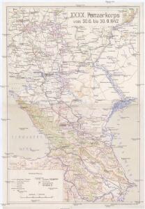
XXXX. Panzerkorps vom 30. 6. bis 30. 9. 1942
1 : 2500000 Kavkaz-oblast Korpskartenstelle
22-23. RSFSR in Europe, South. Georgian SSR, Azerbaijan SSR, Armenian SSR. The World Atlas.
1 : 3000000 USSR (Union of Soviet Socialist Republics).
[Ost-Europa, Blatt 6]
Adolf Stieler's Handatlas über alle Theile der Erde und über das Weltgebäude Stieler, Adolf Justus Perthes
Ost-Europa, No. 6: Sud-Russland & Kaukasien.
1 : 3700000 Petermann, A.
[Ost-Europa in 6 Blättern, enthaltend: Norwegen, Schweden, Russland, Kaukasien und die Türkei, Blatt 6]
Hand-Atlas über alle Theile der Erde und über das Weltgebäude Stieler, Adolf Justus Perthes
Pontus Euxinus et quae adjacent
1 : 4440000 Bospor (Turecko : průliv) Spruner, Karl von Justus Perthes
[Ost-Europa in 6 Blättern, Blatt 6]
Handatlas über alle Theile der Erde und über das Weltgebäude Stieler, Adolf Justus Perthes
Süd-Russland und Kaukasien
1 : 3500000 Kavkaz-oblast J. Schlacher
Das Deutschtum II. 2.
Schwarzmeer-Gebiet Ethnische Gruppe, Deutsche
Carte des environs de la Mer-Noire où se trouvent l'Ukrayne, la Petite Tartarie, la Circassie, la G
1 : 2500000 1 Karte auf 2 Blatt : Kupferdruck ; 50 x 92 cm Robert de Vaugondy, Didier chez Delamarche rue du Foin près celle de la Harpe au collége de M.e Gervais
Nova et accurata Tartariae europaeae seu minoris et in specie Crimeae delineatio geographica / manu
1 : 2900000 1 Karte : Kupferdruck ; 48 x 56 cm [Matthäus Seutter]
Charte der Laender am Caucasus nach den besten vorhandenen
1 : 2100000 Reinecke, J. C. M. (Johann Christoph Matthias), 1770-1818 Im Verlage des Industrie Comptoirs
Die Völker des Kaukasus u.s.w. / gezeichnet u. gestochen in der geogr. Kunstschule zu Potsdam
1 : 2900000 1 Karte : Kupferdruck ; 31 x 39 cm Berghaus, Heinrich Karl Wilhelm J. Perthes
Uebersichts Karte der Russischen Provinzen nördlich und südlich vom Kaukasus
1 : 2500000 München : in der literarisch artistischen Anstalt
Uebersichts Karte der russischen Provinzen nördlich und südlich vom Kaukasus
1 : 2900000 1 Karte : Kupferdruck ; 42 x 47 cm in der literarisch artistischen Anstalt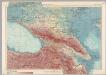
U.S.S.R. - Caucasia. Pergamon World Atlas.
1 : 2500000 Polish Army Topography Service
Carte générale du pays entre les mers Noire et Caspienne
1 : 2300000 Kaspické moře-oblast Darmet, J.M. Damas, Ange Hyacinthe Maxence de
Taurica Chersonesus, Hodie Przecopsca, et Gazara dicitur. [Karte], in: Novus atlas absolutissimus, Bd. 1, S. 113.
1 Karte aus Atlas Janssonius Offizin
Nowaja Semlja zum Gouv. Archangelsk gehörig
1 : 8000000 1 Karte : Lithographie ; 26 x 19 cm Schlieben, W.E.A. von [Georg Joachim Göschen]
Uebersichts Karte der russischen Provinzen nördlich und südlich vom Kaukasus
1 : 2900000 Kavkaz (pohoří : oblast) Literarisch artistische Anstalt
Russia 9.
1 : 3421400 Letts, Son & Co.
Russia in Europe Part IX and Georgia.
1 : 3500000 Society for the Diffusion of Useful Knowledge (Great Britain)
Russia in Europe part IX and Georgia / published under the superintendence of the Society for the Di
1 : 3500000 1 Karte : Kupferdruck ; 31 x 38 cm Walker, John by Baldwin and Cradock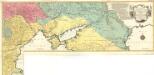
Carte Geographique representant le Théatre de la Guerre entre les Russes les Turcs, et les Polonois Confédérés
1 : 1600000 Mollova mapová sbírka Lotter, Tobias Conrad Lotter, Georg F. Lotter, Tobias Conrad
Sibérie ou Russie asiatique, Tartarie chinoise, pays des Eluts et isles du Japon / Par le Sr. Rober
1 : 21400000 1 Karte : Kupferdruck ; 22 x 29 cm Dussy, E. [Delamarche]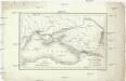
Carte du pourtour septentrional de la Mer Noire
1 : 5000000 Černé moře-oblast Lapie, Pierre Arnoul Firmin Didot
General Charte der Laender Zwischen dem Schwarzen und Caspischen Meere : Circassien, Georgien, Armenien, Wüste von Astrachan und Caucasus hauptsoechlich die Grosse und Kleine Kabarda
1 : 1750000 Treuttel, Jean-Georges, 1744-1826 Joh. Georg Treuttel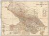
Karta Kavkazskago kraja
1 : 1080000 Baku (Ázerbájdžán) izdanie Kartografičeskago zavedenija A. Il'jina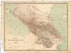
Karta Kavkazskago kraja
1 : 1080000 Kavkaz (pohoří : oblast) Kartografičeskago zavedenija A. Il'jina