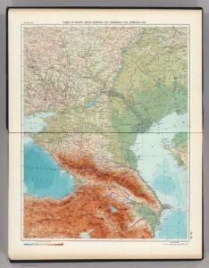
Maps of Caucasus Mountains

22-23. RSFSR in Europe, South. Georgian SSR, Azerbaijan SSR, Armenian SSR. The World Atlas.
1 : 3000000 USSR (Union of Soviet Socialist Republics).
XXXX. Panzerkorps vom 30. 6. bis 30. 9. 1942
1 : 2500000 Kavkaz-oblast Korpskartenstelle
Uebersichts Karte der russischen Provinzen nördlich und südlich vom Kaukasus
1 : 2900000 1 Karte : Kupferdruck ; 42 x 47 cm in der literarisch artistischen Anstalt
Ost-Europa, No. 6: Sud-Russland & Kaukasien.
1 : 3700000 Petermann, A.
Uebersichts Karte der Russischen Provinzen nördlich und südlich vom Kaukasus
1 : 2500000 München : in der literarisch artistischen Anstalt
Uebersichts Karte der russischen Provinzen nördlich und südlich vom Kaukasus
1 : 2900000 Kavkaz (pohoří : oblast) Literarisch artistische Anstalt
Russia 9.
1 : 3421400 Letts, Son & Co.
Russia in Europe Part IX and Georgia.
1 : 3500000 Society for the Diffusion of Useful Knowledge (Great Britain)
Russia in Europe part IX and Georgia / published under the superintendence of the Society for the Di
1 : 3500000 1 Karte : Kupferdruck ; 31 x 38 cm Walker, John by Baldwin and Cradock
[Ost-Europa in 6 Blättern, Blatt 6]
Handatlas über alle Theile der Erde und über das Weltgebäude Stieler, Adolf Justus Perthes
[Ost-Europa in 6 Blättern, enthaltend: Norwegen, Schweden, Russland, Kaukasien und die Türkei, Blatt 6]
Hand-Atlas über alle Theile der Erde und über das Weltgebäude Stieler, Adolf Justus Perthes
[Ost-Europa, Blatt 6]
Adolf Stieler's Handatlas über alle Theile der Erde und über das Weltgebäude Stieler, Adolf Justus Perthes
Charte der Laender am Caucasus nach den besten vorhandenen
1 : 2100000 Reinecke, J. C. M. (Johann Christoph Matthias), 1770-1818 Im Verlage des Industrie Comptoirs
Süd-Russland und Kaukasien
1 : 3500000 Kavkaz-oblast J. Schlacher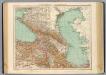
73-74. Caucasia, Mar Caspio.
1 : 3000000 Touring club italiano
(Europaischen Russland IV).
1 : 5000000 Berghaus, Heinrich; Flemming, Carl; Handtke, Friedrich H.; Sohr, Karl
Ostrussland
1 : 2000000 Rusko Kartographische Anstalt Freytag-Berndt u. Artaria
[XV], uit: Geognostische Karte des Oesterreichischen Kaiserstaates mit einem grossen Theile Deutschland's u. Italien / hauptsachlich nach ... Haidinger's geognostischer Karte dieses Staates bearb. von Josef Scheda
1 : 3000000 titelvariant: General-Karte von Europa in 25 Blättern; Annotatie: Bijlage bij: General-Karte von Europa in 25 Blättern. - 1:2.592.000. - 1845-1847 Scheda, Joseph Wien : K.K. Militär. Geografisch. Institut
Pontus Euxinus et quae adjacent
1 : 4440000 Bospor (Turecko : průliv) Spruner, Karl von Justus Perthes
Sibérie ou Russie asiatique, Tartarie chinoise, pays des Eluts et isles du Japon / Par le Sr. Rober
1 : 21400000 1 Karte : Kupferdruck ; 22 x 29 cm Dussy, E. [Delamarche]
Russia at the Caucasus.
1 : 3380000 Sharpe, J.
Geologičeskaja karta Evropejskoj Rossii
1 : 2500000 Südost-Blatt Karpinskij, A.P. (Aleksandr Petrovič) Kartografičeskoe zavedenie A.Il'ina
Carte générale du pays entre les mers Noire et Caspienne
1 : 2300000 Kaspické moře-oblast Darmet, J.M. Damas, Ange Hyacinthe Maxence de
Höhenschichtenkarte der Kaukasusländer mit Reiserouten Dr. G. Raddes
1 : 4500000 Radde, Gustav Engelmann
U.S.S.R. - Caucasia. Pergamon World Atlas.
1 : 2500000 Polish Army Topography Service
General Charte der Laender Zwischen dem Schwarzen und Caspischen Meere : Circassien, Georgien, Armenien, Wüste von Astrachan und Caucasus hauptsoechlich die Grosse und Kleine Kabarda
1 : 1750000 Treuttel, Jean-Georges, 1744-1826 Joh. Georg Treuttel
Charte der Laender am Caucasus
1 : 2200000 Kavkaz-oblast Reinecke, Johann Christoph Matthias
Charte der Laender am Caucasus
1 : 2200000 Kavkaz-oblast Reinecke, Johann Christoph Matthias
Die Volker des Kaukasus U.S.W.
1 : 3000000 Berghaus, Heinrich