Maps of Caucasus Mountains

General Charte der Laender Zwischen dem Schwarzen und Caspischen Meere : Circassien, Georgien, Armenien, Wüste von Astrachan und Caucasus hauptsoechlich die Grosse und Kleine Kabarda
1 : 1750000 Treuttel, Jean-Georges, 1744-1826 Joh. Georg Treuttel
Uebersichts Karte der russischen Provinzen nördlich und südlich vom Kaukasus
1 : 2900000 1 Karte : Kupferdruck ; 42 x 47 cm in der literarisch artistischen Anstalt
Uebersichts Karte der Russischen Provinzen nördlich und südlich vom Kaukasus
1 : 2500000 München : in der literarisch artistischen Anstalt
Uebersichts Karte der russischen Provinzen nördlich und südlich vom Kaukasus
1 : 2900000 Kavkaz (pohoří : oblast) Literarisch artistische Anstalt
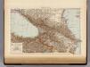
Russia at the Caucasus.
1 : 3380000 Sharpe, J.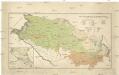
Mapa ruské národnosti na severním Kavkazsku
1 : 1080000 Kavkaz-oblast Chotek, Karel Česká společnost zeměvědná
Russia 9.
1 : 3421400 Letts, Son & Co.
Russia in Europe Part IX and Georgia.
1 : 3500000 Society for the Diffusion of Useful Knowledge (Great Britain)
Russia in Europe part IX and Georgia / published under the superintendence of the Society for the Di
1 : 3500000 1 Karte : Kupferdruck ; 31 x 38 cm Walker, John by Baldwin and Cradock
Charte der Laender am Caucasus
1 : 2100000 Kavkaz (pohoří : oblast) Reinecke, Johann Christoph Matthias
CHARTE der LAENDER AM CAUCASUS
1 : 2100000 Kavkaz-oblast Reinecke, Johann Christoph Matthias
Charte der Laender am Caucasus
1 : 2700000 Kavkaz-oblast Reinecke, Johann Christoph Matthias im Verlage des Geograph. Institut
Charte der Laender am Caucasus
1 : 2700000 Kavkaz-oblast Reinecke, Johann Christoph Matthias Geograph. Institut
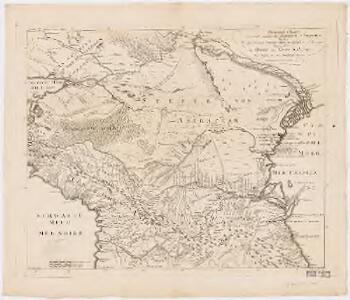
Carte générale du pays entre les mers Noire et Caspienne
1 : 2300000 Kaspické moře-oblast Darmet, J.M. Damas, Ange Hyacinthe Maxence de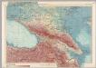
U.S.S.R. - Caucasia. Pergamon World Atlas.
1 : 2500000 Polish Army Topography Service
Sbornyje list 5-ti verstnoj karty Kavkaza
1 : 1778000 Kavkaz (pohoří : oblast)
Charte der Laender am Caucasus
1 : 2200000 Kavkaz-oblast Reinecke, Johann Christoph Matthias
Charte der Laender am Caucasus
1 : 2200000 Kavkaz-oblast Reinecke, Johann Christoph Matthias
Die Volker des Kaukasus U.S.W.
1 : 3000000 Berghaus, Heinrich
Die Völker des Kaukasus u.s.w. / gezeichnet u. gestochen in der geogr. Kunstschule zu Potsdam
1 : 2900000 1 Karte : Kupferdruck ; 31 x 39 cm Berghaus, Heinrich Karl Wilhelm J. Perthes
Höhenschichtenkarte der Kaukasusländer mit Reiserouten Dr. G. Raddes
1 : 4500000 Radde, Gustav Engelmann
Die Völker des Kaukasus, Grusien's und des Armenischen Hochlandes
Zweiter Band, enthaltend in vier Abtheilungen die Vertheilung der Organismen: 5. Pflanzen-Geographie, 6. Thier-Geographie, 7. Anthropographie, 8. Ethnographie Humboldt, Alexander von Verlag von Justus Perthes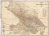
Karta Kavkazskago kraja
1 : 1080000 Baku (Ázerbájdžán) izdanie Kartografičeskago zavedenija A. Il'jina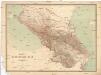
Karta Kavkazskago kraja
1 : 1080000 Kavkaz (pohoří : oblast) Kartografičeskago zavedenija A. Il'jina
Karta teatra vojny s Turcieju
1 : 350000 1 Karte : mehrfarbig ; 56 x 80 cm Kartograf. zavod A. Ilʹina
Karte für die Niederschlagsverhältnisse und die Verbreitung der wichtigsten Holzgewächse in den Kaukasusländern
1 : 4500000 Radde, Gustav Engelmann
Pays du Caucase
Nouvel atlas physique politique et historique de l'Empire ottoman et des états limitrophes en Europe, en Asie et en Afrique, en quarante feuilles Hellert, J.J. Bellizard, Dufour et Cie
Kaukasus.
1 : 2600000 Grassl, J. (Joseph)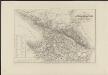
Carte des possessions russes au-delà du Caucase indiquant les frontières actuelles de la Russie, de la Turquie et de la Perse, dressée sur des documents officiels
1 : 750000 gravé sur pierre [par Alex. Zakrzewski] Imp. Lith. de Thierry Paris : A. Leneveu