Maps of Caucasus Mountains
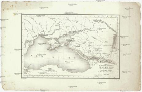
Carte du pourtour septentrional de la Mer Noire
1 : 5000000 Černé moře-oblast Lapie, Pierre Arnoul Firmin Didot
Das Deutschtum II. 2.
Schwarzmeer-Gebiet Ethnische Gruppe, Deutsche
Pontus Euxinus et quae adjacent
1 : 4440000 Bospor (Turecko : průliv) Spruner, Karl von Justus Perthes
Carte des environs de la Mer-Noire où se trouvent l'Ukrayne, la Petite Tartarie, la Circassie, la G
1 : 2500000 1 Karte auf 2 Blatt : Kupferdruck ; 50 x 92 cm Robert de Vaugondy, Didier chez Delamarche rue du Foin près celle de la Harpe au collége de M.e Gervais
Reliefkarte des Schwarzen Meeres, einschließlich der Dardanellen und der Kaukasus
Dardanely (Turecko : průliv) Franckh'sche Verlagshandlung
Carte de la partie septentrionale de l'Empire Otoman
1 : 1420000 osmanská říše Rizzi Zannoni, Giovanni Antonio Arrivet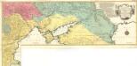
Carte Geographique representant le Théatre de la Guerre entre les Russes les Turcs, et les Polonois Confédérés
1 : 1600000 Mollova mapová sbírka Lotter, Tobias Conrad Lotter, Georg F. Lotter, Tobias Conrad
Süd-Russland und Kaukasien
1 : 3500000 Kavkaz-oblast J. Schlacher
Taurica Chersonesus, Nostra aetate Przecopsca, et Gazara dicitur. [Karte], in: Novus Atlas, das ist, Weltbeschreibung, Bd. 1, S. 66.
1 Karte aus Atlas Blaeu, Joan Blaeu, Willem Janszoon
Nova et accurata Tartariae europaeae seu minoris et in specie Crimeae delineatio geographica / manu
1 : 2900000 1 Karte : Kupferdruck ; 48 x 56 cm [Matthäus Seutter]
Pontos Euxeinos / ex conitabus geographicis Abrahami Ortelij
1 : 3750000 1 Karte : Kupferdruck ; 35 x 50 cm Ortelius, Abraham [Officina Plantiniana]
The Black Sea and surronding countries”
1 mapa. Datat entre 1840 i 1849. Hughes, William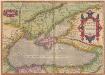
Pontus Euxinus. Aequor Iasonis pulsarum, remige primum. [Karte], in: Theatrum orbis terrarum, S. 413.
1 Karte aus Atlas Ortelius, Abraham
Pontus Euxinus of Niewe en naaukeurige paskaart van de Zwarte Zee
1 Karte : Kupferdruck ; 40 x 58 cm Renard; Witsen apud L. Renard
Schwarze Meer, Kustenlander.
1 : 4150000 Radefeld, Carl Christian Franz, 1788-1874

Oorlogskaart van Turkije, Zuid-Rusland en grenslanden
1 : 2250000 Annotatie: Westelijk deel van de kaart ontbreekt Amsterdam : Seyffardt
Nova mappa maris nigri et freti Constantinopolitani
1 Karte : Kupferdruck ; 47 x 56 cm Lotter Tobias Konrad Lotter
Nouvelle carte de la petite Tartarie ou Taurie, montrant les frontieres de l'Imperatrice de Russie, et l'Empereur des Turcs, tant en Europe qu'en Asie
1 : 2750000 composée sur les observations les plus nouvelles A Amsterdam : chez Elwe & Langeveld
Russia on the Euxine (Black Sea).
1 : 3380000 Sharpe, J.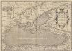
Pontus Euxinus. Aequor Iasonio pulsatum remige primum. [Karte], in: Theatrum orbis terrarum, S. 508.
1 Karte aus Atlas Ortelius, Abraham Vrients, Jan Baptista
Theatre de la guerre dans la Petite Tartarie, la Crimée, la mer Noire, &c
1 Karte auf 2 Blatt : Kupferdruck ; 91 x 60 cm L'Isle chez Jean Cóvens et Corneille Mortier géographes
Theatre de la guerre dans la Petite Tartarie, la Crimée, la mer Noire, &c. / dressée sur un grand
1 : 1300000 1 Karte auf zwei Blatt : Kupferdruck ; 91 x 60 cm L'Isle, Guillaume de chez Jean Cóvens et Corneille Mortier géographes
Tartaria in Europe / by Robt. Morden
1 : 11100000 1 Karte : Kupferdruck ; 11 x 13 cm Morden, Robert [Printed for Robert Morden and Thomas Cockerill]

Neueste Karte der Küstenländer des Schwarzen Meeres
1 : 4180000 Černé moře-oblast Radefeld, Carl Christian Franz Verlag des Bibliographischen Instituts
Neueste Karte der Küstenländer des Schwarzen Meeres
1 : 4180000 Černé moře-oblast Radefeld aus der Geograph. Graviranstalt des Bibliograph. Instituts
Neueste Karte der Küstenländer des Schwarzen Meeres
Grosser Hand-Atlas über alle Theile der Erde in 170 Karten Meyer, J. Verlag des Bibliographischen Instituts
Nowaja Semlja zum Gouv. Archangelsk gehörig
1 : 8000000 1 Karte : Lithographie ; 26 x 19 cm Schlieben, W.E.A. von [Georg Joachim Göschen]