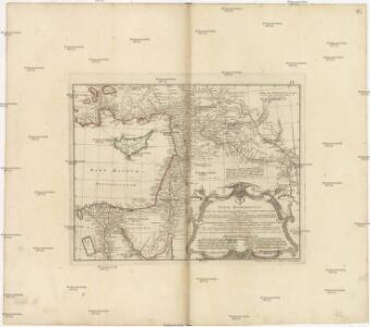
Maps of Mesopotamia
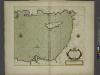
Typvs AEtiologicvs
1 : 3900000 Blízký východ Hase, Johann Matthias Luca, Paulus in officina Homan[n]iana
Typvs AEtiologicvs
1 : 3900000 Blízký východ Hase, Johann Matthias Luca, Paulus in officina Homan[n]iana
[Blízký východ-starověk]
starověký Egypt Kiepert, Heinrich Arnd
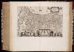
REGNI DAVIDICI et SALOMONAEI Descriptio Geographica
1 : 3600000 Egypt Hase, Johann Matthias in officina Homan[n]iana
Regni Davidici et Salomonaei descriptio geographica
1 : 3600000 Egypt Hase, Johann Matthias in officina Homan[n]iana
Places Recorded in the Five Books of Moses.
1 : 4700000 Finley, Anthony
149-150. East Mediterranean Lands and Iraq. Baghdad. The World Atlas.
1 : 2500000 USSR (Union of Soviet Socialist Republics).
Abraham Patriarchae Peregrinatio, Et Vita. [Karte], in: Theatrum orbis terrarum, S. 445.
1 Karte aus Atlas Ortelius, Abraham
Asie occidentale
1 : 2000000 Asie východní Castelnau, Paul Hatier
Abrahami Patriarchae Peregrinatio, Et Vita. [Karte], in: Theatrum orbis terrarum, S. 444.
1 Karte aus Atlas Ortelius, Abraham Vrients, Jan Baptista
Places Recorded in the Five Books of Moses. (1826)
1 : 4600000 Tanner, Henry S.
Carte de la Syrie
Nouvel atlas physique politique et historique de l'Empire ottoman et des états limitrophes en Europe, en Asie et en Afrique, en quarante feuilles Hellert, J.J. Bellizard, Dufour et Cie
Carte de la situation du paradis terrestre, et des pais habitez par les patriarches
1 : 5000000 Blízký východ Huet, Pierre-Daniel Mortier, Pieter chez Pierre Mortier
General - Karte von Europa mit Klein - Asien und dem nördlichen Afrika
A chart of the LEVANT or the sea coast of Egypt, Syria, Caramania and the Island Cyprus
from The sea-atlas : containing an hydrographical description of most of the sea-coasts of the known parts of the world.
Syria and the Provinces to the Persian Gulf.
1 : 3380000 Sharpe, J.
Perigrinatie ofte veertich-jarige reyse der Kinderen Israëls, uyt Egypten door de Roode Zee, ende de Woestyne, tot in 't Beloofde Landt Canaan / met groote verbeteringe van nieuws geteeckent en uytgegeven door Nicolaus Visscher ; A. van den Broeck fecit
1 : 1500000 Annotatie: In rechteronderhoek, rechts naast putto, onder naam graveur A. van den Broeck: 3; Vermelding boven uitgeversnaam C.J. Visscher: "Deze Caerte wert gestelt voor het 33. Capittel Numeri"; Origineel is Blad 185 in atlas factice; Met afbeeldingen van religieuze attributen; Annotatie geografische gegevens: Schaalstok: 20 Uren-gaens yder inhoudende 24 Stadien dat is 3000 Passen; West boven; Inzet: Afbeeldinge van 't Leger Israëls na de Ordinantie Godts treckende door de Woestyne na 't Beloofde Landt Canaan Nicolaes Jansz Visscher sr 1618-1679; Abraham van den Broeck ca. 1616-1688 [S.l. : C.J. Visscher excud]
Assyria vetvs divisa in Syriam, Mesopotamiam Babyloniam, & Assyriam proprie dictam
Asýrie La Rue, Philippe de Mortier, Pieter apud Pet. Mortier
Euphrates Valley, Syria, Kurdistan &c.
1 : 3220177 Stanford, Edward
L'ancienne Thebaide ou les deserts d'Egypte habitez par les S.s Peres des deserts
1 : 3630000 Egypt Mortier, Pieter chez Pierre Mortier
Syria to Sinai.
1 : 2200000 Society for the Diffusion of Useful Knowledge (Great Britain)
Afbeelding van 't Koningryk Israëls, benevens de door 't zelve overheerde landen; gedurende de regering der koningen Saul, David, en Salomo
1 : 2300000 door W.A. Bachiene J. van Jagen mapp. sculpsit, et figur. apposit. sculpturam curavit ; J. Folkema f. Uitgegeven te Gorinchem : by Nicolaas Goetzee
Ancient Syria
1 : 2200000 Blízký východ Hughes, William Chapman & Hall
Situs Terrae Promissionis. S.S. Bibliorum intelligentiam exacte aperiens [Karte], in: Gerardi Mercatoris et I. Hondii Newer Atlas, oder, Grosses Weltbuch, Bd. 2, S. 347.
1 Karte aus Atlas Mercator, Gerhard und Hondius, Jodocus Jansson, Jan
Syrien u. Aegypten
[Allgemeiner Atlas über alle Theile der Erde in 29 Blättern] Ziegler, Jakob Melchior Top. Anstalt v. J. Wurster u. Comp.
Übersichtskarte Konya-Kairo
1 : 1000000 Gen St d H Abt f Kr Kart u Verm Wes
[Syrien und Aegypten]
Hypsometrischer Atlas Ziegler, Jakob Melchior Topogr. Anstalt v. J. Wurster u. Comp.
Situs Terrae Promissionis. S.S. Bibliorum intelligentiam exacte aperiens [Karte], in: Novus atlas absolutissimus, Bd. 6, S. 108.
1 Karte aus Atlas Janssonius Offizin