Maps of Iraq

[Blízký východ-starověk]
starověký Egypt Kiepert, Heinrich Arnd
Quarta Asiae Tabula [Karte], in: Claudii Ptolemei viri Alexandrini mathematice discipline philosophi doctissimi geographie opus [...], S. 202.
1 Karte aus Atlas Waldseemüller, Martin [und Ptolemaeus, Claudius] Übelin, Georg
Quarta Asie Tabula [Karte], in: [Clavdii Ptholomei Cosmographi ...], S. 308.
1 Karte aus Atlas Nicolaus Germanus [und Ptolemaeus, Claudius]
L'Euphrate et le Tigre
1 : 2400000 Anville, Jean Baptiste Bourguignon d', 1697-1782 [s.n.]
Asie Anterieure.
1 : 5000000 Vivien St Martin, L.
Carte de la situation du paradis terrestre, et des pais habitez par les patriarches
1 : 5000000 Blízký východ Huet, Pierre-Daniel Mortier, Pieter chez Pierre Mortier
Karte von Klein Asien
1 : 5700000 Malá Asie Radefeld, C. Biedermann, E. aus der Geograph. Graviranstalt des Bibliograph. Instituts
Karte von Klein Asien
Grosser Hand-Atlas über alle Theile der Erde in 170 Karten Meyer, J. Verlag des Bibliographischen Instituts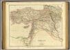
Turkey in Asia.
1 : 3440000 Arrowsmith, John
149-150. East Mediterranean Lands and Iraq. Baghdad. The World Atlas.
1 : 2500000 USSR (Union of Soviet Socialist Republics).
Afbeelding van alle de landen gelegen tusschen de Middellandsche, Zwarte, Caspische, Persische en Rode Zeeën : benevens derzelver rivieren, bergen, berugtste steden enz. : alles met derzelver aloude namen uitgedrukt, zo als verstrekt tot opheldering van de aards-vaderlyke geschiedenis
1 : 4000000 door W.A. Bachiene J. van Jagen sculp. 1747 ; J. Punt inv. et fecit. Uitgegeven te Gorinchem : by Nicolaas Goetzee
Euphrates Valley, Syria, Kurdistan &c.
1 : 3220177 Stanford, Edward
Turkey in Asia.
1 : 5800000 Mitchell, Samuel Augustus
Turkey in Asia.
1 : 5800000 Mitchell, Samuel Augustus
Turkey in Asia.
1 : 6000000 Tanner, Henry S.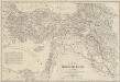
Karte des Türkischen Reichs in Asien
1 : 2500000 nach den besten und neuesten Hülfsmitteln vorzüglich nach der Aufnahme-Karte von Klein-Asien und Kurdistan von v. Vincke, Fischer, v. Moltke und Kiepert, der Aufnahme des Euphrat und Tigris von Chesney und Lynch, der Monteith'shen Karte von Kurdistan, sowie den neusten Reiseberichten von Hamilton, Ainsworth, Brant, Koch, Schönborn u.a. entworfen und gezeichnet von H. Kiepert Stich und Druck von H. Delius Berlin : Schropp
Turkey In Asia.
1 : 7603200 Tallis, J. & F.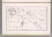
Asiatic Turkey. Coal Resources of the World.
1 : 6336000 McInnes, William; Leach, W.W.; Dowling, D.B.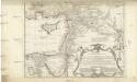
Typvs AEtiologicvs
1 : 3900000 Blízký východ Hase, Johann Matthias Luca, Paulus in officina Homan[n]iana
Typvs AEtiologicvs
1 : 3900000 Blízký východ Hase, Johann Matthias Luca, Paulus in officina Homan[n]iana
Syria and the Provinces to the Persian Gulf.
1 : 3380000 Sharpe, J.
Assyria vetvs divisa in Syriam, Mesopotamiam Babyloniam, & Assyriam proprie dictam
Asýrie La Rue, Philippe de Mortier, Pieter apud Pet. Mortier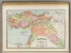
Turkey in Asia.
1 : 7603200 Rand McNally and Company
Turkey In Asia.
1 : 5900000 Mitchell, Samuel Augustus
Turkey In Asia.
1 : 6000000 Tanner, Henry S.
Turkey In Asia.
1 : 6000000 Tanner, Henry S.
Turkey, Israel, Cyprus, Lebanon, Syria, Iraq, Jordan. Pergamon World Atlas.
Polish Army Topography Service
Assyrie, Babylonie a Persie

Das Osmanische Reich in Asien (Klein-Asien, Armenien, Kurdistan, Mesopotamien, Syrien)
Hand-Atlas über alle Theile der Erde nach dem neuesten Zustande und über das Weltgebäude Stieler, Adolf bei Justus Perthes
![[Blízký východ-starověk]](https://images-2.georeferencer.com/images/iiif/478571837384/full/,300/0/native.jpg)

