Maps of Fejér

Fejér válmegye
1 : 370000 Fejér (Maďarsko) Chiapó, Benjamin Benedicti, Hieronymus
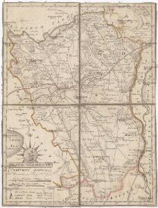
Comitat Stuhlweissenburg
1 : 300000
Comitat Stuhlweissenburg
1 : 280000 Székesfehérvár (Maďarsko)

C. Albensis
Ungarn Fejér
Fejér vármegye térképe
1 : 380000 Fejér (Maďarsko) Kogutowicz, Manó Magyar Földrajzi Intézet
Stuhlweissenburg 162, uit: Special-Karte von Mittel-Europa / nach amtlichen Quellen bearbeitet von W. Liebenow
1 : 300000 titelvariant: W. Liebenow's Mittel-Europa; Annotatie: Titel boven de bladen: W. Liebenow's Mittel-Europa Johannes Wilhelm Liebenow 1822-1897 Frankfurt a. M. : Ludwig Ravenstein
Stoni Beograd
1 : 200000 Székesfehérvár (Maďarsko) Generalštab
C. Pilisiensis ; C. Solthensis
Ungarn Komitat Pest-Pilis-Solt-Kiskun
Bicske und Martonvasar.
from Spezialkarte der osterreichisch-ungarischen Monarchie.
Sarbogard.
from Spezialkarte der osterreichisch-ungarischen Monarchie.
Szekesfehervar und Seregelyes.
from Spezialkarte der osterreichisch-ungarischen Monarchie.
Stuhlweissenburg
1 : 75000 Székesfehérvár
Bicske
1 : 75000 Bicske, Fejér
Sárbogárd
1 : 75000 Sárbogárd, Umland
Balatonfured und Varos-Hidveg.
from Spezialkarte der osterreichisch-ungarischen Monarchie.
Moor und Zircz.
from Spezialkarte der osterreichisch-ungarischen Monarchie.
Veszprem und Varpalota (Ungarn).
from Spezialkarte der osterreichisch-ungarischen Monarchie.
Budapest und Teteny.
from Spezialkarte der osterreichisch-ungarischen Monarchie.
Dunaadony und Kunszentmiklos.
from Spezialkarte der osterreichisch-ungarischen Monarchie.
Balaton-Füred
1 : 75000 Balatonfüred, Umland
Moór
1 : 75000 Mór, Fejér
Dunafoldvar und Szabadszallas.
from Spezialkarte der osterreichisch-ungarischen Monarchie.
Neszmely und Zsambek.
from Spezialkarte der osterreichisch-ungarischen Monarchie.
Dunaföldvár
1 : 75000 Dunaföldvár, Dunaföldvár (Region)
Rác-Adony
1 : 75000 Adony, Adony (Region)
2 Ofen-Pest
Budapest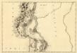
St. Andre - Ertsin
Mollova mapová sbírka Marsili, Luigi Ferdinando
III. vojenské mapování 4961
1 : 75000
Radvaň n. Dunajom
1 : 75000 Maďarsko Vojenský zeměpisný ústav
Zsámbék
1 : 75000 Maďarsko Vojenský zeměpisný ústav