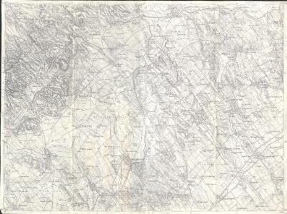
Maps of Bicskei járás
Bicske
1 : 75000 Bicske, Fejér
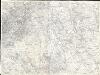
Bicske und Martonvasar.
from Spezialkarte der osterreichisch-ungarischen Monarchie.
Fejér vármegye térképe
1 : 380000 Fejér (Maďarsko) Kogutowicz, Manó Magyar Földrajzi Intézet
C. Albensis
Ungarn Fejér
Comitat Stuhlweissenburg
1 : 300000
Comitat Stuhlweissenburg
1 : 280000 Székesfehérvár (Maďarsko)

Fejér válmegye
1 : 370000 Fejér (Maďarsko) Chiapó, Benjamin Benedicti, Hieronymus

C. Strigontensis
Ungarn Komitat Gran (Ungarn)
Stoni Beograd
1 : 200000 Székesfehérvár (Maďarsko) Generalštab
Komorn 148, uit: Special-Karte von Mittel-Europa / nach amtlichen Quellen bearbeitet von W. Liebenow
1 : 300000 titelvariant: W. Liebenow's Mittel-Europa; Annotatie: Titel boven de bladen: W. Liebenow's Mittel-Europa Johannes Wilhelm Liebenow 1822-1897 Frankfurt a. M. : Ludwig Ravenstein
Stuhlweissenburg 162, uit: Special-Karte von Mittel-Europa / nach amtlichen Quellen bearbeitet von W. Liebenow
1 : 300000 titelvariant: W. Liebenow's Mittel-Europa; Annotatie: Titel boven de bladen: W. Liebenow's Mittel-Europa Johannes Wilhelm Liebenow 1822-1897 Frankfurt a. M. : Ludwig Ravenstein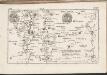
C. Pilisiensis ; C. Solthensis
Ungarn Komitat Pest-Pilis-Solt-Kiskun
Neszmely und Zsambek.
from Spezialkarte der osterreichisch-ungarischen Monarchie.
Szekesfehervar und Seregelyes.
from Spezialkarte der osterreichisch-ungarischen Monarchie.
Moor und Zircz.
from Spezialkarte der osterreichisch-ungarischen Monarchie.
Budapest und Teteny.
from Spezialkarte der osterreichisch-ungarischen Monarchie.
2 Ofen-Pest
Budapest
Veleceitó és Környéke
1 : 25000 Székesfehérvár (Maďarsko) M. Kir. Állami Térképészet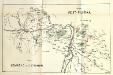
Stolice Pešť-Pilišská. Stolice Komárno a Ostřihom
Komitat Komárom-Esztergom, Komitat Pest-Pilis-Solt-Kiskun, ethnische Gruppe
Bez titulu: Západní Maďarsko
Siedlungsgebiet der Deutschen nach dem Nachbarschaftsindex für Mittel-Transdanubien 1980
Ungarn, Zentralungarn, Deutsche, Siedlung Bottlik, Zsolt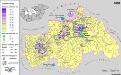
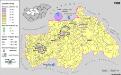
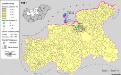
Siedlungsgebiet der Deutschen nach dem Nachbarschaftsindex für Mittel-Transdanubien 1880
Ungarn, Zentralungarn, Deutsche, Siedlung Bottlik, Zsolt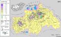
Siedlungsgebiet der Deutschen nach dem Nachbarschaftsindex für Mittel-Transdanubien 1941
Ungarn, Zentralungarn, Deutsche, Siedlung Bottlik, Zsolt
Bez titulu: Přehledná mapa střední Evropy
Siedlungsgebiet der Slowaken nach dem Nachbarschaftsindex für Mittel-Transdanubien 1941
Ungarn, Zentralungarn, Slowaken, Siedlung Bottlik, Zsolt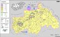
A németek településterülete a szomszédsági mutató alapján Közép-Dunántúlon 1980-ban
Ungarn, Zentralungarn, Deutsche, Siedlung Bottlik, Zsolt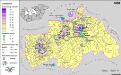
A németek településterülete a szomszédsági mutató alapján Közép-Dunántúlon 1880-ban
Ungarn, Zentralungarn, Deutsche, Siedlung Bottlik, Zsolt