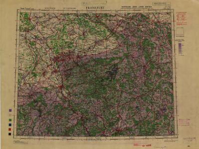
Maps of Nordrhein-Westfalen
1:500,000 Europe (Air) G.S.G.S. No. 4072, Frankfurt
Sheet NE50-6 from the map series: 1:500,000 Europe (Air) G.S.G.S. No. 4072.
Die Preussische Provinz Sachsen
1 : 600000 Geographisches Institut (Weimar, Germany)
Operationen der alliirten und französischen Armee 1759

Charte von den Grosherzogthümern Berg und Hessen, den Fürstlich-Primatischen Laendern; dem Herzogthume Nassau und den übrigen darinne begränzten, zum Theil noch uneingetheilten Laendern
1 : 820000 Streit, Friedrich Wilhelm Verl. des Geograph. Inst.
[Vestfálsko]
Vestfálsko (Německo)
Operations-Karte für die Bewegung der alliirten und der ihr gegenüberstehenden Französischen Armee vom 7ten Februar bis 8ten März.
1 : 600000
Deutsch - Französischen Kriegsschauplatzes

Geologische Übersichtskarte der Rheinprovinz und der Provinz Westfalen / bearb. von H. von Dechen
1 : 500000 Annotatie: Oorspr. uitg.: 1866 Heinrich von Dechen Berlin : Schropp
Die preussischen Provinzen Westphalen und Rheinprovinz, das Kurfürstenthum Hessen, das Grossherzogthum Hessen und das Herzogthum Nassau, das Fürstenthum Waldeck, die Landgrafschaft Hessen Homburg und die freie Stadt Frankfurt
1 : 540000 Frankfurt nad Mohanem (Německo) Gräf, A. Luther. Th. Geographisches Institut
Estat et Seigneurie de l'Eves.ché de Lyege
1 : 240000 Mollova mapová sbírka Sanson, Guillaume Jaillot, Alexis Hubert
Geographisch-statistische Post- und Resekarte zu den besuchtesten Rhein- und Main-Gegenden
1 : 831500 Mohan (Německo) Bauerkeller, Georg J.P. Streng
Übersichts-Karte der Operationen der allirten und französischen Armee von Eröffnung des Sommerfeldzuges bis zur Schlacht bei Vellinghausen oder vom Anfang Juni bis 15t Juli 1761
1 : 600000
Le cercle de Westphalie
1 : 740000 Vestfálsko (Německo) Jaillot, Alexis-Hubert I. Cóvens et C. Mortier
Geologische Übersichtskarte der Rheinprovinz und der Provinz Westfalen / bearb. von H. von Dechen
1 : 500000 Heinrich von Dechen Berlin : Schropp
Übersichtskarte von Mittel - Europa

Westphalen.
1 : 720000 Flemming, Carl
Übersichtskarte von Mittel - Europa

Cöln, Cassel, Hannover, Osnabrück, Fulda
1 : 750000 Fulda (Německo) Lorenz, K. K. u. k. Militärgeographisches Institut
Cöln, Cassel, Hannover, Osnabrück, Fulda
1 : 750000 Fulda (Německo) K. k. militär-geographisches Institut
Operationen der Alliirten und Französischen Armee 1759

Rhein Provinz.
1 : 825000 Flemming, Carl
Tractvs Rhenanvs Inferior excusus cura
1 : 810000 Mollova mapová sbírka Weigel, Magdalena Esther Weigel, Johann Christoph - vdova

Dioecesis Coloniensis
1 : 650000 Kolín nad Rýnem-oblast (Německo)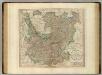
Upper, Lower Rhine circles.
1 : 700000 Cary, John, ca. 1754-1835
Carte de la Westphalie et de la Hesse
Brémy (Německo : spolková země)
Charte von den Königlich Preusischen Provinzen Westphalen, Cleve-Berg und Niederrhein dem Kurfürstenthume Hessen, Grosherzogthume Hessen, dem Herzogth. Nassau, Fürstenth. Waldeck und dem Gebiete der freien Stadt Frankfurt
1 : 1080000 Dolní Porýní (Německo) Weiland, Karl Ferdinand im Verlage des Geograph. Instituts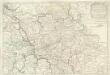
Estats De la Succeßion de Cleves et Iuliers
1 : 860000 Mollova mapová sbírka Sanson, Nicolas Cordier, Robert Sanson, Nicolas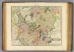
Upper, Lower Rhine.
1 : 720000 Lizars, Daniel
Synopsis circuli Rhenani inferioris sive electorum Rheni
1 : 620000 Porýní-Falc (Německo) Lotter, Tobias Conrad Tobias Conrad Lotter
Synopsis circuli Rhenani inferioris sive electorum Rheni
1 : 620000 Porýní-Falc (Německo) Lotter, Tobias Conrad T. C. Lotter
Synopsis circuli Rhenani inferioris sive electorum Rheni
1 : 620000 Porýní-Falc (Německo) Lotter, Tobias Conrad Tobias Conrad Lotter
SYNOPSIS CIRCULI RHENANI INFERIORIS sive ELECTORUM RHENI
1 : 640000 Porýní-Falc (Německo) Seutter, Matthäus a Matth. Seutter