Maps of North Rhine-Westphalia

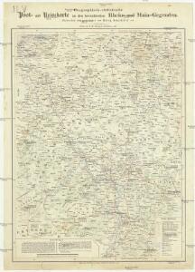
Geographisch-statistische Post- und Resekarte zu den besuchtesten Rhein- und Main-Gegenden
1 : 831500 Mohan (Německo) Bauerkeller, Georg J.P. Streng
Westdeutschland
Volksschul-Atlas über alle Teile der Erde Lange, Henry Druck und Verlag von Georg Westermann
Die Preussische Provinz Sachsen
1 : 600000 Geographisches Institut (Weimar, Germany)
Rhenish Prussia, Westphalia, Hesse-Nassau, Waldeck, Lippe, Hesse.
1 : 1000000 Andree, Richard; Times (London, England)
Charte von den Königlich Preussischen Provinzen Westphalen Cleve-Berg und Niederrhein dem Kurfürstenthume Hessen, Grossherzogthume Hessen, dem Herzogth. Nassau Fürstenth. Waldeck und dem Gebiete der freien Stadt Frankfurt
1 : 800000 entworfen von C. F. Weiland Weimar : im Verlage des Geograph. Instituts
Rheinprovinz, Westfalen, Hessen-Nassau, Waldeck, Grossherzogthum Hessen.
1 : 1000000 Andree, Richard
Le Cercle Eslectorial Du Rhein subdivié entous les Estats qui le composent [Karte], in: Atlas nouveau, contenant toutes les parties du monde [...], Bd. 1, S. 290.
1 Karte aus Atlas Sanson, Nicolas Jaillot, Alexis Hubert und Mortier, Pieter
Die königlich preussische Provinz Westphalen und die Rhein-Provinz, uit: General Charte von dem Koenigreiche Sachsen / nach den besten vorhandenen Hilfsmitteln und nach den neuesten äussern und innern Begränzungen des Königreichs entworfen von C.F. Weiland
1 : 300000 titelvariant: Royaume de Saxe, Pays de Saxe, Provinces du Rhin et Hesse Cassel & Darmstadt; Annotatie: In hoesje met opdruk: Royaume de Saxe, Pays de Saxe, Provinces du Rhin et Hesse Cassel & Darmstadt Weiland, C. F. Weimar : im Verlage des Geographischen Instituts
Westphalen, Rhein-Privinz, Hessen.
1 : 700000 Weiland, C. F. (Carl Ferdinand), d. 1847
Teutschlands Nieder Rheinischer Creiss mit seinen abgetheilten Provintzen
1 : 2600000 Mollova mapová sbírka Weigel, Christoph Weigel, Christoph I.
[Vestfálsko]
Vestfálsko (Německo)

Geologische Übersichtskarte der Rheinprovinz und der Provinz Westfalen / bearb. von H. von Dechen
1 : 500000 Annotatie: Oorspr. uitg.: 1866 Heinrich von Dechen Berlin : Schropp
Geologische Übersichtskarte der Rheinprovinz und der Provinz Westfalen / bearb. von H. von Dechen
1 : 500000 Heinrich von Dechen Berlin : Schropp
Die preussischen Provinzen Westphalen und Rheinprovinz, das Kurfürstenthum Hessen, das Grossherzogthum Hessen und das Herzogthum Nassau, das Fürstenthum Waldeck, die Landgrafschaft Hessen Homburg und die freie Stadt Frankfurt
1 : 540000 Frankfurt nad Mohanem (Německo) Gräf, A. Luther. Th. Geographisches Institut
Tabula Nova Circuli Electoralis Rheni, ad Usum Serenissimi Burgundae Ducis
1 : 670000 Mollova mapová sbírka Jaillot, Alexis-Hubert Ottens, Josua
Tabula Nova Circuli Electoralis Rheni, ad Usum Serenissimi Burgundae Ducis
1 : 670000 Mollova mapová sbírka Jaillot, Alexis-Hubert Jaillot, Alexis Hubert

S. R. I. Rhenanus Inferior sive Electorum Rheni

Der Chur Rheinsiche- oder Nieder Rheinische Kreis
1 : 620000 Porýní-Falc (Německo) Güssefeld, Franz L. bey den Homännischen Erben
Der Chur Rheinsiche- oder Nieder Rheinische Kreis
1 : 620000 Porýní-Falc (Německo) Güssefeld, Franz L. bey den Homännischen Erben

Le Cercle Eslectoral du Rhein subdivisé et touts les Estats qui le composent sur les Memoires le plus Nouveaux
1 : 560000 Mollova mapová sbírka Sanson, Guillaume Cordier, Louis Jaillot, Alexis Hubert
Rhein Provinz.
1 : 825000 Flemming, Carl
S.R.I. circulus Rhenanus inferior sive electorum Rheni
1 : 640000 Dolní Porýní (Německo) Homann, Johann Baptist a Ioh. Baptista Homanno
S.R.I. circulus Rhenanus inferior sive electorum Rheni
1 : 640000 Dolní Porýní (Německo) Homann, Johann Baptist a Ioh. Baptista Homanno
S.R.I. circulus Rhenanus inferior sive electorum Rheni
1 : 640000 Dolní Porýní (Německo) Homann, Johann Baptist a Ioh. Baptista Homanno
S. R. I. circulus Rhenanus inferior sive electorum Rheni
1 : 660000 Kolín nad Rýnem (Německo) Homann, Johann Baptist J.B. Homann
S.R.I. circulus Rhenanus inferior sive electorum Rheni
1 : 640000 Dolní Porýní (Německo) Homann, Johann Baptist á Ioh. Baptista Homanno