Maps of North Rhine-Westphalia

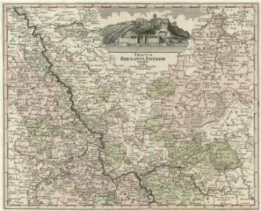
Tractvs Rhenanvs Inferior excusus cura
1 : 810000 Mollova mapová sbírka Weigel, Magdalena Esther Weigel, Johann Christoph - vdova
Deutsch - Französischen Kriegsschauplatzes

Die preussischen Provinzen Westphalen und Rheinprovinz, das Kurfürstenthum Hessen, das Grossherzogthum Hessen und das Herzogthum Nassau, das Fürstenthum Waldeck, die Landgrafschaft Hessen Homburg und die freie Stadt Frankfurt
1 : 540000 Frankfurt nad Mohanem (Německo) Gräf, A. Luther. Th. Geographisches Institut
Operationen der Alliirten und Französischen Armee 1759

Rhein Provinz.
1 : 825000 Flemming, Carl
Geographisch-statistische Post- und Resekarte zu den besuchtesten Rhein- und Main-Gegenden
1 : 831500 Mohan (Německo) Bauerkeller, Georg J.P. Streng
Berghe Ducatus Marck Comitatus et Coloniensis Dioecesis [Karte], in: Gerardi Mercatoris Atlas, sive, Cosmographicae meditationes de fabrica mundi et fabricati figura, S. 346.
1 Karte aus Atlas Mercator, Gerhard Montanus, Petrus
Der Chur Rheinsiche- oder Nieder Rheinische Kreis
1 : 620000 Porýní-Falc (Německo) Güssefeld, Franz L. bey den Homännischen Erben
Der Chur Rheinsiche- oder Nieder Rheinische Kreis
1 : 620000 Porýní-Falc (Německo) Güssefeld, Franz L. bey den Homännischen Erben
Tabula Nova Circuli Electoralis Rheni, ad Usum Serenissimi Burgundae Ducis
1 : 670000 Mollova mapová sbírka Jaillot, Alexis-Hubert Ottens, Josua
Tabula Nova Circuli Electoralis Rheni, ad Usum Serenissimi Burgundae Ducis
1 : 670000 Mollova mapová sbírka Jaillot, Alexis-Hubert Jaillot, Alexis Hubert
Teutschlands Nieder Rheinischer Creiss mit seinen abgetheilten Provintzen
1 : 2600000 Mollova mapová sbírka Weigel, Christoph Weigel, Christoph I.
Geologische Übersichtskarte der Rheinprovinz und der Provinz Westfalen / bearb. von H. von Dechen
1 : 500000 Annotatie: Oorspr. uitg.: 1866 Heinrich von Dechen Berlin : Schropp
Dioecesis Coloniensis
1 : 650000 Kolín nad Rýnem-oblast (Německo)
Berghe Ducatus Marck Comitatus et Coloniensis Dioecesis [Karte], in: Gerardi Mercatoris et I. Hondii Newer Atlas, oder, Grosses Weltbuch, Bd. 1, S. 176.
1 Karte aus Atlas Mercator, Gerhard und Hondius, Jodocus Jansson, Jan
Le Cercle Eslectoral du Rhein subdivisé et touts les Estats qui le composent sur les Memoires le plus Nouveaux
1 : 560000 Mollova mapová sbírka Sanson, Guillaume Cordier, Louis Jaillot, Alexis Hubert

Geologische Übersichtskarte der Rheinprovinz und der Provinz Westfalen / bearb. von H. von Dechen
1 : 500000 Heinrich von Dechen Berlin : Schropp
Charte von den Königlich Preusischen Provinzen Westphalen, Cleve-Berg und Niederrhein dem Kurfürstenthume Hessen, Grosherzogthume Hessen, dem Herzogth. Nassau, Fürstenth. Waldeck und dem Gebiete der freien Stadt Frankfurt
1 : 1080000 Dolní Porýní (Německo) Weiland, Karl Ferdinand im Verlage des Geograph. Instituts
S. R. I. Rhenanus Inferior sive Electorum Rheni
1:500,000 Europe (Air) G.S.G.S. No. 4072, Frankfurt
Sheet NE50-6 from the map series: 1:500,000 Europe (Air) G.S.G.S. No. 4072.
Circulus Electorum Rheni Sive Rhenanus Inferior
1 : 620000 Mollova mapová sbírka Wit, Frederik de Gouwen, Giliam van der Covens, Johannes I
Rhein-Provinz, Nassau.
1 : 980000 Radefeld, Carl Christian Franz, 1788-1874

Circolo Elettorale del Reno
1 : 730000 Mollova mapová sbírka Mariotti, Vincenzo De Rossi, Giovanni Giacomo
Synopsis Circuli Rhenani Inferioris sive Electorum Rheni, exhibens Archi Episcopatum Moguntinum, Coloniensem, Trevirensem et Palatinatum Rheni, Comitatus Beilstein, Newenaer, Isenburg Infer. et Reifferscheid
1 : 800000 ob oculos posita a Matth. Seutter Aug. Vind : Matth. Seutter
Circvlvs Rhenanvs Inferior s. potius Electoralis integer complectens simul Partem mediam Circvli Rhenani Svperioris
1 : 1800000 Mollova mapová sbírka Franz, Johann Michael Homann, Johann Baptista - dědici
Synopsis circuli Rhenani inferioris sive electorum Rheni
1 : 620000 Porýní-Falc (Německo) Lotter, Tobias Conrad Tobias Conrad Lotter
Synopsis circuli Rhenani inferioris sive electorum Rheni
1 : 620000 Porýní-Falc (Německo) Lotter, Tobias Conrad T. C. Lotter
Synopsis circuli Rhenani inferioris sive electorum Rheni
1 : 620000 Porýní-Falc (Německo) Lotter, Tobias Conrad Tobias Conrad Lotter
SYNOPSIS CIRCULI RHENANI INFERIORIS sive ELECTORUM RHENI
1 : 640000 Porýní-Falc (Německo) Seutter, Matthäus a Matth. Seutter