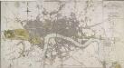
Maps of Kensington and Chelsea

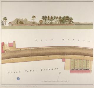
Earls Court Terrace showing Holland House
The land that became Holland Park is shown here. Holland House can be seen in the distance, carefully rendered by Salway with the striking silhouette of this Jacobean mansion immediately recognisable. At the time that this drawing was surveyed the house, (hosted by Lady Holland who had been ostracised at Court), was a centre of literary and political activity. It was frequented by amongst others, the Whigs, George Canning, Byron, Wordsworth, Scott and Dickens. The drawing makes a detailed study of all the features of the roads that would have been under the management of the Turnpike Trust, such as lamp posts, water pumps and stockades for tethering horses. Salway, Joseph
Insurance Plan of London Western District Vol. A: sheet 19
1 : 480 This detailed 1901 plan of London is one of a series of forty-one sheets in an atlas originally produced to aid insurance companies in assessing fire risks. The building footprints, their use (commercial, residential, educational, etc.), the number of floors and the height of the building, as well as construction materials (and thus risk of burning) and special fire hazards (chemicals, kilns, ovens) were documented in order to estimate premiums. Names of individual businesses, property lines, and addresses were also often recorded. Together these maps provide a rich historical shapshot of the commercial activity and urban landscape of towns and cities at the time. The British Library holds a comprehensive collection of fire insurance plans produced by the London-based firm Charles E. Goad Ltd. dating back to 1885. These plans were made for most important towns and cities of the British Isles at the scales of 1:480 (1 inch to 40 feet), as well as many foreign towns at 1:600 (1 inch to 50 feet). Chas E Goad Limited Chas E Goad Limited
Earls Court Terrace
Earls Court Terrace, where a farm stood until the 1860s, is indicated at the bottom of the sheet on the south side of the turnpike road. The White Horse Inn is depicted on the north side of the road in plan and elevation. Before the advent of the railway, inns were the travel centres of London. With their large courtyards, they were able to provide not only refreshment and lodging for travellers, but also stabling and repairs for wagons and coaches and storage facilities for merchants. Salway, Joseph
The Road to Earl's Court
Atoll gate and toll keeper's house are depicted at the junction with the road to Earl's Court. This road was in the care of the Kensington Turnpike Trust, together with another 16 miles of roads in West London. To the left of the toll gate, Lord Holland's Grounds are shown, on which site Holland Park now stands. Salway, Joseph
London VI.98 - OS London Town Plan
1 : 1056 Topographic maps Ordnance Survey Ordnance Survey
London (1915- Numbered sheets) IV.15 (includes: Fulham; Hammersmith; Kensington) - 25 Inch Map
1 : 2500 Topographic maps Ordnance Survey Ordnance Survey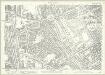
London (Edition of 1894-96) LXXIII (includes: Fulham; Hammersmith; Kensington) - 25 Inch Map
1 : 2500 Topographic maps Ordnance Survey Ordnance Survey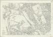
London (First Editions c1850s) XLI (includes: Fulham; Hammersmith; Kensington) - 25 Inch Map
1 : 2500 Topographic maps Ordnance Survey Ordnance Survey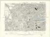
London VI.SE - OS Six-Inch Map
1 : 10560 Topographic maps Ordnance Survey Ordnance Survey
A PLAN of HYDE-PARK with the CITY and LIBERTIES of WESTMINSTER &c. Shewing the several IMPROVEMENTS propos'd
This plan shows renovations in Hyde Park and around Westminster.Two Royal palaces have been planned, in Hyde Park and Green Park. The red lines show an intention to regularize the street plan, replacing the narrow irregular streets with a gridlike formation. Gwynn, John
London SW.
1 : 15840 Stanford, Edward
A PLAN of the ROADS Under the DIRECTION and CARE of this TRUST and divers Roads Adjacent.
1 : 16351 The title of this road map of Kensington and Chelsea appears in a panel above the plan, with the compass star at top right and scale bar at bottom left. The roads within the Kensington and Hyde Park Trust are indicated by a shadowed line; the king's private roads by a double line; the common roads by a double dotted line; and the footpaths by a single dotted line. Turnpikes and junctions are numbered for reference with distances given in a table down the left side of the plate. Roberts, R.
MAP OF THE WESTERN SIDE OF LONDON, DISTINGUISHING THE ESTATE OF HER MAJESTY'S COMMISSIONERS FOR THE EXHIBITION OF 1851.
1 : 21120 Map of Kensington with title along the top and scale bar below the plan. The site of the Great Exhibiton of 1851 in Hyde Park is highlighted in green. Day & Son
Insurance Plan of London West & West North West Vols. A & B: Key Plan
1 : 10560 This "key plan" indicates coverage of the Goad 1891 series of fire insurance maps of London that were originally produced to aid insurance companies in assessing fire risks. The building footprints, their use (commercial, residential, educational, etc.), the number of floors and the height of the building, as well as construction materials (and thus risk of burning) and special fire hazards (chemicals, kilns, ovens) were documented in order to estimate premiums. Names of individual businesses, property lines, and addresses were also often recorded. Together these maps provide a rich historical shapshot of the commercial activity and urban landscape of towns and cities at the time. The British Library holds a comprehensive collection of fire insurance plans produced by the London-based firm Charles E. Goad Ltd. dating back to 1885. These plans were made for most important towns and cities of the British Isles at the scales of 1:480 (1 inch to 40 feet), as well as many foreign towns at 1:600 (1 inch to 50 feet). Chas E Goad Limited Chas E Goad Limited
Insurance Plan of London West North-West District Vol. B: Key Plan
1 : 3600 This "key plan" indicates coverage of the Goad 1902 series of fire insurance maps of London that were originally produced to aid insurance companies in assessing fire risks. The building footprints, their use (commercial, residential, educational, etc.), the number of floors and the height of the building, as well as construction materials (and thus risk of burning) and special fire hazards (chemicals, kilns, ovens) were documented in order to estimate premiums. Names of individual businesses, property lines, and addresses were also often recorded. Together these maps provide a rich historical shapshot of the commercial activity and urban landscape of towns and cities at the time. The British Library holds a comprehensive collection of fire insurance plans produced by the London-based firm Charles E. Goad Ltd. dating back to 1885. These plans were made for most important towns and cities of the British Isles at the scales of 1:480 (1 inch to 40 feet), as well as many foreign towns at 1:600 (1 inch to 50 feet). Chas E Goad Limited Chas E Goad Limited
An exact survey of the city's of London Westminster , XI
1 Blatt : 53 x 71 cm John Rocque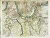
An exact survey of the city's of London Westminster , X
1 Blatt : 53 x 71 cm John Rocque
London Sheet J - OS Six-Inch Map
1 : 10560 Topographic maps Ordnance Survey Ordnance Survey
London Sheet J - OS Six-Inch Map
1 : 10560 Topographic maps Ordnance Survey Ordnance Survey
Middlesex XVI - OS Six-Inch Map
1 : 10560 Topographic maps Ordnance Survey Ordnance Survey
Surrey II - OS Six-Inch Map
1 : 10560 Topographic maps Ordnance Survey Ordnance Survey
Insurance Plan of London Western District Vol. A: Key Plan
1 : 21120 This "key plan" indicates coverage of the Goad 1901 series of fire insurance maps of London that were originally produced to aid insurance companies in assessing fire risks. The building footprints, their use (commercial, residential, educational, etc.), the number of floors and the height of the building, as well as construction materials (and thus risk of burning) and special fire hazards (chemicals, kilns, ovens) were documented in order to estimate premiums. Names of individual businesses, property lines, and addresses were also often recorded. Together these maps provide a rich historical shapshot of the commercial activity and urban landscape of towns and cities at the time. The British Library holds a comprehensive collection of fire insurance plans produced by the London-based firm Charles E. Goad Ltd. dating back to 1885. These plans were made for most important towns and cities of the British Isles at the scales of 1:480 (1 inch to 40 feet), as well as many foreign towns at 1:600 (1 inch to 50 feet). Chas E Goad Limited Chas E Goad Limited
Map shewing the situation of all premises licensed for the sale of intoxicating liquors in the County of London
London County Council
CARY'S New and Accurate Plan of LONDON, WESTMINSTER, the Borough of SOUTHWARK and parts adjacent
John Cary was possibly the most productive English map maker and publisher of the18th Century. His works were reissued many times, but unlike many of his contemporaries he aimed to update each edition by showing new developments. This is the third edition of a map first published in 1787. The developments in Somers Town are shown; the Lambeth and London roads are named. The numerous parks and gardens across the city are coloured green. The map is divided into squares, numbered for reference. Cary, John
TQ27 - OS 1:25,000 Provisional Series Map
1 : 25000 Topographic maps Ordnance Survey Ordnance Survey
CARY'S New and Accurate Plan of LONDON AND WESTMINSTER, the Borough of SOUTHWARK and parts adjacent 210
This title of this folding map of London appears along the top. Open spaces are depicted in colour with a reference table in a panel below the plan. This is the twelfth edition of the map first issued by Cary in 1787, updated to include several new works of the Regency period. An added sheet extends eastward to include the Isle of Dogs and the East and West India Docks. Cary, John
CARY'S New and Accurate Plan of LONDON AND WESTMINSTER, the Borough of SOUTHWARK and parts adjacent 221
The title of this folding map of London runs along the top, with a list of public buildings at top left, facing a list of churches at top right. Open spaces and the city boundaries are drawn in colour, withal reference table in the panel below the plan. John Cary, who first published this map in 1787, added a sheet to this later edition to include the Lea River, the Isle of Dogs and the new docks. The map also shows the Asylum for the Blind in St. George's Fields and the Penitentiary at Millbank. Cary, John
Central London : Recto
1 : 15840 G.W. Bacon & Co G.W. Bacon & Co.
Central London : Verso
1 : 15840 G.W. Bacon & Co G.W. Bacon & Co.