Maps of Northumberland
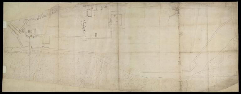
Bamburgh Castle f.2
This is a drawing of Bamburgh Castle, Northumberland,thought to date from the period 1539-47. The states of defences were a matter of great concern at this time as Henry VIII feared an invasion from the combined forces of France and Spain. In 1538 Francis I of France, and Charles V Holy Roman Emperor and King of Spain signed a peace treaty. This union gave rise to the possibility that France and Spain may combine forces to invade England. France was England’s historical enemy and Henry VIII’s divorce of Catherine of Aragon, Charles V’s aunt, had offended the militantly catholic King of Spain.
Northumberland (Old Series) XVII.1 (inset XVII.5) (includes: Bamburgh Castle; Bamburgh) - 25 Inch Map
1 : 2500 Topographic maps Ordnance Survey Ordnance Survey
Northumberland nXIII.SW - OS Six-Inch Map
1 : 10560 Topographic maps Ordnance Survey Ordnance Survey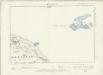
Northumberland XVII.NW - OS Six-Inch Map
1 : 10560 Topographic maps Ordnance Survey Ordnance Survey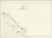
Northumberland XVII - OS Six-Inch Map
1 : 10560 Topographic maps Ordnance Survey Ordnance Survey
NU13 - OS 1:25,000 Provisional Series Map
1 : 25000 Topographic maps Ordnance Survey Ordnance Survey
INSVLA SACRA; | Vulgo | HOLY ILAND [!]; | et | FARNE.
[Amsterdam : Joan Blaeu]
Insula Sacra; Vulgo Holy Iland; et Farne. [Karte], in: Theatrum orbis terrarum, sive, Atlas novus, Bd. 4, S. 530.
1 Karte aus Atlas Blaeu, Joan Blaeu, Willem Janszoon
Insula Sacra; Vulgo Holy Island; et Farne. [Karte], in: Le théâtre du monde, ou, Nouvel atlas contenant les chartes et descriptions de tous les païs de la terre, Bd. 4, S. 446.
1 Karte aus Atlas Blaeu, Willem Janszoon und Blaeu, Joan Blaeu, Willem Janszoon
Insvla sacra; vulgo Holy Iland; et Farne
1 Karte : Kupferdruck ; 37 x 49 cm Blaeu Joan Blaeu
Insula Sacra; Vulgo Holy Iland; et Farne. [Karte], in: Theatrum orbis terrarum, sive, Atlas novus, Bd. 4, S. 530.
1 Karte aus Atlas Blaeu, Joan Blaeu, Willem Janszoon
Holy Iland ; Garnsey ; Farne ; Iarsey
[Amstelodami] : [apud Joannem Janssonium]
Holy Island (Hills) - OS One-Inch Revised New Series
1 : 63360 Topographic maps Ordnance Survey Ordnance Survey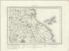
Holy Island (Outline) - OS One-Inch Revised New Series
1 : 63360 Topographic maps Ordnance Survey Ordnance Survey
Alnwick - OS One-Inch Map
1 : 63360 Topographic maps Ordnance Survey Ordnance Survey
Northumberland, North, Sheet 1 - Bartholomew's "Half Inch to the Mile Maps" of England & Wales
1 : 126720 Topographic maps Bartholomew, John George John Bartholomew & Co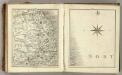
Sheets 68-69. (Cary's England, Wales, and Scotland).
1 : 360000 Cary, John, ca. 1754-1835
A new improved map of Northumberland
1 Karte : Kupferdruck ; 67 x 50 cm Kitchin; Hinton sold by J. Hinton at the Kings Arms in St. Pauls Church Yard
Comitatvs Northvmbria; vernacula Northvmberland
1 Karte : Kupferdruck ; 39 x 48 cm Blaeu Joan Blaeu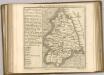

Holy-Island, Fairn Islands with the many Rocks and Hazards that lye Scatter'd in that Sea, and the Coast from Sunderland point in England to St Abbs-head in Scotland, survey'd and navigated by J[oh]n
Adair, John, ca. 1650-1722
COMITATVS | NORTHVMBRIA; | Vernacule | NORTHUMBERLAND.
Ioh. Blaeu Exc.
Comitatus Northumbria vernacule Northumberland
1 : 300000 Amstelodami : apud Joannem Janssonium
Beschrijvinge van een deel vann Schottlandt van Bambourg tot Aberdein : daer Edenburg de princepaele Coepstat in is, So hem tlant daer 'bthoont, beneffens 2 eÿlende / door Lucas Ianss Wagenaer ; Ioann
Waghenaer, Lucas Janszoon, 1534 or 5-1606
Comitatus Northumbria; Vernacule Northumberland. [Karte], in: Le théâtre du monde, ou, Nouvel atlas contenant les chartes et descriptions de tous les païs de la terre, Bd. 4, S. 431.
1 Karte aus Atlas Blaeu, Willem Janszoon und Blaeu, Joan Blaeu, Willem Janszoon
England and Wales 1:253,440
Ordnance Survey
NORTHIMBRIAE COMITATUS
This map of Northumbria is from the 1583 edition of the Saxton atlas of England and Wales.This atlas was first published as a whole in 1579. It consists of 35 coloured maps depicting the counties of England and Wales. The atlas is of great significance to British cartography as it set a standard of cartographic representation in Britain and the maps remained the basis for English county mapping, with few exceptions, until after 1750. During the reign of Elizabeth I map use became more common, with many government matters referring to increasingly accurate maps with consistent scales and symbols, made possible by advances in surveying techniques. Illustrating the increasing used of maps in government matters, Lord Burghley, Elizabeth I’s Secretary of State, who had been determined to have England and Wales mapped in detail from the 1550s, selected the cartographer Christopher Saxton to produce a detailed and consistent survey of the country. The financier of the project was Thomas Seckford Master of Requests at the Court of Elizabeth I, whose arms appear, along with the royal crest, on each map. Saxton, Christopher Ryther, Augustine
Comitatus Northumbria Vernacule Northumberland. [Karte], in: Theatrum orbis terrarum, sive, Atlas novus, Bd. 4, S. 505.
1 Karte aus Atlas Blaeu, Joan Blaeu, Willem Janszoon
Sheet 1 The Border, uit: Maps of England & Wales : scale 4 miles to 1 inch / Ordnance Survey
1 : 253440 titelvariant: Maps of England and Wales; Annotatie: Titel op cassette; Met bladoverzicht op de achterzijde van de cassette; Annotatie geografische gegevens: Hoogtelijneninterval 200 ft Ordnance Survey, United Kingdom Southampton : Ordnance Survey Office