Maps of Angus

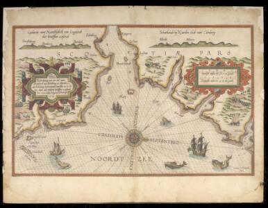
Beschrijvinge van een deel vann Schottlandt van Bambourg tot Aberdein : daer Edenburg de princepaele Coepstat in is, So hem tlant daer 'bthoont, beneffens 2 eÿlende / door Lucas Ianss Wagenaer ; Ioann
Waghenaer, Lucas Janszoon, 1534 or 5-1606
Nordsee
1 : 150000 Severní moře Reichs-Marine-Amt
A chart of part of the South of Scotland, from Berwick upon Tweed to Skateraw Harbour in the County of Kincardine...
Ainslie, John, 1745-1828
A chart of part of the South of Scotland, from Berwick upon Tweed to Skateraw Harbour in the County of Kincardine...
Ainslie, John, 1745-1828
A chart of part of the South of Scotland, from Berwick upon Tweed to Skateraw Harbour in the County of Kincardine...
Ainslie, John, 1745-1828
A chart of part of the South of Scotland, from Berwick upon Tweed to Skateraw Harbour in the County of Kincardine...
Ainslie, John, 1745-1828
The Sea coast from Fiffnesse to Montros / was Survey'd by Mr. Mar, an injenious Marriner [sic] of Dundee. Sea coast from Fife Ness to Montrose.
Marr, John, fl. 1660-1720 Collins, Greenvile, fl. 1669-1698
Nieuwe en seer perfecte paskaart van Schotlandt ... van Berwyk tot Bokannais = A new and pertinent map of the eastern sea-coasts of Scotland ... from the cost of Berwik till Bokaness / by John Marr of
Marr, John, fl. 1660-1720
East Lothian, Sheet 9 - Bartholomew's "Half Inch to the Mile Maps" of Scotland
1 : 126720 Topographic maps John Bartholomew & Son, Ltd John Bartholomew & Son, Ltd
Berwick & Haddington, Sheet 9 - Bartholomew's "Half Inch to the Mile Maps" of Scotland
1 : 126720 Topographic maps Bartholomew, John George John Bartholomew & Co
Deeside, Sheet 17 - Bartholomew's "Half Inch to the Mile Maps" of Scotland
1 : 126720 Topographic maps John Bartholomew & Son, Ltd John Bartholomew & Son, Ltd
Aberdeen & Deeside, Sheet 17 - Bartholomew's "Half Inch to the Mile Maps" of Scotland
1 : 126720 Topographic maps Bartholomew, John George John Bartholomew & Co
Montrose - Bartholomew's 'Survey Atlas of Scotland'
1 : 126720 Topographic maps John Bartholomew & Son, Ltd John Bartholomew & Son, Ltd
Dunbar, St Andrews, Etc. - Bartholomew's 'Survey Atlas of Scotland'
1 : 126720 Topographic maps John Bartholomew & Son, Ltd John Bartholomew & Son, Ltd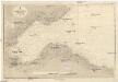
Nordsee
1 : 75000 Severní moře Reichs-Marine-Amt
THE MERCE | or Shirrefdome of | BERWICK. [=] MERCIA | Vulgo | VICECOMITATVS BERVICENSIS
Auct Timothei Pont [Amsterdam : Joan Blaeu]
Angusia provincia scotiæ sive the shire of Angus
1 Karte : Kupferdruck ; 42 x 50 cm Valck; Schenk sumptibus Gerardi Valk et Petri Schenk
Stonehaven - OS One-Inch Map
1 : 63360 Topographic maps Ordnance Survey Ordnance Survey
Dunbar - OS One-Inch Map
1 : 63360 Topographic maps Ordnance Survey Ordnance Survey
Forfar - OS One-Inch Map
1 : 63360 Topographic maps Ordnance Survey Ordnance Survey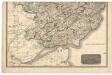
Southern Part of Angus Shire.
Thomson, John, 1777- ca. 1840 Johnson, William, fl. 1806-1840
Northern Part of Angus Shire.
Thomson, John, 1777- ca. 1840 Johnson, William, fl. 1806-1840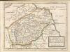
The Shire of Berwick alias the Mers or March and Lauderdale / by H. Moll.
Moll, Herman, d. 1732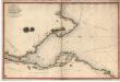
Survey of the Frith [sic] of Forth, by George Thomas... in 1815
Thomas, George, fl. 1809-1846 Great Britain. Hydrographic Office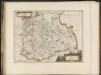
Mercia, vulgo vicecomitatus, Bervicensis / auct. Timothei Pont. Merce or Shirrefdome of Berwick.
Pont, Timothy, 1560?-1614? Blaeu, Joan 1596-1673
Mercia vulgo vicecomitatvs Bervicensis
1 Karte : Kupferdruck ; 36 x 48 cm Pont; Blaeu Joan Blaeu
Angusia Provincia Scotiae sive The Shire of Angus. Shire of Angus.
Edward, Robert, ca. 1616-1696
St Andrews and Kirkcaldy - OS One-Inch Map
1 : 63360 Topographic maps Ordnance Survey Ordnance Survey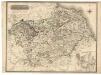
Berwick-Shire.
Thomson, John, 1777- ca. 1840 Johnson, William, fl. 1806-1840
Map of the County of Berwick.
Armstrong, Andrew, 1700-1794 Armstrong, Mostyn, fl. 1769-1791
Map of the County of Berwick.
Armstrong, Andrew, 1700-1794 Armstrong, Mostyn, fl. 1769-1791
Berwickshire.
Blackadder, John, fl. 1793-1830
Map of the County of Berwick.
Armstrong, Andrew, 1700-1794 Armstrong, Mostyn, fl. 1769-1791
The County of Berwick.
Greenwood, Christopher, 1786-1855 Fowler, William, fl. 1818-1863 Sharp, T.
The County of Berwick.
Greenwood, Christopher, 1786-1855 Fowler, William, fl. 1818-1863 Sharp, T.