Maps of Northumberland

A new improved map of Northumberland
1 Karte : Kupferdruck ; 67 x 50 cm Kitchin; Hinton sold by J. Hinton at the Kings Arms in St. Pauls Church Yard
Comitatvs Northvmbria; vernacula Northvmberland
1 Karte : Kupferdruck ; 39 x 48 cm Blaeu Joan Blaeu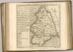

COMITATVS | NORTHVMBRIA; | Vernacule | NORTHUMBERLAND.
Ioh. Blaeu Exc.
Comitatus Northumbria vernacule Northumberland
1 : 300000 Amstelodami : apud Joannem Janssonium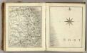
Sheets 68-69. (Cary's England, Wales, and Scotland).
1 : 360000 Cary, John, ca. 1754-1835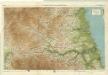
Northumberland, South, Sheet 2 - Bartholomew's "Half Inch to the Mile Maps" of England & Wales
1 : 126720 Topographic maps Bartholomew, John George John Bartholomew & Co
Northumberland, North, Sheet 1 - Bartholomew's "Half Inch to the Mile Maps" of England & Wales
1 : 126720 Topographic maps Bartholomew, John George John Bartholomew & Co
Cheviots - Bartholomew's 'Survey Atlas of Scotland'
1 : 126720 Topographic maps John Bartholomew & Son, Ltd John Bartholomew & Son, Ltd
Alnwick - OS One-Inch Map
1 : 63360 Topographic maps Ordnance Survey Ordnance Survey
Newcastle Upon Tyne - OS One-Inch Map
1 : 63360 Topographic maps Ordnance Survey Ordnance Survey
Hexham - OS One-Inch Map
1 : 63360 Topographic maps Ordnance Survey Ordnance Survey
Jedburgh - OS One-Inch Map
1 : 63360 Topographic maps Ordnance Survey Ordnance Survey
Kelso & The Cheviot (81) - OS One-Inch map
1 : 63360 Topographic maps Ordnance Survey Ordnance Survey
Kelso & The Cheviot (81) - OS One-Inch map
1 : 63360 Topographic maps Ordnance Survey Ordnance Survey
The Cheviot Hills (86) - OS One-Inch map
1 : 63360 Topographic maps Ordnance Survey Ordnance Survey
The Cheviot Hills (86) - OS One-Inch map
1 : 63360 Topographic maps Ordnance Survey Ordnance Survey
Morebattle - OS One-Inch map
1 : 63360 Topographic maps Ordnance Survey Ordnance Survey
Morebattle - OS One-Inch map
1 : 63360 Topographic maps Ordnance Survey Ordnance Survey
Morebattle - OS One-Inch map
1 : 63360 Topographic maps Ordnance Survey Ordnance Survey
Berwick Upon Tweed - OS One-Inch map
1 : 63360 Topographic maps Ordnance Survey Ordnance Survey
Berwick Upon Tweed - OS One-Inch map
1 : 63360 Topographic maps Ordnance Survey Ordnance Survey
Berwick Upon Tweed - OS One-Inch map
1 : 63360 Topographic maps Ordnance Survey Ordnance Survey
Map embracing extensive portions of the Counties of Roxburgh, Berwick, Selkirk & Midlothian and Part of Northumberland. Minutely & accurately surveyed... by Crawford and Brooke
Crawford, William, 1793-ca.1845 Brooke, William, fl. 1835-47.
Map embracing extensive portions of the Counties of Roxburgh, Berwick, Selkirk & Midlothian and Part of Northumberland. Minutely & accurately surveyed... by Crawford and Brooke
Crawford, William, 1793-ca.1845 Brooke, William, fl. 1835-47.
Map embracing extensive portions of the Counties of Roxburgh, Berwick, Selkirk & Midlothian and Part of Northumberland. Minutely & accurately surveyed... by Crawford and Brooke
Crawford, William, 1793-ca.1845 Brooke, William, fl. 1835-47.
Map embracing extensive portions of the Counties of Roxburgh, Berwick, Selkirk & Midlothian and Part of Northumberland. Minutely & accurately surveyed... by Crawford and Brooke
Crawford, William, 1793-ca.1845 Brooke, William, fl. 1835-47.
Map embracing extensive portions of the Counties of Roxburgh, Berwick, Selkirk & Midlothian and Part of Northumberland. Minutely & accurately surveyed... by Crawford and Brooke
Crawford, William, 1793-ca.1845 Brooke, William, fl. 1835-47.
Map embracing extensive portions of the Counties of Roxburgh, Berwick, Selkirk & Midlothian and Part of Northumberland. Minutely & accurately surveyed... by Crawford and Brooke
Crawford, William, 1793-ca.1845 Brooke, William, fl. 1835-47.
Map embracing extensive portions of the Counties of Roxburgh, Berwick, Selkirk & Midlothian and Part of Northumberland. Minutely & accurately surveyed... by Crawford and Brooke
Crawford, William, 1793-ca.1845 Brooke, William, fl. 1835-47.
Map embracing extensive portions of the Counties of Roxburgh, Berwick, Selkirk & Midlothian and Part of Northumberland. Minutely & accurately surveyed... by Crawford and Brooke
Crawford, William, 1793-ca.1845 Brooke, William, fl. 1835-47.


