Maps of Essex
Mouths of the Thames and Medway from Ipswich to Sandwich and Maldon and Rochester to the Sea
This is a map showing the mouths of the Thames and the Medway from Ipswich to Sandwich and Maldon and Rochester to the sea. It dates from around 1544 and is annotated Rycherd Cavendishe made this carde’. Richard Cavendish was a master gunner who had supervised new defence works at Berwick and Wark in 1522-3. The map seems to have been made with the purposes of defence and navigation in mind. Coastal forts and navigational channels are shown. The shoreline is exaggerated in order to illustrate clearly how an enemy might move ashore and how they might be stopped. In this case the enemy was England’s ancient adversary France, with whom hostilities had resumed in 1542. This map of the vulnerable south east coast, was made against this historical background. The fear of a French invasion was very real. In 1514 the French had invaded Brighton, and in 1545 French ships entered the Solent and landed on the Isle of Wight. The lines which cover the sea areas of the map are called rhumb lines. These are lines of constant bearing that radiate from compass roses and allow the sailor to plot a course from harbour to harbour using dividers and straight edge. Vignettes of several towns are included on this map, Sandwich, Rochester and Canterbury are shown. The view of Essex is possibly derived from a survey Cavendish made in 1520. Other settlements are formalized showing rows of red roofed houses with a church in the centre. A scale bar annotated by 3’ is included, however, as this occupies a green painted area it is likely that this was added later. Cavendish, Richard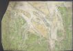
Chart of the mouth of the River Thames, c1540
This map, showing parts of Kent and Sussex, comes from a 16th-century portfolio of coastal charts and drawings It incorporates miniature copies of town plans that are now lost including what are probably the earliest plans of Canterbury, Rochester and Sandwich The mapmaker was Sir Richard Cavendish With its emphasis on sandbanks and beaches, the map was evidently intended for navigation and defence purposes The decorative quality of the map suggests it was meant for the eyes of the king, Henry VIII North is to the left of the map and East to the top, making the map appear on its side to modern eyes Cavendish, Sir Richard
To the Right Honourable the Master, Wardens, & Elder Bretham of the Trinity House, this chart of the entrances to The River Thames is ... dedicated
1 : 170000 Heather, W. (William) Heather, W. (William)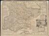
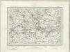
An accurate map of the county of Essex, divided into its hundreds
1 : 180000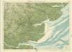
Essex, Sheet 26 - Bartholomew's "Half Inch to the Mile Maps" of England & Wales
1 : 126720 Topographic maps Bartholomew, John George John Bartholomew & Co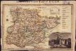
Langley's new map of Essex
1 : 488000
Southend-On-Sea - OS One-Inch Map
1 : 63360 Topographic maps Ordnance Survey Ordnance Survey
Ipswitch - OS One-Inch Map
1 : 63360 Topographic maps Ordnance Survey Ordnance Survey
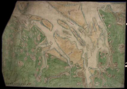
Ipswich
1 : 31680 This drawing of parts of Essex and Suffolk is made up from four conjoined sheets mounted on stiff card. Verron's reputation as a surveyor suffered over the course of the survey. A letter from Survey Superintendent, William Mudge, dated 11 October 1820, reads: "Mr Stanley is going with me ...to Woodbridge to examine what is necessary to be done with Mr Verron's Plans...I apprehend they are much worse than... I expected." Verron
A Coloured Chart of the Coast of Essex and Suffolk, from the Naze to Bawdsey
This is a chart showing Essex and Suffolk from the Naze to Bawdsey showing the course of the Stour, Orwell, and Deben. It is thought to date from between 1539 and 1544. It shows miniaturized views of towns such as Ipswich and Harwich against a generalized green landscape of fields and occasional trees. The coast line and waterways are the main preoccupation of the cartographer as he has carefully recorded areas of sand in pink with stippled markings, and at certain points the depths of the water at low tide in area is noted. The cartographer is Richard Cavendish, whose family home in Suffolk is indicated. Richard Cavendish was a master gunner who had supervised new defence works at Berwick and Wark in 1522-3. It is thought that this map was based on a survey that Cavendish was paid to undertake in 1523. The date exact date of the map is uncertain. It could date from around 1538-9, a period characterised by the threat of invasion after a peace treaty was signed by Francis I of France and Charles V, Holy Roman Emperor and King of Spain in 1538. England and France were ancient enemies and the catholic Charles V, nephew of Catherine of Aragon, was angered by Henry VIII’s decision to divorce her. However, the presence of a scale bar in the bottom right corner suggests a date of post 1540. In 1543 war with France resumed and England was threatened by invasion once again. This map may be related to a large map which is referred to in Henry VIII’s inventory of 1547-80 the description of parte of Suffolke, Essexe and London painted upon clothe’ Cavendish, Richard
Colchester (Outline) - OS One-Inch Revised New Series
1 : 63360 Topographic maps Ordnance Survey Ordnance Survey
Colchester (Hills) - OS One-Inch Revised New Series
1 : 63360 Topographic maps Ordnance Survey Ordnance Survey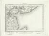
Brightlingsea (Outline) - OS One-Inch Revised New Series
1 : 63360 Topographic maps Ordnance Survey Ordnance Survey
Brightlingsea (Hills) - OS One-Inch Revised New Series
1 : 63360 Topographic maps Ordnance Survey Ordnance Survey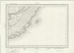
Foulness (Outline) - OS One-Inch Revised New Series
1 : 63360 Topographic maps Ordnance Survey Ordnance Survey
Faversham (Hills) - OS One-Inch Revised New Series
1 : 63360 Topographic maps Ordnance Survey Ordnance Survey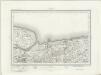
Faversham (Outline) - OS One-Inch Revised New Series
1 : 63360 Topographic maps Ordnance Survey Ordnance Survey
Colchester - OS One-Inch Map
1 : 63360 Topographic maps Ordnance Survey Ordnance Survey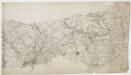
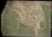
Witham
Colchester is the largest settlement featured on this drawing. The draughtsman has recorded the layout of the streets in red ink. On nearby Lexden Heath, an 'Ancient Intrenchment' is depicted. These lines of entrenchment date back to the Roman occupation. The drawing extends to cover Mersey Island and the River Colne. The salt marshes are distinguished by irregular patterning and the individual channels of the Colne are named. A military battery is marked at the mouth of the river, reflecting the military focus of these drawings. A blue line indicates the level of the low water mark.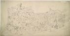
Halstead
1 : 31680 Oval gaps have been left in the forested areas of this unfinished plan to allow place names to be inserted later. The road network is complete, indicating that communication routes were the first aspect of the area to be recorded, a reflection of the military imperative of the Survey. Yeakell, Thomas
A topographical-map, of the county of Kent, [5]
1 Blatt : 54 x 70 cm A. Dury, W. Herbert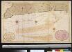
Nieuwe afteekening van het Margat en Noord Voorlandt met alle desselfs gelegenthede
England Gerard van Keulen
A Map of the Isle of Sheppey
This map of the Isle of Sheppey dates from 1574 and is thought to be the work of the cartographer Robert Lythe.Lythewas a cartographer of note as he created the first accurate map of Ireland while under the employ of the Crown and is therefore comparable to Christopher Saxton in his importance in the context of the history of cartography. This map was created for the purposes of defence and also to solve the problem of drainage in the area. The emphasis on streams and waterways suggests a link with the repeated attempts to avoid the silting up of Sandwich Haven by increasing the amount of water it could hold. The works were to be financed by a local levy, hence perhaps the prominence of names which may be a guide to apportionment. Anglo-Spanish relations had been in steady decline since the accession of the protestant Elizabeth I in 1558. In 1574 there was a fear that the Spanish would launch an attack from the Netherlands on ships at Chatham. In the idea of transferring the main fleet to Queenborough was suggested as a precaution. Under the command of Sir William Winter, Surveyor of the Navy and Sir William Pelham, Lieutenant General of Ordnance, and Lythe a survey of Sheppey was carried out. Sheerness and the Isle of Grain were rejected in favour of a new port at Swaleness opposite Queenbrough which would prevent a raid from the rear by way of the Swale. Swaleness was a marsh and in order to build fortifications drainage and embanking or the area was necessary. This was authorised by the Privy Council in September 1574. Earthworks were created but the fortifications were not built and in the event the Spanish did not invade until 1588. Lythe, Robert
Braintree (Hills) - OS One-Inch Revised New Series
1 : 63360 Topographic maps Ordnance Survey Ordnance Survey
Braintree (Outline) - OS One-Inch Revised New Series
1 : 63360 Topographic maps Ordnance Survey Ordnance Survey
Carte réduite de la rade des dunes
1 Karte : Kupferdruck ; 56 x 40 cm Bellin s.n.
Ramsgate (Hills) - OS One-Inch Revised New Series
1 : 63360 Topographic maps Ordnance Survey Ordnance Survey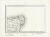
Ramsgate (Outline) - OS One-Inch Revised New Series
1 : 63360 Topographic maps Ordnance Survey Ordnance Survey
Chelmsford (Hills) - OS One-Inch Revised New Series
1 : 63360 Topographic maps Ordnance Survey Ordnance Survey