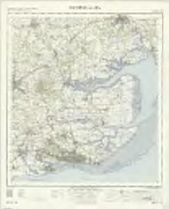
Maps of Southend-on-Sea

Southend-On-Sea - OS One-Inch Map
1 : 63360 Topographic maps Ordnance Survey Ordnance Survey
Chelmsford (Hills) - OS One-Inch Revised New Series
1 : 63360 Topographic maps Ordnance Survey Ordnance Survey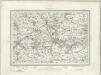
Chelmsford (Outline) - OS One-Inch Revised New Series
1 : 63360 Topographic maps Ordnance Survey Ordnance Survey
Shoeburyness (Hills) - OS One-Inch Revised New Series
1 : 63360 Topographic maps Ordnance Survey Ordnance Survey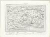
Shoeburyness (Outline) - OS One-Inch Revised New Series
1 : 63360 Topographic maps Ordnance Survey Ordnance Survey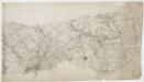
Witham
Colchester is the largest settlement featured on this drawing. The draughtsman has recorded the layout of the streets in red ink. On nearby Lexden Heath, an 'Ancient Intrenchment' is depicted. These lines of entrenchment date back to the Roman occupation. The drawing extends to cover Mersey Island and the River Colne. The salt marshes are distinguished by irregular patterning and the individual channels of the Colne are named. A military battery is marked at the mouth of the river, reflecting the military focus of these drawings. A blue line indicates the level of the low water mark.
A topographical-map, of the county of Kent, 3
1 Blatt : 54 x 69 cm A. Dury, W. Herbert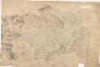
Maldon
This drawing covers the area surrounding the Blackwater River. Pencil lines radiate from trigonometrical stations: notable fixed locations from which angular measurements were taken. Rays emanating from Iltney near the centre of the map, on the south bank of the river, have been used to plot the relative position of the Chigborough Road on the opposite bank. The marshes around Tollesbury Fleet are indicated by irregular intersecting lines.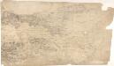
Althorne
This drawing covers the course of the River Crouch. Field boundaries on the marshlands of New England Island and Potten Island are drawn with a waved line to distinguish them from those on dry land. The marshes were used for arable farming, especially wheat. On the right-hand side of the plan is the mouth of the Whittaker Channel. Signal houses are noted on either side, and the salt marshes are indicated by irregular lines. Budgen, Charles
A topographical-map, of the county of Kent, 4
1 Blatt : 54 x 70 cm A. Dury, W. Herbert
Braintree (Hills) - OS One-Inch Revised New Series
1 : 63360 Topographic maps Ordnance Survey Ordnance Survey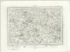
Braintree (Outline) - OS One-Inch Revised New Series
1 : 63360 Topographic maps Ordnance Survey Ordnance Survey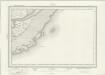
Foulness (Outline) - OS One-Inch Revised New Series
1 : 63360 Topographic maps Ordnance Survey Ordnance Survey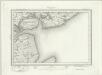
Brightlingsea (Outline) - OS One-Inch Revised New Series
1 : 63360 Topographic maps Ordnance Survey Ordnance Survey
Brightlingsea (Hills) - OS One-Inch Revised New Series
1 : 63360 Topographic maps Ordnance Survey Ordnance Survey
Brentwood, Essex
This drawing covers the settlements and surrounding country of part of Essex. Brentwood is the largest of these settlements. The layout of the town is indicated by red blocks. The straight line of the road leading to the town reveals its Roman origin, although the draughtsman, unusually, does not label it as such. The main communication routes are coloured yellow, conforming to military cartographic standards. The meanderings of the River Crouch are painstakingly plotted, with the surrounding open land represented by dots. Budgen, Charles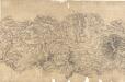
Chelmsford 8
Lines in pencil and red ink radiate from trigonometrical stations within the drawing and from the margins. Chelmsford is the largest settlement in the area. A straight, unmarked Roman road leads out from the city. The fact that the road is coloured yellow suggests it was still considered a major communication route. Three mills are marked on the River Chelmer. Marshland along the riverbanks is indicated by rows of dashes, differentiating it from the surrounding cultivated land. A lake and individual trees in the grounds of Moulsham Hall are recorded, towards the bottom of the landmass, a reminder of the meticulous nature of the Survey.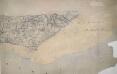
Prittlewell
This drawing shows the flat marshlands of Foulness Island . The draughtsman has indicated the sands by stippling and detailed the channels leading from the North Sea. The most striking feature is the sea wall, shown as a grey angular line extending along the coast and the channels. A signal staff is marked at Wakering Stairs, while the word 'Flag', indicating a trigonometric station, is marked at Aspins Head.
TM02 - OS 1:25,000 Provisional Series Map
1 : 25000 Topographic maps Ordnance Survey Ordnance Survey
TM01 - OS 1:25,000 Provisional Series Map
1 : 25000 Topographic maps Ordnance Survey Ordnance Survey
TL92 - OS 1:25,000 Provisional Series Map
1 : 25000 Topographic maps Ordnance Survey Ordnance Survey
TM00 - OS 1:25,000 Provisional Series Map
1 : 25000 Topographic maps Ordnance Survey Ordnance Survey
TL91 - OS 1:25,000 Provisional Series Map
1 : 25000 Topographic maps Ordnance Survey Ordnance Survey
TL82 - OS 1:25,000 Provisional Series Map
1 : 25000 Topographic maps Ordnance Survey Ordnance Survey
TL90 - OS 1:25,000 Provisional Series Map
1 : 25000 Topographic maps Ordnance Survey Ordnance Survey
TR09 & Parts of TR08 - OS 1:25,000 Provisional Series Map
1 : 25000 Topographic maps Ordnance Survey Ordnance Survey
TL81 - OS 1:25,000 Provisional Series Map
1 : 25000 Topographic maps Ordnance Survey Ordnance Survey
TQ99 - OS 1:25,000 Provisional Series Map
1 : 25000 Topographic maps Ordnance Survey Ordnance Survey
TL72 - OS 1:25,000 Provisional Series Map
1 : 25000 Topographic maps Ordnance Survey Ordnance Survey