Maps of Essex
Chart of the mouth of the River Thames, c1540
This map, showing parts of Kent and Sussex, comes from a 16th-century portfolio of coastal charts and drawings It incorporates miniature copies of town plans that are now lost including what are probably the earliest plans of Canterbury, Rochester and Sandwich The mapmaker was Sir Richard Cavendish With its emphasis on sandbanks and beaches, the map was evidently intended for navigation and defence purposes The decorative quality of the map suggests it was meant for the eyes of the king, Henry VIII North is to the left of the map and East to the top, making the map appear on its side to modern eyes Cavendish, Sir Richard
To the Right Honourable the Master, Wardens, & Elder Bretham of the Trinity House, this chart of the entrances to The River Thames is ... dedicated
1 : 170000 Heather, W. (William) Heather, W. (William)
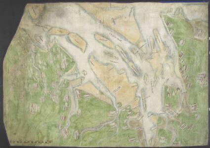
Mouths of the Thames and Medway from Ipswich to Sandwich and Maldon and Rochester to the Sea
This is a map showing the mouths of the Thames and the Medway from Ipswich to Sandwich and Maldon and Rochester to the sea. It dates from around 1544 and is annotated Rycherd Cavendishe made this carde’. Richard Cavendish was a master gunner who had supervised new defence works at Berwick and Wark in 1522-3. The map seems to have been made with the purposes of defence and navigation in mind. Coastal forts and navigational channels are shown. The shoreline is exaggerated in order to illustrate clearly how an enemy might move ashore and how they might be stopped. In this case the enemy was England’s ancient adversary France, with whom hostilities had resumed in 1542. This map of the vulnerable south east coast, was made against this historical background. The fear of a French invasion was very real. In 1514 the French had invaded Brighton, and in 1545 French ships entered the Solent and landed on the Isle of Wight. The lines which cover the sea areas of the map are called rhumb lines. These are lines of constant bearing that radiate from compass roses and allow the sailor to plot a course from harbour to harbour using dividers and straight edge. Vignettes of several towns are included on this map, Sandwich, Rochester and Canterbury are shown. The view of Essex is possibly derived from a survey Cavendish made in 1520. Other settlements are formalized showing rows of red roofed houses with a church in the centre. A scale bar annotated by 3’ is included, however, as this occupies a green painted area it is likely that this was added later. Cavendish, Richard
Essexiae Descriptio. The Description of Essex. [Karte], in: Novus atlas absolutissimus, Bd. 7, S. 265.
1 Karte aus Atlas Janssonius Offizin
Essexiae Descriptio. The Description of Essex. [Karte], in: Gerardi Mercatoris et I. Hondii Newer Atlas, oder, Grosses Weltbuch, Bd. 1, S. 93.
1 Karte aus Atlas Mercator, Gerhard und Hondius, Jodocus Jansson, Jan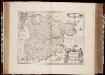
Essexiae descriptio = The description of Essex / [Joannes Janssonius]
1 : 220000 titelvariant: The description of Essex; Annotatie: Oorspr. verschenen in: Ioannis Ianssonii Novus Atlas ... - Amstelodami : apud Iohannem Ianssonium, 1646; Origineel is Blad 28 in atlas factice Janssonius, Joannes (jr.) (1588-1664) Amstelodami : sumptibus Ioannis Ianssonii
Essexia Comitatus. [Karte], in: Le théâtre du monde, ou, Nouvel atlas contenant les chartes et descriptions de tous les païs de la terre, Bd. 4, S. 244.
1 Karte aus Atlas Blaeu, Willem Janszoon und Blaeu, Joan Blaeu, Willem Janszoon
Essexia Comitatus. [Karte], in: Theatrum orbis terrarum, sive, Atlas novus, Bd. 4, S. 274.
1 Karte aus Atlas Blaeu, Joan Blaeu, Willem Janszoon
Essexia Comitatus. [Karte], in: Theatrum orbis terrarum, sive, Atlas novus, Bd. 4, S. 274.
1 Karte aus Atlas Blaeu, Joan Blaeu, Willem Janszoon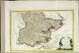
Provincia di Essex
1 Karte : Kupferdruck ; 18 x 29 cm Zatta presso Antonio Zatta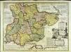
An accurate map of the county of Essex
1 Karte : Kupferdruck ; 51 x 69 cm Bowen; Hinton sold by Iohn Hinton at the Kings Arms in St. Pauls Church Yard
Essexiae descriptio = The description of Essex
1 : 160000 Amstelodami : sumptibus Joannis Janssonii
ESSEXIA | COMITATVS.
[Amsterdam : Joan Blaeu]
An accurate map of the county of Essex, divided into its hundreds
1 : 180000
ESSEXIAE COMITAT Sheet 12
This map of Essex is from the 1583 edition of the Saxton atlas of England and Wales. TThis atlas was first published as a whole in 1579. It consists of 35 coloured maps depicting the counties of England and Wales. The atlas is of great significance to British cartography as it set a standard of cartographic representation in Britain and the maps remained the basis for English county mapping, with few exceptions, until after 1750. During the reign of Elizabeth I map use became more common, with many government matters referring to increasingly accurate maps with consistent scales and symbols, made possible by advances in surveying techniques. Illustrating the increasing used of maps in government matters, Lord Burghley, Elizabeth I’s Secretary of State, who had been determined to have England and Wales mapped in detail from the 1550s, selected the cartographer Christopher Saxton to produce a detailed and consistent survey of the country. The financier of the project was Thomas Seckford Master of Requests at the Court of Elizabeth I, whose arms appear, along with the royal crest, on each map. Relief, in the form of uniform rounded representations of hills, is the main topographical feature presented in the maps. Rather than provide a scientific representation of relative relief these give a general impression of the lie of the land. Settlements and notable buildings are also recorded pictorially; a small building with a spire represents a village, while more important towns, such as Colchester are indicated by groups of buildings. London is shown in the bottom left hand corner and although at a small scale it is shown in some detail with St Paul’s Cathedral and London Bridge leading to Southwark clearly discernable. St Paul’s is correctly shown without its steeple which was destroyed by lightning in 1561 and was not replaced. Saxton, Christopher Ryther, Augustine
ESSEXIAE COMITAT f.36
This is a map of Essex by Christopher Saxton which dates from 1576. It forms part of an atlas that belonged to William Cecil Lord Burghley, Elizabeth I’s Secretary of State, whoused this atlas to illustrate domestic matters. This map is actually a proof copy of one which forms part of Christopher Saxton’s Atlas of England and Wales. This atlas was first published as a whole in 1579. It consists of 35 coloured maps depicting the counties of England and Wales. The atlas is of great significance to British cartography as it set a standard of cartographic representation in Britain and the maps remained the basis for English county mapping, with few exceptions, until after 1750. During the reign of Elizabeth I, map use became more common, with many government matters referring to increasingly accurate maps with consistent scales and symbols, made possible by advances in surveying techniques. Illustrating the increasing use of maps in government matters, Lord Burghley, who had been determined to have England and Wales mapped in detail from the 1550s, selected the cartographer Christopher Saxton to produce a detailed and consistent survey of the country. The financier of the project was Thomas Seckford Master of Requests at the Court of Elizabeth I, whose arms appear, along with the royal crest, on each map. Lord Burghley has added several place names to the map. At the mouth of the river Blackwater Lord Burghley has also written "Heyghfeld fayre and fatt, Barndon park better than that, Coppledon beares a Crown, Copthall best of all". The last-named is probably Sir Thomas Heneage's seat, near Epping in. Essex. The name of the engraver of the map has not been included but would have been one of a team of seven English and Flemish engravers employed to produce the copper plates for the atlas. Saxton, Christopher
Essex f. 10
This map of Essex is taken from a work entitled ""A CHOROGRAPHICALL description of the several Shires and Islands of Middlesex, Essex, Surrey, Sussex, Hamshire, Weighte, Garnesey and Jersey, performed by the travel and view of John Norden, 1595."" The map forms part of an omnibus volume of Norden's intended series of county guides, the Speculum Britanniae, which was never completed. It is dedicated to Elizabeth I, in whose reign the use of maps became more common. Under Elizabeth’s patronage the first, mostly accurate and detailed image of Britain was recorded by Christopher Saxton in his atlas of 1579. The volume that this map is from was meant for presentation to the Queen in the hope of securing her financial support for the project. This map of Essex is derived from Saxton’s work, in that relief is shown pictorially by small hill symbols, woodland and parks are shown by small trees, the later with a fence surrounding and surrounding counties are left blank. The main difference however between this and the Saxton maps is that this includes the road network and indicates the homes of the leading aristocracy and gentry. Roads are shown in beige, clearly linking the settlements, which are shown pictorially and highlighted with a red dot. London appears in the lower left corner. This development is significant as it shows the progression from a presentation of the county, to a means to practically navigate it. As a further tool in this endeavour the map is squared off with an Alpha numeric border. The depiction of roads and the orientation grid are derived from German prototypes. The Elizabethan coat of arms, appears to the left and sea monsters and ships provide decoration. Norden, John
Essexia comitatvs
1 Karte : Kupferdruck ; 40 x 51 cm Blaeu Joan Blaeu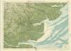
Essex, Sheet 26 - Bartholomew's "Half Inch to the Mile Maps" of England & Wales
1 : 126720 Topographic maps Bartholomew, John George John Bartholomew & Co
Essex, actually surveyed, with the several Roads
Lamb, Francis, Morgan, William, & Ogilby, John
Langley's new map of Essex
1 : 488000
A mapp of ye county of Essex, with its hundreds
1 : 250000
Southend-On-Sea - OS One-Inch Map
1 : 63360 Topographic maps Ordnance Survey Ordnance Survey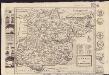
Essex
1 : 335000
Essex actually surveyed with the several Roads from London &c. ...
1 : 191000
Essex
1 : 200000
Colchester - OS One-Inch Map
1 : 63360 Topographic maps Ordnance Survey Ordnance Survey
Ipswich
1 : 31680 This drawing of parts of Essex and Suffolk is made up from four conjoined sheets mounted on stiff card. Verron's reputation as a surveyor suffered over the course of the survey. A letter from Survey Superintendent, William Mudge, dated 11 October 1820, reads: "Mr Stanley is going with me ...to Woodbridge to examine what is necessary to be done with Mr Verron's Plans...I apprehend they are much worse than... I expected." Verron