Maps of Açores

A New Chart of the Madeira and Canary Islands
1 : 1200000 Heather, W. (William) Heather, W. (William)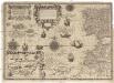
Cassiterides insulae vulgo Asores, & naucleris belgicis insulae Flandricae dictae, quod Brugenses Flandri, ipsas primi detexerint & habitaverint, cum antea incultissimae essent
1 : 548000 Azory Doetechum, Johannes Baptista van
Antilia, 1463.
Benincasa, Andrea
A chart of the Canary islands, including Madeira
Kanárské ostrovy Borda, Jean-Charles de Norie & Co.
INSULÆ | CANARIÆ, | Alias | FORTUNATÆ | dictæ.
[Amsterdam : Joan Blaeu]
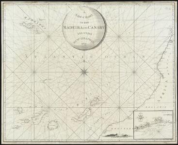
A chart of the Maderas and Canary Islands.
1 : 1770000 Jefferys, Thomas
Insula Canaria olim Fortunatae ... / Joannies Essensis
1 : 1000000 Annotatie: Met opgeplakte windroos en titelcartouche; Annotatie geografische gegevens: Oost boven Essen, Joan van [Antwerpen : J. van Essen]
Insulae Canariae, olim Fortunatae Dictae. [Karte], in: Novus atlas absolutissimus, Bd. 9, S. 247.
1 Karte aus Atlas Janssonius Offizin
Canary Ids.
1 : 2073600 Lucas, Fielding Jr.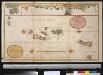
Afteekening van de Vlaamse Eijlanden met alle hunnen dieptens int groodt
Portugal Gerard van Keulen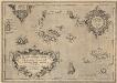
Açores Insulae. [Karte], in: Theatrum orbis terrarum, S. 92.
1 Karte aus Atlas Ortelius, Abraham Vrients, Jan Baptista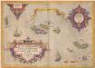
Açores Insulae. [Karte], in: Theatrum orbis terrarum, S. 45.
1 Karte aus Atlas Ortelius, Abraham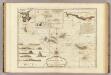
Chart of the Acores (Hawks) Islands.
1 : 1550000 Jefferys, Thomas
A new chart of the Azores or Western Isles
1 : 1020000 Heather, W. (William) Heather, W. (William)
Insulae Flandricae, olim Asores Dictae. [Karte], in: Novus atlas absolutissimus, Bd. 9, S. 244.
1 Karte aus Atlas Janssonius Offizin
INSULÆ | AÇORES
delineante | LUDOVICO TEISERA | Reg. Maj. Cosmographo. Amstelædami, | Excud. Joannes Blaeu.
Portuguese Islands in the Atlantic Ocean.
Fullarton, A. & Co.
Atlantic Islands.
Society for the Diffusion of Useful Knowledge (Great Britain)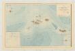
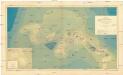
Carte bathymétrique des Iles Açores
1 : 660000 Thoulet, Marie Julien Olivier Imprimerie Vieillemard Fils et Cie.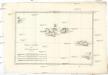
Isles Açores
1 : 1730000 Azory Bonne, Rigobert André
Iles Canaries et Madere. Afrique 5.
1 : 1641836 Vandermaelen, Philippe, 1795-1869
Azore Ids.
1 : 2300000 Lucas, Fielding Jr.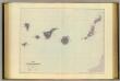
Canary Islands.
1 : 792000 Stanford, Edward
247. Atlantic Ocean Islands. The World Atlas.
1 : 2500000 USSR (Union of Soviet Socialist Republics).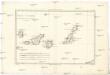
Isles Canaries
1 : 1720000 Kanárské ostrovy Bonne, Rigobert André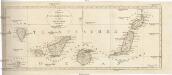
Neue CHARTE der CANARIEN INSELN
Kanárské ostrovy Bory de Saint-Vincent, Jean-Baptist Genevieve Marcellin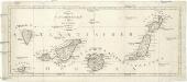
Neue Charte der Canarien Inseln
Kanárské ostrovy Bory de Saint-Vincent, Jean-Baptist Genevieve Marcellin
Madeira Ids.
1 : 1267200 Lucas, Fielding Jr.
[Islas Canarias - Segunda Hoja]
1 : 280000 Coello, Francisco [Verlag nicht ermittelbar]