Maps of Islas Canarias

Antilia, 1463.
Benincasa, Andrea
Nieuwe pas-caart; vertoonende, hoemen uyt de canaal, de custen van Portugael, Barbarijen, de Canarische en Vlaemsche eylanden beseylen zal
1 Karte : Kupferdruck ; 42 x 54 cm Doncker by Hendrick Doncker boekverkoper inde Nieubrugsteech in 't Stuurmans gereetschap
Cassiterides insulae vulgo Asores, & naucleris belgicis insulae Flandricae dictae, quod Brugenses Flandri, ipsas primi detexerint & habitaverint, cum antea incultissimae essent
1 : 548000 Azory Doetechum, Johannes Baptista van
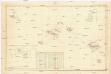
A New Chart of the Madeira and Canary Islands
1 : 1200000 Heather, W. (William) Heather, W. (William)
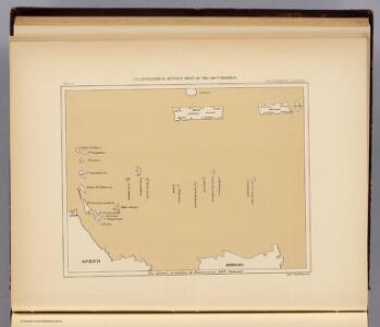
Carte pour resoudre les six problemes 1749
1 : 15000000 Mollova mapová sbírka
A chart of the Canary islands, including Madeira
Kanárské ostrovy Borda, Jean-Charles de Norie & Co.
[XVI], uit: Geognostische Karte des Oesterreichischen Kaiserstaates mit einem grossen Theile Deutschland's u. Italien / hauptsachlich nach ... Haidinger's geognostischer Karte dieses Staates bearb. von Josef Scheda
1 : 3000000 titelvariant: General-Karte von Europa in 25 Blättern; Annotatie: Bijlage bij: General-Karte von Europa in 25 Blättern. - 1:2.592.000. - 1845-1847 Scheda, Joseph Wien : K.K. Militär. Geografisch. Institut
Een gedeelte van de Spaanse Zee van t Canaal tot t Naauw van de Straat
Portugal Gerard van Keulen
Fessae, Et Marocchi Regna Africae Celeberr. [Karte] Congi Regni Christiani, In Africa, Nova Descriptio. [Nebenkarte], in: Theatrum orbis terrarum, S. 421.
1 Karte aus Atlas Ortelius, Abraham Vrients, Jan Baptista

Fessae et Marocchi Regna. [Karte], in: Gerardi Mercatoris Atlas, sive, Cosmographicae meditationes de fabrica mundi et fabricati figura, S. 502.
1 Karte aus Atlas Mercator, Gerhard Montanus, Petrus
Fessae, Et Marocchi Regna Africae Celeberr. [Karte] Congi Regni Christiani, In Africa, Nova Descriptio. [Nebenkarte], in: Theatrum orbis terrarum, S. 320.
1 Karte aus Atlas Ortelius, Abraham
A chart of the Maderas and Canary Islands.
1 : 1770000 Jefferys, Thomas
INSULÆ | CANARIÆ, | Alias | FORTUNATÆ | dictæ.
[Amsterdam : Joan Blaeu]
Insulae Canariae, olim Fortunatae Dictae. [Karte], in: Novus atlas absolutissimus, Bd. 9, S. 247.
1 Karte aus Atlas Janssonius Offizin
Insula Canaria olim Fortunatae ... / Joannies Essensis
1 : 1000000 Annotatie: Met opgeplakte windroos en titelcartouche; Annotatie geografische gegevens: Oost boven Essen, Joan van [Antwerpen : J. van Essen]
Iles Canaries et Madere. Afrique 5.
1 : 1641836 Vandermaelen, Philippe, 1795-1869
Neueste Karte von Portugal
Grosser Hand-Atlas über alle Theile der Erde in 170 Karten Meyer, J. Verlag des Bibliographischen Instituts
Partie, Desert de Sahara. Afrique 6.
1 : 1641836 Vandermaelen, Philippe, 1795-1869
Feuille 29 (A V), uit: Carte géologique internationale de l'Europe : la carte, votée au congrès géologique international de Bologne en 1881, est exécutée conformément aux décisions d'une commission internationale, avec le concours des gouvernements, sous le dir. de M.M. Beyrich et Hauchecorne
Annotatie: Blad 48 gamme des couleurs; blad 49: bladwijzer en titelblad Heinrich Ernst Beyrich 1815-1896; Wi. Hauchecorne Berlin : Reimer / (Berlin: Institut lithographique)
Itinéraires du yacht "Princesse Alice" dans l'archipel des Açores, 1895,1896,1897
Azory (Portugalsko : souostroví) Tollemer, A. Imprimerie Vieillemard
Nord-Atlantischer Ozean
1 : 750000 Afrika Reichs-Marine-Amt
Carte réduite des costes d'Espagne et de Portugal
1 Karte : Kupferdruck ; 87 x 54 cm Bellin s.n.
Insulae Flandricae, olim Asores Dictae. [Karte], in: Novus atlas absolutissimus, Bd. 9, S. 244.
1 Karte aus Atlas Janssonius Offizin
Spain & Portugal - western section.
1 : 2000000 John Bartholomew and Son
Hispaniæ, et Portugalliæ maritimi tractus, à S. Andero, ad Malagam
1 Karte : Kupferdruck ; 47 x 56 cm Renard Louis Renard
Portugalliæ et Algarbiæ regna
1 Karte : Kupferdruck ; 48 x 56 cm Seutter Matthäus Seutter
Portugalliæ et Algarbiæ cum finitimis Hispanniæ regnis
1 Karte : Kupferdruck ; 48 x 54 cm Homann Johann Baptist Homann