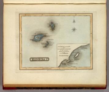
Maps of Funchal (Sé)

Madeira Ids.
1 : 1267200 Lucas, Fielding Jr.
Afteekeningh van t eijland Madera en Porto int groodt
Portugal Gerard van Keulen
De reede van Marasijla Fonsijael en St. Cruz int groodt
Canary Islands Gerard van Keulen
Madeira.
1 : 190000 Stanford, Edward
Physical map of the Island of Madeira
1 : 100000 Ziegler, Jakob Melchior ; Steiner, P. ; Leuzinger, Rudolf E. Standford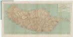
[Kaart], uit: General map of the Island of Madeira / constructed by C.A. le P. Power from other maps, greatly improved, corr. and brought up to date 1919
1 : 100000 titelvariant: Map of the Island of Madeira; Annotatie: Titel op omslag: Map of the Island of Madeira; Met plaatsnamenregister geplakt aan binnenzijde van de omslag Charles A. de P. Power London : George Philip & Son
Insulae Canariae, olim Fortunatae Dictae. [Karte], in: Novus atlas absolutissimus, Bd. 9, S. 247.
1 Karte aus Atlas Janssonius Offizin
Insula Canaria olim Fortunatae ... / Joannies Essensis
1 : 1000000 Annotatie: Met opgeplakte windroos en titelcartouche; Annotatie geografische gegevens: Oost boven Essen, Joan van [Antwerpen : J. van Essen]
INSULÆ | CANARIÆ, | Alias | FORTUNATÆ | dictæ.
[Amsterdam : Joan Blaeu]
A chart of the Maderas and Canary Islands.
1 : 1770000 Jefferys, Thomas
Fessae, Et Marocchi Regna Africae Celeberr. [Karte] Congi Regni Christiani, In Africa, Nova Descriptio. [Nebenkarte], in: Theatrum orbis terrarum, S. 320.
1 Karte aus Atlas Ortelius, Abraham
Fessae, Et Marocchi Regna Africae Celeberr. [Karte] Congi Regni Christiani, In Africa, Nova Descriptio. [Nebenkarte], in: Theatrum orbis terrarum, S. 421.
1 Karte aus Atlas Ortelius, Abraham Vrients, Jan Baptista

Fessae et Marocchi Regna. [Karte], in: Gerardi Mercatoris Atlas, sive, Cosmographicae meditationes de fabrica mundi et fabricati figura, S. 502.
1 Karte aus Atlas Mercator, Gerhard Montanus, Petrus
Karte von Fes und Marócos
Fez (Maroko) Canzler, Friedrich Gottlieb Haest in der Weigel- und Schneiderschen Handlung
A New Chart of the Madeira and Canary Islands
1 : 1200000 Heather, W. (William) Heather, W. (William)
Islands In The Atlantic.
1 : 285120 Tallis, J. & F.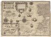
Cassiterides insulae vulgo Asores, & naucleris belgicis insulae Flandricae dictae, quod Brugenses Flandri, ipsas primi detexerint & habitaverint, cum antea incultissimae essent
1 : 548000 Azory Doetechum, Johannes Baptista van
Antilia, 1463.
Benincasa, Andrea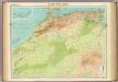
North-west Africa.
1 : 5000000 John Bartholomew and Son
Karte von der westlichen kuste von Africa : von der strasse bey Gibraltar bis zu dem XI grade norderbreite ...wahrnehmungen entworfen
1 : 1
A chart of the western coast of Africa, from the Straits of Gibraltar to eleven degrees of north latitude, including the Canary & Cape Verd Islands
1 : 13000000
Partie occidentale de l'Afrique
1 : 9600000 Afrika západní Bonne, Rigobert André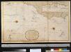
Generaale kaart van de kust van Barbarija van Portugaal tot Cabo Verde als ook de Carnarisse, Vlaamse en Zoute Eijl.
Atlantic Ocean Gerard van Keulen
Spezial-Karte von Afrika
1 : 4000000 Blatt 1 Habenicht, Hermann Perthes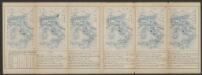
Tabula Europae II. [Karte], in: Claud. Ptolemaeus. Geographia lat. cum mappis [...], S. 257.
1 Karte aus Atlas Münster, Sebastian [und Ptolemaeus, Claudius]
Barbariae et Guineae maritimi à freto Gibraltar ad fluvium Gambiae cum Insulis Salfis Flandrisis et Canaricis
1 : 55000000
De cust van Barbaria, Gualata, Arguyn en Geneheo van Capo S Vincente tot Capo Verde
1 : 6000000
Barbariæ et Guineæ maritimi à freto Gibraltar ad fluvium Gambiæ
1 Karte : Kupferdruck ; 47 x 56 cm Renard apud L. Renard