Maps of Algeria

[Quator Affrice tabula] [Karte], in: Clavdii Ptholomei Viri Alexandrini Cosmographie, S. 158.
1 Karte aus Atlas Nicolaus Germanus [und Ptolemaeus, Claudius]
Afrique Septentrionale, Malte, Acores, Madere, Canaries.
1 : 7500000 Garnier, F. A., 1803-1863
Aphrica Tabula I. [Karte], in: Claud. Ptolemaeus. Geographia lat. cum mappis [...], S. 283.
1 Karte aus Atlas Münster, Sebastian [und Ptolemaeus, Claudius]
Barbarie Et Biledulgerid, Nova Descriptio. [Karte], in: Theatrum orbis terrarum, S. 418.
1 Karte aus Atlas Ortelius, Abraham Vrients, Jan Baptista
Mediterranean Sea W.
1 : 9000000 Andree, Richard; Times (London, England)
Mittelmeerlander westliche.
1 : 9000000 Andree, Richard
Nordwestliches Africa
Neuer Handatlas über alle Theile der Erde Kiepert, Heinrich Verlag von Dietrich Reimer
Barbariae Et Biledulgerid, Nova Descriptio. [Karte], in: Theatrum orbis terrarum, S. 122.
1 Karte aus Atlas Ortelius, Abraham
Tabula Prima Africae. [Karte], in: Claudii Ptolemei viri Alexandrini mathematice discipline philosophi doctissimi geographie opus [...], S. 181.
1 Karte aus Atlas Waldseemüller, Martin [und Ptolemaeus, Claudius] Übelin, Georg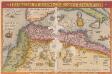
Barbarie Et Biledulgerid, Nova Descriptio. [Karte], in: Theatrum orbis terrarum, S. 317.
1 Karte aus Atlas Ortelius, Abraham
[Das Mittelländische Meer und Nord-Afrika, Westliches Blatt]
Hand-Atlas über alle Theile der Erde und über das Weltgebäude Stieler, Adolf Justus Perthes
[Das Mittelländische Meer und Nord-Afrika]
Handatlas über alle Theile der Erde und über das Weltgebäude Stieler, Adolf Justus Perthes
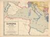
Das Mittellandische Meer Und Nord-Afrika.
1 : 7500000 Petermann, A.
Das Mittelländische Meer
Stieler's Hand-Atlas Stieler, Adolf bei Justus Perthes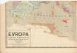
Evropa raného středověku: do konce VI. století po Kr.
Kašpar, Jan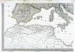
Carte d'Europe ou sont tracées les limites des empires, royaumes, et etats souverains, feuille 5
1 Blatt : 56 x 87 cm Semen etc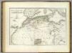
Nordwest. Africa.
1 : 6325000 Weiland, C. F. (Carl Ferdinand), d. 1847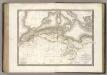
La Barbarie.
1 : 6500000 Lapie, M. (Pierre), 1779-1850
Das Nordwestliche Africa enthaltend die Staaten Fez und Marokko, Algier, Tunis und Tripoli, die Sahara, Canarischen und Azorischen Inseln oder Atlas-Land und Tiefland von Africa
1 : 6325000 entw. und gezeichnet von C. F. Weiland C. Jungmann sc. Weimar : Verlag des Geograph. Instituts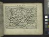
Spain.
from Abraham Ortelius his epitome of the theater of the worlde / nowe latlye ... renewed and augmented ... by Micheal Coignet, mathematitian of Antwarpe.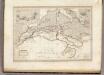
Afrique Septentrionale.
1 : 8000000 Montemont, A.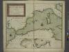
A new chart of the coast of the MEDITERRANEAN SEA
from The sea-atlas : containing an hydrographical description of most of the sea-coasts of the known parts of the world.
In notitiam ecclesiasticam Africae tabula geographica
1 : 4500000 L'Isle, Guillaume de, 1675-1726 Apud Auctorem, Via vulgo dicta des Canettes propè Sancti Sulpitii fanum
Aphrica Tabula I. [Karte], in: Geographia universalis vetus et nova complectens Claudii Ptolemaei Alexandrini enarrationis libros VIII, S. 254.
1 Karte aus Atlas Münster, Sebastian [und Ptolemaeus, Claudius]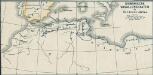
Osmanische Vasallenstaaten in Nordwest-Afrika
1 : 27000000 Osmanisches Reich, Maghreb , Protektorat
Nord-Africa Berberei
1 : 9678000 Afrika severní Schlieben Gleditsch
Africae tabula geographica.
1 : 5700000 L'Isle, Guillaume de, 1675-1726
In notitiam ecclesiasticam Africæ tabula geographica
1 : 5700000
Europa befolkningskarta
![[Quator Affrice tabula] [Karte], in: Clavdii Ptholomei Viri Alexandrini Cosmographie, S. 158.](https://images-2.georeferencer.com/images/iiif/038393184748/full/,300/0/native.jpg)

