Maps of Vaud

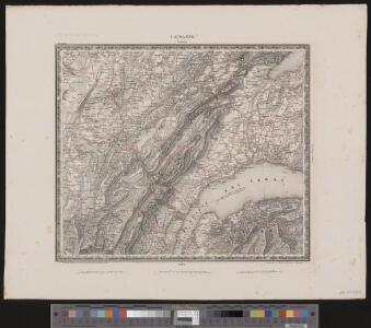
Lausanne
1 : 200000 1 Karte entworfen und bearbeitet von Woerl ; in Stein gestochen unter seiner Leitung 1835 ; Lithographie von B. Herder Herder, Freiburg im Breisgau
Partie méridionale du comté de Bourgogne ou Franche-Comté
1 Karte : Kupferdruck ; 46 x 55 cm Robert de Vaugondy G. et D. Robert de Vaugondy
Atlas de la Suisse
1 : 450000 1 Atlas (19 Bl.) dessiné par MM. H. Keller, Scheurmann, Pfyffer d'Altishofen, Osterwald, etc. ; gravé par M. Scheurmann Orell Füssli & Co., Zürich
Comte de Bourgogne sud.
1 : 237500 Robert de Vaugondy, Gilles, 1688-1766
Atlas der Schweiz
1 : 450000 1 Atlas (18 Bl.) gez. u. gest. v. J. Scheurmann Orell Fussli, Zurich
Atlas der alten Eidgenossenschaft in 20 Karten: Republik Genf sowie Genferseeregion
Originaltitel: Carte du Lac de Geneve et des Pays circonvoisins avec le Territoire de la République de Geneve et du Plan de la ditte Ville. Mit Erklärung der Zeichen und Nebenkarte der Stadt Genf. Bearbeitung: Rizzi Zannoni, Joh. Ant., Professor der Mathematik und Geografie Herausgeber: Homännische Erben
Le Theatre de Bellone :
Mollova mapová sbírka Schenk, Pieter Braakman, Adriaan
[Exactissima Helvetiae, Rhaetiae, Valesiae ... tabula]
1 : 850000 9 Karten [Kopie von Adrian Braakman] [chez Pierre Schenk et Adrian Braakman], [Amsterdam]
Carte de la Suisse Romande qui comprend le Pays de Vaud et le gouvernement d'Aigle, dépendant du canton de Berne
1 : 90000 Mallet-Prévost, Henri chez F. Monty
Taschen-Atlas der Schweiz
1 Atlas (25 S., 20 Taf.) gezeichnet und gestochen von Emil Wagner = Atlas de poche de la Suisse : 26 cartes en couleurs / dessinées et gravées par Émile Wagner Eggimann, Genf

<<Le>> canton de Vaud
1 : 390000 1 Karte dessiné par H. Keller ; gravé par J.J. Scheurmann Orell Fussli & Comp., Zurich
<<Le>> canton de Vaud
1 : 390000 1 Karte dessiné par H. Keller ; gravé par J.J. Scheurmann Orell Fussli & Comp., Zurich
Carte des cantons de Genève, Vaud, Neuchâtel et Fribourg
1 : 250000 1 Karte Topogr. Anstalt von Wurster, Randegger und Co. Wurster, Zürich
<<Le>> canton de Vaud
1 : 390000 1 Karte dessiné par H. Keller ; gravé par J.J. Scheurmann Orell Fussli et Comp., Zurich
Atlas novus Reipublicae Helveticae
1 Atlas ([40] Bl., 97 S.) bey Orell, Gessner und Compagnie, Zürich
<<Le>> canton de Vaud
1 : 390000 1 Karte dessiné par H. Keller ; gravé par J.J. Scheurmann Orell Fussli & Comp., Zurich
<<Le>> canton de Vaud
1 : 390000 1 Karte dessiné par H. Keller ; gravé par J.J. Scheurmann Orell Fussli et Comp., Zurich
Carte du canton de Vaud
1 : 200000 Artistische Anstalt F. Malté (Stuttgart) publiée par F. Weber
Le Canton de Vaud - Canton Waadt

canton de Vaud
1 : 390000 Keller, Heinrich ; Scheuermann, Johann Jakob Orell Fussli & Comp.
Plus grande partie de la Suisse Romande ou République Lémanique.
From Atlas Suisse. Levé et dessiné par J. H. Weiss aux fraix de J. R. Meyer á Aarau dans les années 1786 á 1802. Gravée par Guerin, Eichler, et Scheurmann.
Novissima totius Lavsonii sive Lemani Lacvs
1 : 180000 Mollova mapová sbírka Chopy, Antoine Homann, Johann Baptista - dědici

Atlas Suisse
1 : 120000 16 Karten levé et dessiné par J.H. Weiss [et Joachim Eugen Müller] aux frais de J.R. Meyer à Aarau dans les années 1786 à 1802 ; gravée [sic] par [Christophe] Guérin, [Matthias Gottfried] Eichler et [Johann Jakob] Scheurmann [Johann Rudolf Meyer], Aarau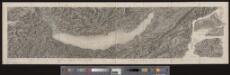
[Malerisches Relief der Schweizer- und angränzenden Alpen]
1 : 135000 11 Vogelschaukarten Nach der Natur aufgenommen und gezeichnet von F.W. Delkeskamp ; gestochen v. Knopfmacher u. J.Ph. Dauch [Friedrich Wilhelm Delkeskamp], [Frankfurt am Main]
Carte du canton de Vaud
1 : 200000 Reber, ... ; Zwahlen, J. Barbey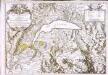
Carte du lac de Geneve et des pays circonvoisins
1 Karte auf 2 Blatt : Kupferdruck ; 55 x 80 cm Rovéréa; Fatio de Duillier; Daudet; Chopy Antoine Chopy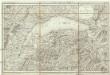
Carte du Lac de Geneve et de ses environs
1 : 320000 Ženeva (Švýcarsko : kanton)