Maps of Upper Palatinate

Palatinatus Bavariae Descriptio [Karte], in: Theatrum orbis terrarum, S. 174.
1 Karte aus Atlas Ortelius, Abraham
Palatinatus Bavariae Descriptio [Karte], in: Theatrum orbis terrarum, S. 266.
1 Karte aus Atlas Ortelius, Abraham Vrients, Jan Baptista
Palatinatus Bavariae Descriptio [Karte], in: Theatrum orbis terrarum, S. 74.
1 Karte aus Atlas Ortelius, Abraham
1:500,000 Europe (Air) G.S.G.S. No. 4072, Munchen
Sheet NE48-10 from the map series: 1:500,000 Europe (Air) G.S.G.S. No. 4072.
Delineatio Nordgoviae Veteris prout ejus facies Seculo XI. & XII.
1 : 540000 Mollova mapová sbírka Falckenstein, Johann Heinrich von Homann, Johann Baptista - dědici
Nordgaviæ veteris delineatio
1 Karte : Kupferdruck ; 45 x 53 cm Falckenstein; Enderes in lucem autem emissa a Iohanne Iacobo Enderes
Historia Circuli Bavarici nec non finitimarum ac insertarum Regionum
1 : 650000 Mollova mapová sbírka Seutter, Matthäus Seutter, Matthäus
Historia Circuli Bavarici nec non finitimarum ac insertarum Regionum
1 : 650000 Mollova mapová sbírka Seutter, Matthäus Seutter, Matthäus
Delineatio Nordgoviæ veteris
1 Karte : Kupferdruck ; 44 x 53 cm Falckenstein Homännische Erben
Cercle de Baviere
1 Karte auf 2 Blatt : Kupferdruck ; 55 x 42 cm Nolin; Guérard; Leonard Nolin r. St. Iacque a l'ens. de la place des victoires, chez I. Leonard rüe de la cour
Historia circuli Bavarici, nec non finitimarum, ac insertarum regionum
1 Karte : Kupferdruck ; 54 x 47 cm + Lotter Tobias Konrad Lotter
Circolo di Baviera diuiso ne Stati, che lo compongono particolarmente in quelli, che spettano all Elettore di Bauiera, al Duca di Neoburg, ora Palatino del Reno, et al Palatino di Sulzbach tutti d'una medesima Famiglia
1 : 630000 Mollova mapová sbírka Cantelli, Giacomo Pietrasanta, Gasparo De Rossi, Giovanni Giacomo
Cercle de Baviere Divisé par Etats particulierement ceux qui apartiennent A L'Electeur de Baviere au Duc de Neubourg au jour d'huy Palatin du Rhin et au palatin de Sulzbach Tous d'une même Famille. Comprenant aussi L'Archevéché de Saltzbourgh Les Evechez de Passau, Freisingen et Regenspurg. &c.
1 : 635000 Mollova mapová sbírka Nolin, Jean-Baptiste Nolin, Jean-Baptiste I.
Circulus Bavariae in suas quasque dition. tam cum finitimis quam insertis Regionibus accuratissime divise
1 : 1300000 Mollova mapová sbírka Seutter, Matthäus Lotter, Tobias Conrad Seutter, Matthäus
Palatinatus Bavariæ
1 Karte : Kupferdruck ; 19 x 29 cm Merian Merian
Le cercle de Baviere
1 Karte : Kupferdruck ; 47 x 44 cm Robert de Vaugondy G. et D. Robert de Vaugondy
Circulus Bavaricus oder Geographische Grundlegung des Bairischen Craisses Sambt Angraenzenden Laendern Alles aus den besten Authoribus Ordentlich u. fleissig zusamen getragen
1 : 580000 Mollova mapová sbírka Wolf, Jeremias Wolff, Jeremias
Historia circuli Bavarici nec non finitimarum ac insertarum regionum
Bavorsko (Německo) Lotter, Tobias Conrad â Tob. Conrado Lotter
Neue Geographische Land-Karte, In welcher das gantze Chur-Hertzogthum Ober und Nieder Bayren, sambt der gantzen Ober Bayrischen Pfaltz, etc. auch allen inländische. vornembsten Gräntz Scheidungen, und daran stoßenden Ländern, Post-Straßen etc. auf daß deutlicheste vorgestellet wird
1 : 750000 Mollova mapová sbírka Lidl, Johann Jacob
S. R. I. Bavariæ circulus atq[ue] electoratus tam cum adjacentibus quam insertis regionibus
1 Karte : Kupferdruck ; 56 x 45 cm Visscher Nicolaes Visscher
Le cercle de Baviere
1 Karte : Kupferdruck ; 61 x 49 cm Condet chez Cóvens et Mortier
Neue geographische Land-Karte in welcher das gantze Chur-Herzogthum Ober und Nieder Bayren, sambt der gantzen Ober Bayrischen Pfaltz, etc. auch allen inländischen vornembsten Gräntz Scheidungen, und daran stoßenden Ländern, Post-Straßen etc. auf daß deutlichste vorgestellet wird
1 : 900000 Bavorsko (Německo) Lidl, Johann Jakob J.J. Lidl
Circulus Bavaricus oder geographische Grundlegung des Bairischen Craisses sambt angrænzenden Lændern
1 Karte : Kupferdruck ; 58 x 43 cm Lotter zu finden bey Tobias Conrad Lotter
Bavaria Superior et Inferior cum Quatuor Praefecturis juxta recentißimam Designationem ob oculos posita
1 : 475000 Mollova mapová sbírka Seutter, Matthäus Seutter, Matthäus
Sect. 24: Regensburg, uit: Geologische Karte des Deutschen Reichs in 27 Blaettern / [von] Richard Lepsius ; Red. von C. Vogel
1 : 500000 Annotatie: Blad 18 ontbreekt; Een aantal bladen op linnen; Een aantal bladen gereviseerd 1913-1914; Annotatie geografische gegevens: Met schaalstokken o.a. in kilometers; Legenda Carl Vogel 1828-1897 Gotha : Justus Perthes
Pars III. proponit exteriores præfecturas dicasterio Straubingensi subjectas cum limitibus regni Bohemiæ adjacentis
1 Karte : 54 x 52 cm Heinrich Ludwig Broenner
Palatinatvs Bavariae descriptio
1 Karte : Kupferdruck ; 26 x 24 cm Reich; Ortelius; Hogenberg s.n.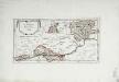
![Palatinatus Bavariae Descriptio [Karte], in: Theatrum orbis terrarum, S. 174.](https://images-2.georeferencer.com/images/iiif/559483072546/full/,300/0/native.jpg)

