Maps of Upper Palatinate

Sect. 24: Regensburg, uit: Geologische Karte des Deutschen Reichs in 27 Blaettern / [von] Richard Lepsius ; Red. von C. Vogel
1 : 500000 Annotatie: Blad 18 ontbreekt; Een aantal bladen op linnen; Een aantal bladen gereviseerd 1913-1914; Annotatie geografische gegevens: Met schaalstokken o.a. in kilometers; Legenda Carl Vogel 1828-1897 Gotha : Justus Perthes
Pars III. proponit exteriores præfecturas dicasterio Straubingensi subjectas cum limitibus regni Bohemiæ adjacentis
1 Karte : 54 x 52 cm Heinrich Ludwig Broenner
Palatinatus Bavariæ
1 Karte : Kupferdruck ; 19 x 29 cm Merian Merian
Palatinatus Bavariae Descriptio [Karte], in: Theatrum orbis terrarum, S. 266.
1 Karte aus Atlas Ortelius, Abraham Vrients, Jan Baptista
Palatinatvs Bavariae descriptio
1 Karte : Kupferdruck ; 26 x 24 cm Reich; Ortelius; Hogenberg s.n.
Bavaria Superior et Inferior cum Quatuor Praefecturis juxta recentißimam Designationem ob oculos posita
1 : 475000 Mollova mapová sbírka Seutter, Matthäus Seutter, Matthäus
Neue Geographische Land-Karte, In welcher das gantze Chur-Hertzogthum Ober und Nieder Bayren, sambt der gantzen Ober Bayrischen Pfaltz, etc. auch allen inländische. vornembsten Gräntz Scheidungen, und daran stoßenden Ländern, Post-Straßen etc. auf daß deutlicheste vorgestellet wird
1 : 750000 Mollova mapová sbírka Lidl, Johann Jacob
Palatinatus Bavariae Descriptio [Karte], in: Theatrum orbis terrarum, S. 174.
1 Karte aus Atlas Ortelius, Abraham
Delineatio Nordgoviae Veteris prout ejus facies Seculo XI. & XII.
1 : 540000 Mollova mapová sbírka Falckenstein, Johann Heinrich von Homann, Johann Baptista - dědici
Palatinatus Bavariae Descriptio [Karte], in: Theatrum orbis terrarum, S. 74.
1 Karte aus Atlas Ortelius, Abraham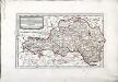
Des Herzogthums Niederbayern Pfleggerichte Kelhaim, Dietfurt, Abach, Haidau, Stadt am Hof, Straubing, Miterfels, Cham, Furt, Kötzting, Neukirchen, Viechtach, Leonsberg, Schwarzach, Linden, Zwisel, Regen, Deckendorf, Hengersberg, Winzen, Diessenstein und Bernstein oder das Rentamt Straubing
1 Karte : Kupferdruck ; 20 x 34 cm Reilly F. J. J. von Reilly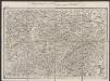
Palatinatus Bavariae [Karte], in: Gerardi Mercatoris Atlas, sive, Cosmographicae meditationes de fabrica mundi et fabricati figura, S. 388.
1 Karte aus Atlas Mercator, Gerhard Montanus, Petrus
Bavariae pars inferior
1 Karte : Kupferdruck ; 46 x 56 cm Homann Johann Baptist Homann
Sbírka map a diagramů použitých na mírových konferencích v Paříži v letech 1919 - 1920

Bavariæ pars inferior
1 Karte : Kupferdruck ; 47 x 56 cm Seutter Matthäus Seutter
Nr. 17 Franken - Oberpfalz [kaart], uit: Shell Strassenkarte
1 : 470000 Annotatie: Voor aanwezige bladen zie overzichtsblad; Incompleet [S.l. : Shell Reisedienst]
Generalkarte von Zentraleuropa

Palatinatus Bavariae. [Karte], in: Novus Atlas, das ist, Weltbeschreibung, Bd. 1, S. 225.
1 Karte aus Atlas Blaeu, Joan Blaeu, Willem Janszoon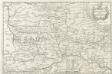
Palatinatus Bavariae
1 : 760000 Mollova mapová sbírka Merian, Matthaeus Merian, Matthäus
Palatinatus Bavariae. [Karte], in: Theatrum orbis terrarum, sive, Atlas novus, Bd. 1, S. 266.
1 Karte aus Atlas Blaeu, Joan Blaeu, Willem Janszoon
Palatinatus Bavariae. [Karte], in: Le théâtre du monde, ou, Nouvel atlas contenant les chartes et descriptions de tous les païs de la terre, Bd. 1, S. 251.
1 Karte aus Atlas Blaeu, Willem Janszoon und Blaeu, Joan Blaeu, Willem Janszoon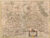
Palatinatus Bavariae. [Karte], in: Novus atlas absolutissimus, Bd. 2, S. 226.
1 Karte aus Atlas Janssonius Offizin
Palatinatvs Bavariae 1596
1 Karte : Kupferdruck ; 21 x 29 cm Quad; Bussemacher ex officina Ioannis Bussemechers
Die nordbairische Mundart von Jamburg a. Dnjepr
Oberpfalz Mundart, Nordbairisch Schirmunski, V.
Palatinatus Bavariae. [Karte], in: Gerardi Mercatoris et I. Hondii Newer Atlas, oder, Grosses Weltbuch, Bd. 1, S. 307.
1 Karte aus Atlas Mercator, Gerhard und Hondius, Jodocus Jansson, Jan

PALATINATVS | BAVARIÆ.
Amsterdami | Excudit Guiljelmus Blaeuw.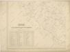
![Sect. 24: Regensburg, uit: Geologische Karte des Deutschen Reichs in 27 Blaettern / [von] Richard Lepsius ; Red. von C. Vogel](https://images-2.georeferencer.com/images/iiif/293820470889/full/,300/0/native.jpg)

