Maps of Upper Palatinate

Pars III. proponit exteriores præfecturas dicasterio Straubingensi subjectas cum limitibus regni Bohemiæ adjacentis
1 Karte : 54 x 52 cm Heinrich Ludwig Broenner
Sect. 24: Regensburg, uit: Geologische Karte des Deutschen Reichs in 27 Blaettern / [von] Richard Lepsius ; Red. von C. Vogel
1 : 500000 Annotatie: Blad 18 ontbreekt; Een aantal bladen op linnen; Een aantal bladen gereviseerd 1913-1914; Annotatie geografische gegevens: Met schaalstokken o.a. in kilometers; Legenda Carl Vogel 1828-1897 Gotha : Justus Perthes
Palatinatus Bavariæ
1 Karte : Kupferdruck ; 19 x 29 cm Merian Merian
Palatinatvs Bavariae descriptio
1 Karte : Kupferdruck ; 26 x 24 cm Reich; Ortelius; Hogenberg s.n.
Delineatio Nordgoviae Veteris prout ejus facies Seculo XI. & XII.
1 : 540000 Mollova mapová sbírka Falckenstein, Johann Heinrich von Homann, Johann Baptista - dědici
Palatinatus Bavariae Descriptio [Karte], in: Theatrum orbis terrarum, S. 266.
1 Karte aus Atlas Ortelius, Abraham Vrients, Jan Baptista
Neue Geographische Land-Karte, In welcher das gantze Chur-Hertzogthum Ober und Nieder Bayren, sambt der gantzen Ober Bayrischen Pfaltz, etc. auch allen inländische. vornembsten Gräntz Scheidungen, und daran stoßenden Ländern, Post-Straßen etc. auf daß deutlicheste vorgestellet wird
1 : 750000 Mollova mapová sbírka Lidl, Johann Jacob
Palatinatus Bavariae Descriptio [Karte], in: Theatrum orbis terrarum, S. 174.
1 Karte aus Atlas Ortelius, Abraham
Palatinatus Bavariae Descriptio [Karte], in: Theatrum orbis terrarum, S. 74.
1 Karte aus Atlas Ortelius, Abraham
Bavaria Superior et Inferior cum Quatuor Praefecturis juxta recentißimam Designationem ob oculos posita
1 : 475000 Mollova mapová sbírka Seutter, Matthäus Seutter, Matthäus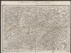
Palatinatus Bavariae [Karte], in: Gerardi Mercatoris Atlas, sive, Cosmographicae meditationes de fabrica mundi et fabricati figura, S. 388.
1 Karte aus Atlas Mercator, Gerhard Montanus, Petrus
Palatinatus Bavariae. [Karte], in: Novus Atlas, das ist, Weltbeschreibung, Bd. 1, S. 225.
1 Karte aus Atlas Blaeu, Joan Blaeu, Willem Janszoon
Palatinatus Bavariae. [Karte], in: Theatrum orbis terrarum, sive, Atlas novus, Bd. 1, S. 266.
1 Karte aus Atlas Blaeu, Joan Blaeu, Willem Janszoon
Sbírka map a diagramů použitých na mírových konferencích v Paříži v letech 1919 - 1920

Provincia Pilsnensis
1 : 217000 Mollova mapová sbírka Erber, Bernardinus Winkler, Johann Christoph Kurzböck, Josef von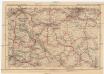
Deutsches Reich, Tschecho-Slowakei
1 : 600000 Německo Koch, Wilhelm Opitz, Carl Arnd
Nr. 17 Franken - Oberpfalz [kaart], uit: Shell Strassenkarte
1 : 470000 Annotatie: Voor aanwezige bladen zie overzichtsblad; Incompleet [S.l. : Shell Reisedienst]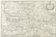
Palatinatus Bavariae
1 : 760000 Mollova mapová sbírka Merian, Matthaeus Merian, Matthäus
Generalkarte von Zentraleuropa

Palatinatus Bavariae. [Karte], in: Le théâtre du monde, ou, Nouvel atlas contenant les chartes et descriptions de tous les païs de la terre, Bd. 1, S. 251.
1 Karte aus Atlas Blaeu, Willem Janszoon und Blaeu, Joan Blaeu, Willem Janszoon
Palatinatus Bavariae. [Karte], in: Novus atlas absolutissimus, Bd. 2, S. 226.
1 Karte aus Atlas Janssonius Offizin
Palatinatvs Bavariae 1596
1 Karte : Kupferdruck ; 21 x 29 cm Quad; Bussemacher ex officina Ioannis Bussemechers
Palatinatus Bavariae. [Karte], in: Gerardi Mercatoris et I. Hondii Newer Atlas, oder, Grosses Weltbuch, Bd. 1, S. 307.
1 Karte aus Atlas Mercator, Gerhard und Hondius, Jodocus Jansson, Jan

Die nordbairische Mundart von Jamburg a. Dnjepr
Oberpfalz Mundart, Nordbairisch Schirmunski, V.
PALATINATVS | BAVARIÆ.
Amsterdami | Excudit Guiljelmus Blaeuw.
Bavariæ palatinatus vulgo die Ober-Pfaltz
1 Karte : Kupferdruck ; 47 x 55 cm Visscher Nicolaes Visscher
Palatinatus Bavariæ vulgo die obere Pfaltz
1 Karte : Kupferdruck ; 47 x 56 cm Homann Johann Baptist Homann


