Maps of Kärnten

Carinthiae Ducatus, Et Goritiae Palatinatus [Karte] , in: Theatrum orbis terrarum, S. 261.
1 Karte aus Atlas Ortelius, Abraham
Carinthiae Ducatus, Et Goritiae Palatinatus [Karte] , in: Theatrum orbis terrarum, S. 356.
1 Karte aus Atlas Ortelius, Abraham Vrients, Jan Baptista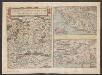
Carinthiae ducatus et Goritiae palatinatus, Enth. außerdem: Histriae tabula / à Petro Coppo descr., Zarae, Et Sebenici Descriptio
Kärnten, Grafschaft Görz Lazius, Wolfgang
Karte von Inner Oestreich oder den Herzogthümern Steyermark Kaernten und Krain der Grafschaft Görz und dem Triester Gouvernement
1 : 1300000 Gorizia (Itálie) Reilly, Franz Johann Josef von F.I.I. Reilly
Carintia
Mollova mapová sbírka Hoffmann, Johannes Hoffmann, Johann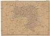
Charte vom Herzogthum Steyermark
1 : 870000 Štýrsko (Rakousko)
Charte vom Herzogthum Steyermark
1 : 870000 Štýrsko (Rakousko)
Karte von Herzogthum Steyermark
1 : 840000 Štýrsko (Rakousko) Tranquillo Mollo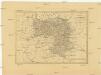
Charte von Herzogthum Steyermark
1 : 850000 Rakousko
Landschaften Innerösterreichs
Innerösterreich Historische Landeskunde
Karte von Herzogthum Steyermark
1 : 860000 Štýrsko (Rakousko) Florian Mollo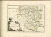


Reiseplan zu Würth's Spaziergang an das Mittelmeer
1 : 550000 Itálie severní Würth, Ludwig Riegel & Wiessner
Steyermark.
1 : 705000 Flemming, Carl
Charte von Innerösterreich oder den vereinigten Herzogthümern Steyermark und Kaernten
1 : 733000 Korutansko (Rakousko) in J. Riedl's Kunsthandlung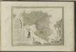

Vollstaendige Post-Karte des Herzogthums Steuermarks

Charte von Steyermark Kaernthen und Krain nebst der Grafschaft Görz
1 : 540000 Korutansko (Rakousko) Walch, Johann Joh. Walch
Vermehrte und Verbesserte Landkarten des Königreichs Ungarn :
1 : 500000 Mollova mapová sbírka Stier, Martin Böner, Johann-Alexander Endter, Martin
General-Karte von Steiermark
1 : 300000 Štýrsko (Rakousko) R. Lechner
Ducatus Stiriae et Carintiae Carniolae Cilleiae q; Comitatus, Nova Tabula que et Paris est Meridionalior Circuli Austriaci
1 : 910000 Mollova mapová sbírka Ottens, Reinier Ottens, Josua
Charte von Steyermark
Štýrsko (Rakousko) Kindermann, Joseph Karl Müller, Franz im Verlage des Kunst- und Industrie- Comptoirs
Charte von Steyermark
Štýrsko (Rakousko) Kindermann, Joseph Karl Müller, Franz im Verlage des Kunst- und Industrie-Comptoirs
Charte von Steyermark
Štýrsko (Rakousko) Kindermann, Joseph Karl Müller, Franz im Verlage des Kunst- und Industrie- Comptoirs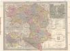
General Post und Strassen Karte des Herzogthums Steiermark
1 : 400000 Mariazell (Rakousko) Schulz, R. A. Peucker, Karl Artaria
Saltzburg archiepiscopatus cum ducatu Carinthiae [Karte], in: Gerardi Mercatoris Atlas, sive, Cosmographicae meditationes de fabrica mundi et fabricati figura, S. 406.
1 Karte aus Atlas Mercator, Gerhard Montanus, Petrus
[Štýrsko]
1 : 600000 Štýrsko (Rakousko) Anker
General-Karte von Steiermark
Lechner, R.
![Carinthiae Ducatus, Et Goritiae Palatinatus [Karte] , in: Theatrum orbis terrarum, S. 261.](https://images-2.georeferencer.com/images/iiif/378531473668/full/,300/0/native.jpg)

