Maps of Kärnten

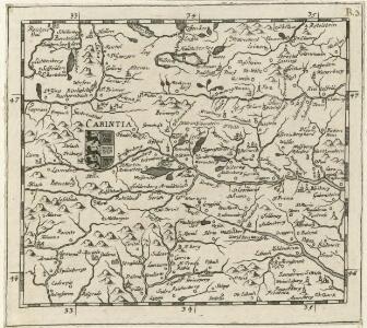
Carintia
Mollova mapová sbírka Hoffmann, Johannes Hoffmann, Johann
Carinthiae Ducatus, Et Goritiae Palatinatus [Karte] , in: Theatrum orbis terrarum, S. 261.
1 Karte aus Atlas Ortelius, Abraham
Carinthiae ducatus et Goritiae palatinatus, Enth. außerdem: Histriae tabula / à Petro Coppo descr., Zarae, Et Sebenici Descriptio
Kärnten, Grafschaft Görz Lazius, Wolfgang
Carinthiae Ducatus, Et Goritiae Palatinatus [Karte] , in: Theatrum orbis terrarum, S. 356.
1 Karte aus Atlas Ortelius, Abraham Vrients, Jan Baptista
Karte von Inner Oestreich oder den Herzogthümern Steyermark Kaernten und Krain der Grafschaft Görz und dem Triester Gouvernement
1 : 1300000 Gorizia (Itálie) Reilly, Franz Johann Josef von F.I.I. Reilly
Ducatus Stiriae et Carintiae Carniolae Cilleiae q; Comitatus, Nova Tabula que et Paris est Meridionalior Circuli Austriaci
1 : 910000 Mollova mapová sbírka Ottens, Reinier Ottens, Josua
Tyrolis Pars Meredeonales Episcopatvm Tridentinvm
1 : 118000 Mollova mapová sbírka Spergs, Joseph von Weinkopf, Anton Weinkopf, Antonius
Tyrolis Pars Meredeonales Episcopatvm Tridentinvm
1 : 118000 Mollova mapová sbírka Spergs, Joseph von Weinkopf, Anton Weinkopf, Antonius


Ducatus Carintiae et Carnioliae Cilleiaeque Comitatus
1 : 600000 Mollova mapová sbírka Wit, Frederik de Mortier, Pierre
Nova et accurata Carinthiae Ducatus Tabula geographica
1 : 355000 Mollova mapová sbírka Homann, Johann Baptist
Ducatus Carithiae
1 : 645000 Mollova mapová sbírka Weigel, Christoph Weigel, Christoph
Charte von Innerösterreich oder den vereinigten Herzogthümern Steyermark und Kaernten
1 : 733000 Korutansko (Rakousko) in J. Riedl's Kunsthandlung
Vollstaendige Post-Karte des Herzogthums Steuermarks

General-Karte von Steiermark
1 : 300000 Štýrsko (Rakousko) R. Lechner

Charte von Steyermark
Štýrsko (Rakousko) Kindermann, Joseph Karl Müller, Franz im Verlage des Kunst- und Industrie- Comptoirs
Charte von Steyermark
Štýrsko (Rakousko) Kindermann, Joseph Karl Müller, Franz im Verlage des Kunst- und Industrie-Comptoirs
Charte von Steyermark
Štýrsko (Rakousko) Kindermann, Joseph Karl Müller, Franz im Verlage des Kunst- und Industrie- Comptoirs
Vermehrte und Verbesserte Landkarten des Königreichs Ungarn :
1 : 500000 Mollova mapová sbírka Stier, Martin Böner, Johann-Alexander Endter, Martin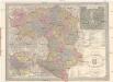
General Post und Strassen Karte des Herzogthums Steiermark
1 : 400000 Mariazell (Rakousko) Schulz, R. A. Peucker, Karl Artaria
Karte von Steiermark und Krain

Ducatus Styriae tabula
1 : 925000 Štýrsko (Rakousko) Granelli, Carlo Engelbrecht, Christian Engelbrecht et Pfeffel
Laibach, Villach, Kufstein, Belluno
1 : 750000 Belluno (Itálie : provincie) K.u.k. militär-geografisches Institut
Kronland Steyermark
1 : 600000 Štýrsko (Rakousko) C. Flemming
General-Karte von Steiermark
Lechner, R.
General-Karte des Herzogthums Steyermark
1 : 288000 Slovinsko