Maps of Δήμος Ικαρίας
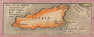
Insular. Aliquot Aegaei Maris Antiqua Descrip.[:] [Icaria.] [Karte], in: Theatrum orbis terrarum, S. 419.
1 Karte aus Atlas Ortelius, Abraham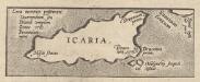
Insular. Aliquot Aegaei Maris Antiqua Descrip.[:] [Icaria.] [Karte], in: Theatrum orbis terrarum, S. 517.
1 Karte aus Atlas Ortelius, Abraham Vrients, Jan Baptista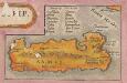
Insular. Aliquot Aegaei Maris Antiqua Descrip.[:] [Samus., Ionica.] [Karte], in: Theatrum orbis terrarum, S. 419.
1 Karte aus Atlas Ortelius, Abraham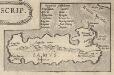
Insular. Aliquot Aegaei Maris Antiqua Descrip.[:] [Samus., Ionica.] [Karte], in: Theatrum orbis terrarum, S. 517.
1 Karte aus Atlas Ortelius, Abraham Vrients, Jan Baptista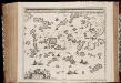
Archipelagi meridionalis, seu Cycladum insularum accurata delineatio / auctore I. Laurenbergio
1 : 650000 Annotatie: Kaart uitgegeven in de periode 1650-1662; Origineel is Blad 171 in atlas factice; Annotatie geografische gegevens: 4 schaalstokken: 8 Mill. Germ., en: 10 Mill. Gall., en: 30 Mill. Ital., en: 300 Stadia [S.l.] : [s.n.]
CYCLADES | INSVLÆ | IN MARE ÆGÆO, | hodie | ARCHIPELAGO
Auctore | I. LAVRENBERGIO Amsterdami, J. Blaeu excudit
Archipelagi Meridionalis seu Cycladum Insularum accurata Delineatio. [Karte], in: Novus atlas absolutissimus, Bd. 10, S. 234.
1 Karte aus Atlas Janssonius Offizin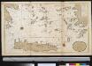
Het zuijderdeel van de Archipel Lagusche Eijlanden int groodt
Greece Gerard van Keulen
90. Anatolia occidentale, Isole Egee.
1 : 1500000 Touring club italiano
Neueste Karte von Griechenland
Grosser Hand-Atlas über alle Theile der Erde in 170 Karten Meyer, J. Verlag des Bibliographischen Instituts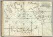
Carte De La Mer Mediterranee. XI.
Roux, Joseph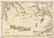
Mittelmeer
1 : 600000 Egejské moře Reichs-Marine-Amt
Turkey
1 : 6170000 Kréta (Řecko) Walker, C. Baldwin & Cradock
Iles de L'archipel; Dschezaïr
Nouvel atlas physique politique et historique de l'Empire ottoman et des états limitrophes en Europe, en Asie et en Afrique, en quarante feuilles Hellert, J.J. Bellizard, Dufour et Cie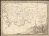
Parte dell'Asia Minore per servire di VI foglio della carta generale dell'Ungheria e della Turchia Europea
1 : 1
Carte réduite de la partie Méridionale de l’Archipel
Carte réduite de la partie Méridionale de l'Archipel, rédigée d'après les travaux exécutées dans les années 1818 & 1819 par M. Gauttier. [Paris] : Dépôt Général de la Marine

Griechenland und die Jonischen Inseln
Schul-Atlas in 36 Karten Völter, Daniel Verlag der J.M. Dannheimer'schen Buchhandlung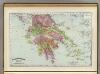
Greece.
1 : 1470000 Rand McNally and Company
[Die Balkan-Halbinsel, Blatt 4]
Adolf Stieler's Handatlas über alle Theile der Erde und über das Weltgebäude Stieler, Adolf Justus Perthes
Griechenland
1 : 2300000 Řecko F. A. Brouckaus' Geogr.-artist. Anstalt
GRAECIAE ANTIQUAE DESIGNATIO NOVA
Řecko Lotter, Tobias Conrad impensis T. Conr. Lotteri
Graeciae antiquae designatio nova
Řecko Lotter, Tobias Conrad impensis T. Conr. Lotteri
Greece.
1 : 1470000 Mitchell, Samuel Augustus
Greece.
1 : 1470000 Mitchell, Samuel Augustus
L'Archipel.
1 : 1070000 Garnier, F. A., 1803-1863
Ancient Greece.
1 : 2500000 Mitchell, Samuel Augustus
Das Ägäische Meer mit Kreta
1 : 1750000 Egejské moře (oblast) Carl Flemming
Grecian archipelago
1 : 1840000 Egejské ostrovy (Řecko a Turecko) Smith, William Walker, C. Society for the diffusion of useful knowledge
![Insular. Aliquot Aegaei Maris Antiqua Descrip.[:] [Icaria.] [Karte], in: Theatrum orbis terrarum, S. 419.](https://images-2.georeferencer.com/images/iiif/431593703682/full/,300/0/native.jpg)

