Maps of Δήμος Νάξου και Μικρών Κυκλάδων

Archipelagi Insularum Aliquot Descrip., [Nicsia] [Karte], in: Theatrum orbis terrarum, S. 246.
1 Karte aus Atlas Ortelius, Abraham
Archipelagi Insularum Aliquot Descrip., [Nicsia] [Karte], in: Theatrum orbis terrarum, S. 341.
1 Karte aus Atlas Ortelius, Abraham Vrients, Jan Baptista
Candia cum Insulis aliquot circa Graeciam[:] [Nicsia] [Karte], in: Gerardi Mercatoris Atlas, sive, Cosmographicae meditationes de fabrica mundi et fabricati figura, S. 493.
1 Karte aus Atlas Mercator, Gerhard Montanus, Petrus
Candia cum Insulis aliquot circa Graeciam[:] [Nicsia] [Karte], in: Gerardi Mercatoris et I. Hondii Newer Atlas, oder, Grosses Weltbuch, Bd. 2, S. 336.
1 Karte aus Atlas Mercator, Gerhard und Hondius, Jodocus Jansson, Jan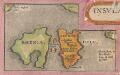
Insular. Aliquot Aegaei Maris Antiqua Descrip.[:] [Rhenia. und Tremon.] [Karte], in: Theatrum orbis terrarum, S. 419.
1 Karte aus Atlas Ortelius, Abraham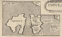
Insular. Aliquot Aegaei Maris Antiqua Descrip.[:] [Rhenia.] [Karte], in: Theatrum orbis terrarum, S. 517.
1 Karte aus Atlas Ortelius, Abraham Vrients, Jan Baptista
Die Cycladischen Inseln
1 : 1160000 Kyklady (Řecko) Anville, Jean-Baptiste Bourguinon d'
[INSULA CRETA hodie CANDIA]
1 : 925000 Egejské moře-oblast Homann, Johann Baptist Ioh. Bapt. Homannus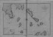
Begulia, Melada Island, Dalmatia
Port Beguglia ... Levé en 1819 par le Capit. W. H. Smyth. [Paris],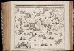
Archipelagi meridionalis, seu Cycladum insularum accurata delineatio / auctore I. Laurenbergio
1 : 650000 Annotatie: Kaart uitgegeven in de periode 1650-1662; Origineel is Blad 171 in atlas factice; Annotatie geografische gegevens: 4 schaalstokken: 8 Mill. Germ., en: 10 Mill. Gall., en: 30 Mill. Ital., en: 300 Stadia [S.l.] : [s.n.]
Insula Creta hodie Candia
1 : 900000 Kréta (Řecko) Homann, Johann Baptist Joh. Bapt. Homannus
CYCLADES | INSVLÆ | IN MARE ÆGÆO, | hodie | ARCHIPELAGO
Auctore | I. LAVRENBERGIO Amsterdami, J. Blaeu excudit
Archipelagi Meridionalis seu Cycladum Insularum accurata Delineatio. [Karte], in: Novus atlas absolutissimus, Bd. 10, S. 234.
1 Karte aus Atlas Janssonius Offizin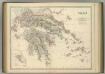
Greece.
1 : 917000 Johnston, Alexander Keith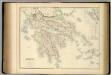
Greece.
1 : 950000 Fullarton, A. & Co.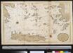
Het zuijderdeel van de Archipel Lagusche Eijlanden int groodt
Greece Gerard van Keulen
Greece.
1 : 1470000 Tanner, Henry S.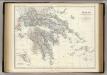
Greece.
1 : 917000 Johnston, Alexander Keith, 1804-1871
Greece.
1 : 1500000 Tanner, Henry S.
Greece.
1 : 1500000 Tanner, Henry S.
Griechenland.
1 : 1600000 Meyer, Joseph, 1796-1856
Ancient Greece : southern part
1 : 1500000 published under the superintendence of the Society for the Diffusion of Useful Knowledge engraved by J. & C. Walker London : Baldwin and Cradock
Turkey III : containing the southern part of Greece and Candia
published under the superintendence of the Society for the Diffusion of Useful Knowledge engraved by J. & C. Walker London : Baldwin and Cradock
Greece. (with) inset maps of Corfu and Stampalia.
1 : 1647360 Tallis, J. & F.
Das Königreich Hellas oder Griechenland und die Republik der Seiben Ionischen Inseln (Ephtánisos)
Řecko Kiepert, Heinrich Herzberg, H. Verlag des Geographischen Instituts
Greece.
1 : 1480000 Mitchell, Samuel Augustus
Griechenland und die Jonischen Inseln mit Beachtung der Klassischen Zeit
Hand-Atlas über alle Theile der Erde nach dem neuesten Zustande und über das Weltgebäude Stieler, Adolf bei Justus Perthes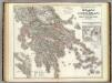
Hellas, Ionischen Inseln.
1 : 800000 Kiepert, Heinrich, 1818-1899
Neueste Karte von Griechenland
Grosser Hand-Atlas über alle Theile der Erde in 170 Karten Meyer, J. Verlag des Bibliographischen Instituts
![Archipelagi Insularum Aliquot Descrip., [Nicsia] [Karte], in: Theatrum orbis terrarum, S. 246.](https://images-2.georeferencer.com/images/iiif/149283850947/full/,300/0/native.jpg)

