Maps of Cyclades
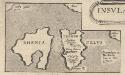
Insular. Aliquot Aegaei Maris Antiqua Descrip.[:] [Rhenia.] [Karte], in: Theatrum orbis terrarum, S. 517.
1 Karte aus Atlas Ortelius, Abraham Vrients, Jan Baptista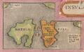
Insular. Aliquot Aegaei Maris Antiqua Descrip.[:] [Rhenia. und Tremon.] [Karte], in: Theatrum orbis terrarum, S. 419.
1 Karte aus Atlas Ortelius, Abraham
Archipelagi Insularum Aliquot Descrip., [Nicsia] [Karte], in: Theatrum orbis terrarum, S. 341.
1 Karte aus Atlas Ortelius, Abraham Vrients, Jan Baptista
Archipelagi Insularum Aliquot Descrip., [Nicsia] [Karte], in: Theatrum orbis terrarum, S. 246.
1 Karte aus Atlas Ortelius, Abraham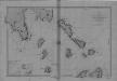
Begulia, Melada Island, Dalmatia
Port Beguglia ... Levé en 1819 par le Capit. W. H. Smyth. [Paris],
Die Cycladischen Inseln
1 : 1160000 Kyklady (Řecko) Anville, Jean-Baptiste Bourguinon d'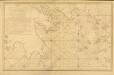
Carte des Côtes de la Grèce depuis Navarin en Morée
Carte des Côtes de la Grèce depuis Navarin en Morée, jusqu'au Cap Doro ... avec la partie de l'Archipel qu comprend les Îles Cyclades, dressée d'après les observations astronomiques et nautiques de M. de Chabert. [Paris] : Dépôt Général ... de la Marine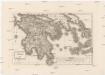
Peloponesus et Cyclades
1 : 710000 Kyklady (Řecko) Reichard, Christian Gottlieb Campius, D. a D. Campio
Archipelagi Insularum Aliquot Descrip., [Negroponte] [Karte], in: Theatrum orbis terrarum, S. 341.
1 Karte aus Atlas Ortelius, Abraham Vrients, Jan Baptista
Negroponte In. [Karte], in: Gerardi Mercatoris Atlas, sive, Cosmographicae meditationes de fabrica mundi et fabricati figura, S. 523.
1 Karte aus Atlas Mercator, Gerhard Montanus, Petrus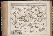
Archipelagi meridionalis, seu Cycladum insularum accurata delineatio / auctore I. Laurenbergio
1 : 650000 Annotatie: Kaart uitgegeven in de periode 1650-1662; Origineel is Blad 171 in atlas factice; Annotatie geografische gegevens: 4 schaalstokken: 8 Mill. Germ., en: 10 Mill. Gall., en: 30 Mill. Ital., en: 300 Stadia [S.l.] : [s.n.]
Insula Creta hodie Candia
1 : 900000 Kréta (Řecko) Homann, Johann Baptist Joh. Bapt. Homannus
CYCLADES | INSVLÆ | IN MARE ÆGÆO, | hodie | ARCHIPELAGO
Auctore | I. LAVRENBERGIO Amsterdami, J. Blaeu excudit
Alt Griechenland
Athény-oblast (Řecko) Loewenberg, Julius Kt., I. V.
Archipelagi Meridionalis seu Cycladum Insularum accurata Delineatio. [Karte], in: Novus atlas absolutissimus, Bd. 10, S. 234.
1 Karte aus Atlas Janssonius Offizin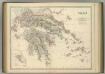
Greece.
1 : 917000 Johnston, Alexander Keith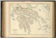
Greece.
1 : 950000 Fullarton, A. & Co.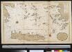
Het zuijderdeel van de Archipel Lagusche Eijlanden int groodt
Greece Gerard van Keulen
Morea
Řecko Müller, Jos. D. Šafařík, Pavel Josef
Greece.
1 : 1470000 Tanner, Henry S.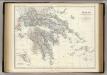
Greece.
1 : 917000 Johnston, Alexander Keith, 1804-1871
Greece.
1 : 1500000 Tanner, Henry S.
Greece.
1 : 1500000 Tanner, Henry S.
Griechenland.
1 : 1600000 Meyer, Joseph, 1796-1856
Ancient Greece : southern part
1 : 1500000 published under the superintendence of the Society for the Diffusion of Useful Knowledge engraved by J. & C. Walker London : Baldwin and Cradock
Turkey III : containing the southern part of Greece and Candia
published under the superintendence of the Society for the Diffusion of Useful Knowledge engraved by J. & C. Walker London : Baldwin and Cradock
Greece. (with) inset maps of Corfu and Stampalia.
1 : 1647360 Tallis, J. & F.

Das Königreich Hellas oder Griechenland und die Republik der Seiben Ionischen Inseln (Ephtánisos)
Řecko Kiepert, Heinrich Herzberg, H. Verlag des Geographischen Instituts
![Insular. Aliquot Aegaei Maris Antiqua Descrip.[:] [Rhenia.] [Karte], in: Theatrum orbis terrarum, S. 517.](https://images-2.georeferencer.com/images/iiif/562899236641/full/,300/0/native.jpg)

