Maps of Ticino
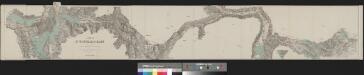
Karte der St. Gotthard-Bahn in drei Blättern
1 : 100000 1 Karte auf 3 Bl. gestochen im Topographischen Institut von Wurster Randegger & Co. in Winterthur 1880 Orell Füssli, Zürich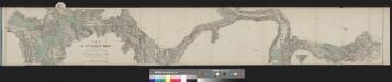
Karte der St. Gotthard-Bahn in drei Blättern
1 : 100000 1 Karte auf 3 Bl. gestochen im Topographischen Institut von Wurster Randegger & Co. in Winterthur 1880 C.F. Prell, Luzern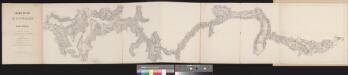
Chemin de fer par le St. Gotthard
1 : 100000 1 Karte dressé par A. Beckh et R. Gerwig Wurster, Winterthur
Landtaflen
1 Atlas [von Johannes Stumpf] Christoffel Froschower, Zürych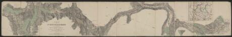
Karte der St. Gotthard-Bahn in drei Blättern
1 : 100000 Topographische Anstalt von Wurster, Randegger & Cie. (Winterthur) C.F. Prell
Passage des alpes
1 : 100000 1 Karte dressé d'après les instructions de J. Michel par L. Pestalozzi : plan général Wurster, Winterthur
Le Theatre de Bellone :
Mollova mapová sbírka Schenk, Pieter Braakman, Adriaan
Atlas der Schweiz
1 : 450000 1 Atlas (18 Bl.) gez. u. gest. v. J. Scheurmann Orell Fussli, Zurich
Distanzenkarte von der Schweiz
1 : 200000 1 Karte in 8 Teilen nach den besten Hülfsquellen bearb. von R. Huber Wagner, Bern
<<Der>> Canton Ticino
1 : 350000 1 Karte gezeichnet v. H. Keller nach Paolo Ghiringelli ; gest. von J.J. Scheurmann [Orell Füssli & Comp.], [Zürich]
Atlas de la Suisse
1 : 450000 1 Atlas (19 Bl.) dessiné par MM. H. Keller, Scheurmann, Pfyffer d'Altishofen, Osterwald, etc. ; gravé par M. Scheurmann Orell Füssli & Co., Zürich
<<Der>> Canton Ticino
1 : 350000 1 Karte gezeichnet v. H. Keller nach Paolo Ghiringelli ; gest. von J.J. Scheurmann Orell, Füssli & Cp., Zürich
Carte de la Suisse avec les plans des cheflieux des 22 cantons
1 : 200000 1 Karte auf 8 Bl. dessinée et publié par Henri Keller ; Lithogr. von J. Schweizer = Charte der Schweiz mit den Grundrissen der Hauptorte der 22 Cantone Keller, Zürich
Ticino
1 : 1450000 [Stumme Kartenskizzen der ganzen Schweiz und der einzelnen Kantone zu Unterrichtszwecken] Schulbuchhandlung Antenen
<<Der>> Canton Ticino
1 : 350000 1 Karte gezeichnet v. H. Keller nach Paolo Ghiringelli ; gest. von J.J. Scheurmann Orell, Füssli & Cp., Zürich
Wandkarte der Schweiz
1 : 200000 1 Karte auf 8 Blättern J.M. Ziegler Wurster, Winterthur
[Exactissima Helvetiae, Rhaetiae, Valesiae ... tabula]
1 : 850000 9 Karten [Kopie von Adrian Braakman] [chez Pierre Schenk et Adrian Braakman], [Amsterdam]
Locarno
1 : 200000 1 Karte entworfen und bearbeitet von Woerl ; in Stein gestochen unter seiner Leitung 1835 ; Lithographie von B. Herder Herder, Freiburg im Breisgau
<<Der>> Canton Ticino
1 : 350000 1 Karte gezeichnet v. H. Keller nach Paolo Ghiringelli ; gest. von J.J. Scheurmann Orell Füssli & Cp., Zürich
Carta del Cantone di Ticino
1 : 250000 1 Karte disegto da E. Keller & C. Hardmeier, Lit. da Grimminger Huber & Co., S. Gallo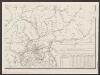
Postkarte der schweizerischen Eidgenossenschaft
1 : 300000 Südost-Blatt Dufour, Guillaume Henri ; Stengel, Johann Rudolf ; Mohr, Ernst Rudolf Wurster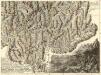
Nova Helvetiae Tabula Geographica
1 : 290000 Mollova mapová sbírka Scheuchzer, Johann Jakob Huber, Johann Heinrich Scheuchzer, Johann Jakob
Carta del cantone di Ticino
1 : 250000 1 Karte disegto da E. Keller & C. Hardmeier ; Lith. da Grimminger [Verlag nicht ermittelbar], [Erscheinungsort nicht ermittelbar]
Reliefkarte der Centralschweiz
1 Vogelschaukarte construirt und gezeichnet von X. Imfeld ; hrsg. vom Verein zur Förderung des Fremdenverkehrs am Vierwaldstättersee und Umgebung Wurster, Zürich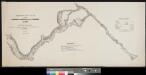
Uebersichtsplan einer Eisenbahn vom Langensee über den Lucmanier nach Chur
1 : 100000 1 Karte [J.] Michel ; L. Pestalozzi [Verlag nicht ermittelbar], [Erscheinungsort nicht ermittelbar]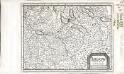
Argow
1 Karte : Kupferdruck ; 14 x 18 cm s.n.
Argow
1 : 243000 Aargau (Švýcarsko : kanton) Mercator, Gerhard G. Mercator
Rete trigonometrical del Cantone Ticino
1 : 250000 Ufficio topografico federale
Canton Ticino
1 : 350000 Keller, Heinrich ; Scheuermann, Johann Jakob Orell, Füssli & Cp.


