Maps of Ticino

Distanzenkarte von der Schweiz
1 : 200000 1 Karte in 8 Teilen nach den besten Hülfsquellen bearb. von R. Huber Wagner, Bern
Ticino
1 : 1450000 [Stumme Kartenskizzen der ganzen Schweiz und der einzelnen Kantone zu Unterrichtszwecken] Schulbuchhandlung Antenen
<<Der>> Canton Ticino
1 : 350000 1 Karte gezeichnet v. H. Keller nach Paolo Ghiringelli ; gest. von J.J. Scheurmann Orell, Füssli & Cp., Zürich
<<Der>> Canton Ticino
1 : 350000 1 Karte gezeichnet v. H. Keller nach Paolo Ghiringelli ; gest. von J.J. Scheurmann Orell, Füssli & Cp., Zürich
Carte de la Suisse avec les plans des cheflieux des 22 cantons
1 : 200000 1 Karte auf 8 Bl. dessinée et publié par Henri Keller ; Lithogr. von J. Schweizer = Charte der Schweiz mit den Grundrissen der Hauptorte der 22 Cantone Keller, Zürich
Atlas de la Suisse
1 : 450000 1 Atlas (19 Bl.) dessiné par MM. H. Keller, Scheurmann, Pfyffer d'Altishofen, Osterwald, etc. ; gravé par M. Scheurmann Orell Füssli & Co., Zürich
Wandkarte der Schweiz
1 : 200000 1 Karte auf 8 Blättern J.M. Ziegler Wurster, Winterthur
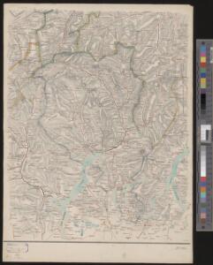
Carta del Cantone di Ticino
1 : 250000 1 Karte disegto da E. Keller & C. Hardmeier, Lit. da Grimminger Huber & Co., S. Gallo
Atlas der Schweiz
1 : 450000 1 Atlas (18 Bl.) gez. u. gest. v. J. Scheurmann Orell Fussli, Zurich
<<Der>> Canton Ticino
1 : 350000 1 Karte gezeichnet v. H. Keller nach Paolo Ghiringelli ; gest. von J.J. Scheurmann Orell Füssli & Cp., Zürich
Carta del cantone di Ticino
1 : 250000 1 Karte disegto da E. Keller & C. Hardmeier ; Lith. da Grimminger [Verlag nicht ermittelbar], [Erscheinungsort nicht ermittelbar]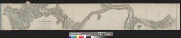
Karte der St. Gotthard-Bahn in drei Blättern
1 : 100000 1 Karte auf 3 Bl. gestochen im Topographischen Institut von Wurster Randegger & Co. in Winterthur 1880 C.F. Prell, Luzern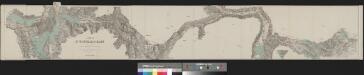
Karte der St. Gotthard-Bahn in drei Blättern
1 : 100000 1 Karte auf 3 Bl. gestochen im Topographischen Institut von Wurster Randegger & Co. in Winterthur 1880 Orell Füssli, Zürich
Rete trigonometrical del Cantone Ticino
1 : 250000 Ufficio topografico federale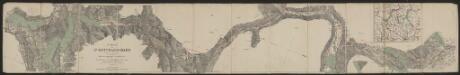
Karte der St. Gotthard-Bahn in drei Blättern
1 : 100000 Topographische Anstalt von Wurster, Randegger & Cie. (Winterthur) C.F. Prell
Nova Helvetiae Tabula Geographica
1 : 290000 Mollova mapová sbírka Scheuchzer, Johann Jakob Huber, Johann Heinrich Scheuchzer, Johann Jakob
Canton Ticino
1 : 350000 Keller, Heinrich ; Scheuermann, Johann Jakob Orell, Füssli & Cp.
Carta del cantone di Ticino
1 : 150000 1 Karte J.M. Ziegler ; Gebirgsstich v. R. Leuzinger ; Schrift von P. Steiner Stich, Druck u. Verlag v. J. Wurster u. Comp., Winterthur
Carta del cantone di Ticino
1 : 150000 Ziegler, Jakob Melchior Stich, Druck u. Verlag v. J. Wurster u. Comp.
Carta del Cantone di Ticino
1 : 250000 Keller, Heinrich ; Hardmeier, C. ; Grimminger, Adolf Enrico Füssli & Co.

<<Der>> Canton Ticino
1 : 350000 1 Karte gezeichnet v. H. Keller nach Paolo Ghiringelli ; gest. von J.J. Scheurmann [Orell Füssli & Comp.], [Zürich]
Atlas Suisse
1 : 120000 16 Karten levé et dessiné par J.H. Weiss [et Joachim Eugen Müller] aux frais de J.R. Meyer à Aarau dans les années 1786 à 1802 ; gravée [sic] par [Christophe] Guérin, [Matthias Gottfried] Eichler et [Johann Jakob] Scheurmann [Johann Rudolf Meyer], Aarau
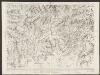
Majeure partie des Cantons de Bellinzona et de Lugano et les frontieres de la Republique Italienne.
From Atlas Suisse. Levé et dessiné par J. H. Weiss aux fraix de J. R. Meyer á Aarau dans les années 1786 á 1802. Gravée par Guerin, Eichler, et Scheurmann.
Atlas Suisse
1 : 120000 16 Karten levé et dessiné par J.H. Weiss [et Joachim Eugen Müller] aux frais de J.R. Meyer à Aarau dans les années 1786 à 1802 ; gravée [sic] par [Christophe] Guérin, [Matthias Gottfried] Eichler et [Johann Jakob] Scheurmann [Johann Rudolf Meyer], Aarau
Der Canton Ticino
1 : 22200 Ticino (Švýcarsko) Keller, H. Ghiringelli, Paolo
Taschen-Atlas der Schweiz
1 Atlas (25 S., 20 Taf.) gezeichnet und gestochen von Emil Wagner = Atlas de poche de la Suisse : 26 cartes en couleurs / dessinées et gravées par Émile Wagner Eggimann, Genf
Le Mont Gotthard et partie des Grisons
1 : 108000 Weiss, Johann Heinrich ; Meyer, Johann Rudolf J. R. Meyer
Stehende Gewässer
Atlas der Hydrographie Berghaus, Hermann Justus Perthes