Maps of Ticino

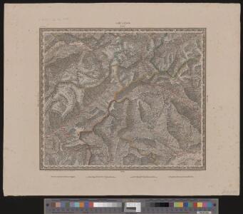
Locarno
1 : 200000 1 Karte entworfen und bearbeitet von Woerl ; in Stein gestochen unter seiner Leitung 1835 ; Lithographie von B. Herder Herder, Freiburg im Breisgau
Reisekarte der Schweiz
1 : 500000 1 Atlas (1, 6 Bl.) gezeichnet von H. Keller und gestochen von J. Scheurmann = Carte routière de la Suisse / dessinée par H. Keller et gravée par J. Scheurmann bey Fuessli und Comp., Zürich
[Keller's Reisekarte der Schweiz]
1 : 500000 1 Karte auf 6 Bl. gezeichnet v. H. Keller ; gest. v. J.J. Scheurmann [Keller], Zürich
Schulwandkarte zur Geschichte der Schweiz
1 : 180000 1 Karte auf 6 Bl. bearbeitet v. W. Oechsli u. A. Baldamus ; gezeichnet von Ed. Gaebler Kartograph. Verlagsanstalt von Georg Lang, Leipzig
Atlas de la Suisse
1 : 450000 1 Atlas (19 Bl.) dessiné par MM. H. Keller, Scheurmann, Pfyffer d'Altishofen, Osterwald, etc. ; gravé par M. Scheurmann Orell Füssli & Co., Zürich
Atlas der Schweiz
1 : 450000 1 Atlas (18 Bl.) gez. u. gest. v. J. Scheurmann Orell Fussli, Zurich
Valesiae Prior Et VI. Nova Tabula. [Karte], in: Claud. Ptolemaeus. Geographia lat. cum mappis [...], S. 353.
1 Karte aus Atlas Münster, Sebastian [und Ptolemaeus, Claudius]
Schulwandkarte zur Geschichte der Schweiz
1 : 180000 Südblatt Oechsli, Wilhelm ; Baldamus, Alfred Kartograph. Verlagsanstalt von Georg Lang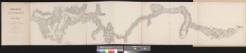
Chemin de fer par le St. Gotthard
1 : 100000 1 Karte dressé par A. Beckh et R. Gerwig Wurster, Winterthur
Landtaflen
1 Atlas [von Johannes Stumpf] Christoffel Froschower, Zürych
Argow cum parte merid. Zurichgow [Karte], in: Theatrum orbis terrarum, sive, Atlas novus, Bd. 1, S. 297.
1 Karte aus Atlas Blaeu, Joan Blaeu, Willem Janszoon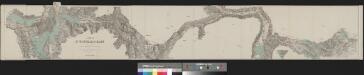
Karte der St. Gotthard-Bahn in drei Blättern
1 : 100000 1 Karte auf 3 Bl. gestochen im Topographischen Institut von Wurster Randegger & Co. in Winterthur 1880 Orell Füssli, Zürich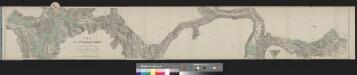
Karte der St. Gotthard-Bahn in drei Blättern
1 : 100000 1 Karte auf 3 Bl. gestochen im Topographischen Institut von Wurster Randegger & Co. in Winterthur 1880 C.F. Prell, Luzern
ARGOW | cum parte merid. | ZVRICHGOW
Auctore Ger. Mercatore. [Amsterdam : Joan Blaeu]
Le Theatre de Bellone :
Mollova mapová sbírka Schenk, Pieter Braakman, Adriaan
[Exactissima Helvetiae, Rhaetiae, Valesiae ... tabula]
1 : 850000 9 Karten [Kopie von Adrian Braakman] [chez Pierre Schenk et Adrian Braakman], [Amsterdam]
Argow cum parte merid. Zurichgow [Karte], in: Novus Atlas, das ist, Weltbeschreibung, Bd. 1, S. 254.
1 Karte aus Atlas Blaeu, Joan Blaeu, Willem Janszoon
Argow cum parte merid. Zurichgow [Karte], in: Novus atlas absolutissimus, Bd. 4, S. 245.
1 Karte aus Atlas Janssonius Offizin
Argow
1 : 243000 Aargau (Švýcarsko : kanton) Mercator, Gerhard G. Mercator
[Argow] [Karte], in: Gerardi Mercatoris et I. Hondii Newer Atlas, oder, Grosses Weltbuch, Bd. 1, S. 265.
1 Karte aus Atlas Mercator, Gerhard und Hondius, Jodocus Jansson, Jan

Carte de la Suisse avec les plans des cheflieux des 22 cantons
1 : 200000 1 Karte auf 8 Bl. dessinée et publié par Henri Keller ; Lithogr. von J. Schweizer = Charte der Schweiz mit den Grundrissen der Hauptorte der 22 Cantone Keller, Zürich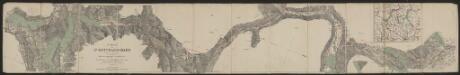
Karte der St. Gotthard-Bahn in drei Blättern
1 : 100000 Topographische Anstalt von Wurster, Randegger & Cie. (Winterthur) C.F. Prell
Atlas der Schweiz
1 : 450000 1 Atlas (18 Bl.) gez. u. gest. v. J. Scheurmann Orell Fussli, Zurich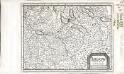
Argow
1 Karte : Kupferdruck ; 14 x 18 cm s.n.
Argow cum parte merid. Zvrichgow
1 Karte : Kupferdruck ; 37 x 48 cm Mercator; Janssonius Joannes Janssonius
Argow cum parte merid. Zvrichgow
1 Karte : Kupferdruck ; 37 x 48 cm Mercator; Schenk; Valck apud G. Valk et P. Schenk
Argow cum parte merid. Zvrichgow
1 Karte : Kupferdruck ; 37 x 49 cm Blaeu; Mercator Willem Janszoon Blaeu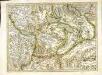
[Argow]
1 Karte : Kupferdruck ; 34 x 45 cm Mercator; Hondius Henricus Hondius